Observation: Mineral Fork

Observation Date
12/15/2019
Observer Name
Champion/Gagne/Meisenheimer/Staples
Region
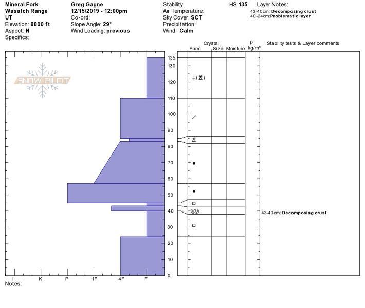
Salt Lake » Big Cottonwood Canyon » Mineral Fork
Location Name or Route
Mineral Fork
Weather
Sky
Scattered
Precipitation
Light Snowfall
Wind Speed
Calm
Weather Comments
Light S-1 snowfall late afternoon. Windless.
Snow Characteristics
New Snow Depth
4"
New Snow Density
Low
Snow Surface Conditions
Powder
Snow Characteristics Comments
Snow surface was very low-density with denser storm snow underneath. HS above 8500' was ~1.2 meters (4') Some wind-affect noted up high along the ridges, with cornices along east-facing ridgelines.
Red Flags
Red Flags
Recent Avalanches
Poor Snowpack Structure
Red Flags Comments
We were finding evidence of poor snowpack structure on northerly aspects above ~8500. Below that there was little evidence of persistent weak layer (faceted snow) down near the ground. Where we were finding it below 8500' it was shallow ~5 cms and damp grains. Above 8500' different story with 25-40 cms of very weak faceted snow near the ground.
Avalanche Problem #1
Problem
Persistent Weak Layer
Trend
Same
Problem #1 Comments
Poor snowpack structure remains a lingering concern. Some pits were ECTN/ECTX, but we also got full propagation on one pit ECTP28 failing down 90 cms on a layer of faceted snow underneath a decomposing crust. (Photo/profile below.) No collapsing or other signs of instability - just a 4 or 5 lemon snowpack structure. Team of four UAC forecasters in agreement the recent load of snow/wind/water was too much of a stress on this persistent weak layer and we were all avoiding being on or below anything steeper than 30 degrees on a northwest through east aspect at the mid and upper elevations.
Comments
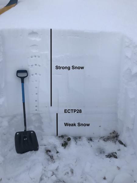
Photos of pit and pit profile showing poor structure of strong snow over weak snow. This was on a north aspect at 8900'
Today's Observed Danger Rating
Considerable
Tomorrows Estimated Danger Rating
Considerable