Sign Up for the Utah Snow and Avalanche Workshop (USAW) on December 7th!

Forecast for the Ogden Area Mountains

Drew Hardesty
Issued by Drew Hardesty on
Tuesday morning, November 26, 2019
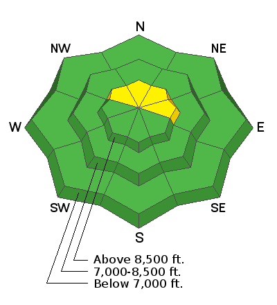
A MODERATE danger exists in upper elevation wind drifted slopes. Human triggered avalanches are possible but generally relegated to steep northerly to easterly facing slopes. Sluffing in the new snow is likely.
Outlook: the outlook is not good for the rest of the week as the danger may reach CONSIDERABLE to HIGH in the coming days. This includes sidecountry terrain. Please spread the word to friends and neighbors who may be unaware.
Low
Moderate
Considerable
High
Extreme
Learn how to read the forecast here
Special Announcements
Terrain in unopened resorts must be treated as backcountry.
The First Annual Statewide Avalanche Awareness Week is December 2-7. We have a week full of fun and educational events planned. Check out the schedule here.
Click on the Education menu on our webpage for a full list of classes from the UAC and other providers. Check out the Know Before You Go eLearning program for free, online, avalanche classes.
Weather and Snow
Skies are partly cloudy with mountain temperatures in the single digits and low teens. Yesterday's cold front ushered in 4-8" of new snow with densities of 6-8% density snow (Snow water equivalents of 0.21-0.7") favoring the Ben Lomond and Monte Cristo terrain. Winds are northerly, blowing 10-15mph. Mt Ogden has hourly speeds of 15-20mph with gusts to 35. Snow depths are roughly 10-20".
We'll see a bit of a break today with partly-becoming-mostly cloudy skies, light southwest winds, and temps in the teens. Enjoy the breather while you can. A storm spinning off the Oregon coast will be the main event over the next several days, ushering in heavy and heavier snowfall, strong southerly winds, and dangerous avalanche conditions. Up to and over two feet of snow can't be ruled out by early weekend. (Plus there are hints of another system for early next week.) Buckle up.
Recent Avalanches
None reported.
Ad
Avalanche Problem #1
Persistent Weak Layer
Type
Location
Likelihood
Size
Description
On upper elevation shady slopes, the new snow fell and was drifted on patches of sugary weak faceted snow that may be unstable in localized terrain. It is limited in extent, but this terrain should be approached with caution as human triggered avalanches may be possible and potentially triggered at a distance. Take great heed if experiencing audible collapsing or shooting cracks. Low angle terrain is recommended.
Avalanche Problem #2
New Snow
Type
Location
Likelihood
Size
Description
Sluffing is likely on the steepest slopes of the mid and upper elevations in areas that had pre-existing snow. These are the northwest to north to east facing slopes. The surface snow is so weak that the new snow will bond poorly and scrape down to the underlying crusts. These point-release avalanches will run naturally and with human provocation and may leave decent debris piles.