Forecast for the Ogden Area Mountains

Drew Hardesty
Issued by Drew Hardesty on
Monday morning, November 25, 2019
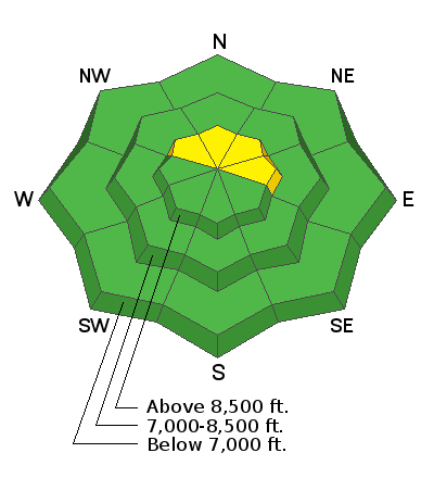
The avalanche danger will be on the rise with the first of two storms. The danger today will start out at LOW, move to MODERATE, and possibly move to CONSIDERABLE if we see enough snow and wind. Sluffing is expected in the new snow and human triggered avalanches will be more likely as the day wears on.
Remember: If snow is the question, Terrain is the answer: choose low angle terrain not beneath anything steep. There will come a time (late afternoon?) when we will be able to trigger avalanches from a distance or below.
Low
Moderate
Considerable
High
Extreme
Learn how to read the forecast here
Special Announcements
Terrain in unopened resorts must be treated as backcountry.
The First Annual Statewide Avalanche Awareness Week is December 2-7. We have a week full of fun and educational events planned. Check out the schedule here.
Click on the Education menu on our webpage for a full list of classes from the UAC and other providers. Check out the Know Before You Go eLearning program for free, online, avalanche classes.
Weather and Snow
Snow should be falling soon if it hasn't begun already. The first of two storms is on the doorstep that should help our thin and beleaguered snowpack. Currently the Ogden mountains are either bare ground or 5-10" of weak snow and crusts in the upper elevation northerly terrain. Currently temperatures are in the upper 20s to low 30s, but they'll rapidly drop to the low teens behind the midday cold front. Winds are westerly, blowing 10-15mph with gusts to 20. We may see 4-8" by tonight with another, stronger storm Wednesday and Thursday. Stay tuned.
Recent Avalanches
None reported.
Ad
Avalanche Problem #1
Persistent Weak Layer
Type
Location
Likelihood
Size
Description
Last week's couple inches of new snow will have mostly likely become weak, sugary and faceted and sits on varying thicknesses of melt freeze crust where snow exists at all. If we see enough snow and wind today, human triggered avalanches will be probable and may be triggered at a distance. This will be confined to areas with pre-existing snow and predominantly in the upper elevation northwest to northeast facing terrain. Collapsing and cracking are immediate signs of instability. Watch for rapidly changing conditions by midday into the afternoon hours: caution should be observed.
Avalanche Problem #2
New Snow
Type
Location
Likelihood
Size
Description
Sluffing will commence almost immediately on the steepest slopes of the mid and upper elevations in areas that had pre-existing snow. These are the northwest to north to east facing slopes. The surface snow is so weak that the new snow will bond poorly and scrape down to the underlying crusts. These point-release avalanches will run naturally and with human provocation and may leave decent debris piles by the afternoon.
Additional Information
If you're getting out and about, please help us out and submit your observations to us via this website or just as easily on your smartphone.