Observation Date
4/2/2019
Observer Name
Wilson, Lees
Region
Salt Lake » Big Cottonwood Canyon
Location Name or Route
10,420 Ridge, Days Fork
Comments
We looked at a couple different sunny aspects, and generally there seem to be two scenarios - slopes with thick strong crusts (more southerly facing and steeper) and slopes with thin melt-freeze crusts (in this case west facing). Could be poor bonding to the crusts, but on slopes with the thick crusts, expect new snow slides only, and slope cuts could be effective. Cloud cover today seems to have kept some of the upper and mid elevations cool; As for ski quality, expect dust on crust unless snow totals surprise us (yet again).
Slopes with the thinner crusts may not get enough new snow to break beneath these crusts, but cracking and collapsing would be clues to instability

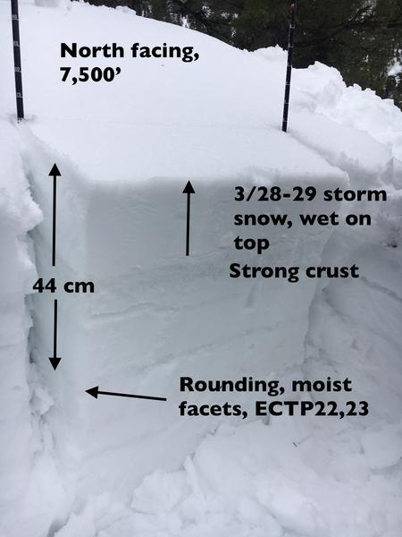
Below Photo 1: Mid/low elevation north facing (7,500') seemed ripe for wet activity if we get enough precip out of this storm. The surface inch was damp, but the rest of the Thursday/Friday storm was dry. Easy to imagine rain saturating the finer-grained snow and roller balls along with wet loose sluffs resulting. With a mix of rain and wet snow expected at this elevation, expect wet loose sluffs to be easy to trigger tomorrow, on steeper, northerly facing slopes. Sluffs could gouge down and take out the 6 to 8” of settled snow from the March 28-29 storm. Deeper weak layer with ECTP is interesting, but don’t think it will be an issue with the upcoming small storms
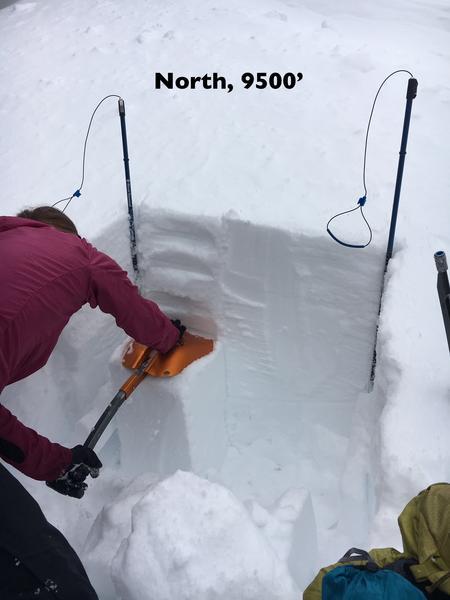
Photo 2: North facing, 9,500’ - only concern where we dug was the 8 -10 cm of slightly weak surface snow. The top couple of cm were warming, but there was still some dry cold snow beneath. With the small incoming storm, I’d expect poor bonding to the old snow surface in places, especially the higher in elevation you go with less warming. But would not expect avalanches to step down into any other layers. No results with the Extended Column Test.
Today's Observed Danger Rating
Low
Tomorrows Estimated Danger Rating
None


