Forecast for the Salt Lake Area Mountains

Drew Hardesty
Issued by Drew Hardesty for
Saturday, February 16, 2019
Areas of CONSIDERABLE DANGER exist for heavily wind loaded slopes. The danger is most pronounced on upper elevation northerly through easterly facing terrain. Non-wind drifted slopes have a MODERATE danger. Cornices are an issue - Exercise great caution along and underneath the heavily corniced ridgelines.
Safe Travel Protocols are critical: one at a time, get out of the way at the bottom, have a plan.
Low
Moderate
Considerable
High
Extreme
Learn how to read the forecast here
Special Announcements
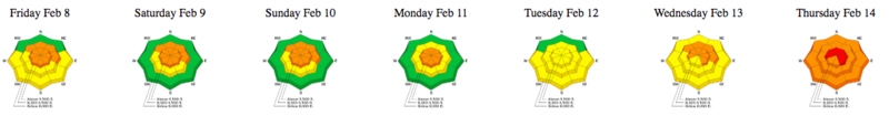
An AVALANCHE WARNING for the Uintas and the Manti-Skyline Plateau remains in effect with a HIGH avalanche danger.

The accident reports for the four avalanche fatalities are all finalized with some first-hand accounts and worth reading. We all have something to learn so that we can get home safely to our loved ones.
Jan 18 Electric Lake Accident (Skyline area)
Jan 25 Laurel Peak Accident (Moab area)
Feb 7 Circleville Mtn Accident (Southwest area near Beaver, UT)
Feb 9 Chalk Creek Accident (Western Uintas)

The latest UAC Podcast was just released: The Message and the Messengers - A Conversation with Alex Hamlin. In this podcast, we sit down with Alex Hamlin. For over fifteen years, Alex Hamlin has worked at the intersection of storytelling and outdoor sport, with experience at magazines, global retail brands and creative agencies....
Weather and Snow
Skies are overcast with light snow falling in the mountains. Skiing and riding today will be nothing short of sublime.
Overnight storm totals are 8"/0.54" in upper Little Cottonwood and 6"/0.45" in upper Big Cottonwood. The Park City areas picked up 4-6" overnight. We'll see another couple-few inches during the day today.
Winds are generally light from the west-northwest.
Temperatures are in the single digits.
It's been quite the run. Since Wednesday, snow and water amounts are
  • LCC: 30"/3.72"
  • BCC: 26"/3.64"
  • PC ridgeline: 21"/2.35"
  • Ogden: 32"/4.0"
  • Provo: 21"/3.7"

Snow depths are 110-135"+ in the upper Cottonwoods and 75-90" along the PC ridgeline. The Ogden and Provo mountains boast (and I mean boast) snow depths of 95" (and - mind you - these snow stakes are at 7500'-8000')!
Recent Avalanches
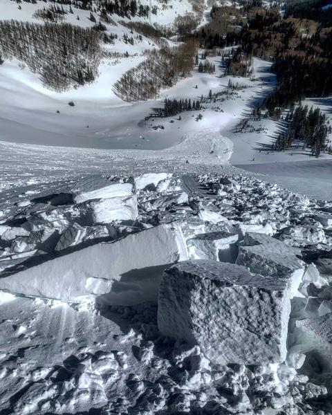
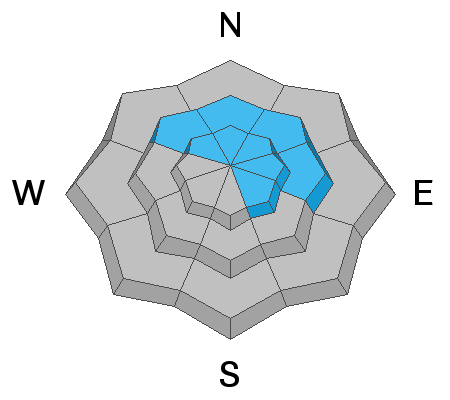
Ski area avalanche control teams triggered numerous soft and hard wind and storm snow avalanches 1-3' deep primarily on upper elevation north through easterly facing aspects. In the backcountry, we only heard about one avalanche - an intentional cornice drop in West Monitor (ENE at 10,000') triggered a 1-2' deep and 250' wide avalanche. (pc White) Minor wet loose sluffs noted down low in the canyons.
Ad
Avalanche Problem #1
Wind Drifted Snow
Type
Location
Likelihood
Size
Description
Heavily wind loaded areas are still suspect. Soft and hard wind slabs may be triggered in steep terrain today, primarily in the upper elevations on northerly through easterly aspects. They'll be challenging to recognize as they're now buried underneath 6-8" of powder. Tremper used to call it "sucker snow" for good reason as it'll lure you out onto the wind slab. These drifts are becoming increasingly stubborn, but they do have the nasty habit of pulling out on perhaps the third or fourth person down the slope, perhaps where the lens of the teardrop-shaped drift tapers small. They also like to pull out well above you. The term "unmanageable" comes to mind.
The majority of these drifts are in upper elevation northerly through easterly aspects but scattered around the compass in the mid-elevations due to terrain channeling.

CORNICES ARE ENORMOUS. Most of these are too large to intentionally drop onto a slope below. They will break back farther than you think, well back from the apex of the ridgeline. 5% of our avalanche fatalities in Utah have involved cornice fall. Exercise great caution along and underneath the heavily corniced ridgelines.
Avalanche Problem #2
New Snow
Type
Location
Likelihood
Size
Description
The low density snow will sluff on the steepest slopes today and may run naturally with any localized spike in snowfall today. Sluff management will be critical if headed into steep, sustained couloirs today. The low density smoke can easily knock you off your feet or ride and pile up deeply into gullies or other terrain traps.
Avalanche Problem #3
Persistent Weak Layer
Type
Location
Likelihood
Size
Description
Human triggered large avalanches into much older snow layering 3-6'+ deep are possible in isolated areas. In general, these avalanches probably need to be triggered by a heavy load such as multiple snowmobiles on a slope, a cornice fall, new snow avalanches stepping down to older layers, or an explosive. Or being unlucky enough in finding the thinner trigger spot in the slab. Terrain that has avalanched previously (repeater slopes) or other thinner snowpack areas are not to be trusted. Cracking and collapsing rarely play a role here. A very large natural avalanche into old snow released naturally (cornice fall?) in the upper Icebox of Main Porter Fork (9400' NE) on Thursday (est) that has been described as a 25 year event pulling out 6' deep and 500' wide, that probably left a few cords of firewood in the debris.
Additional Information
We're in luck in the powder preservation department: we'll have cloudy skies with a few more inches of snow today with cool weather and light wind through the week. The overall avalanche danger will slowly trend toward Moderate and Low in the coming days.
General Announcements
This information does not apply to developed ski areas or highways where avalanche control is normally done. This forecast is from the U.S.D.A. Forest Service, which is solely responsible for its content. This forecast describes general avalanche conditions and local variations always occur.