Forecast for the Skyline Area Mountains

Brett Kobernik
Issued by Brett Kobernik for
Thursday, April 5, 2018

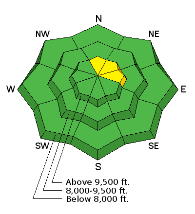
Most of the terrain along the Skyline has a LOW avalanche danger. There is a remote chance that a person could trigger an avalanche that breaks to the ground on slopes approaching 40 degrees in steepness that face north through east above about 9500' in elevation. If you avoid this terrain you will avoid avalanche danger.

Low
Moderate
Considerable
High
Extreme
Learn how to read the forecast here
Ad
Additional Information

Thursday: Mostly cloudy, with a high near 41. West wind 9 to 15 mph.
Thursday Night: A 50 percent chance of snow showers. Mostly cloudy, with a low around 26. West wind 11 to 16 mph. New snow accumulation of less than a half inch possible.
Friday: A 40 percent chance of snow showers. Mostly cloudy, with a high near 40. West northwest wind 11 to 16 mph. New snow accumulation of less than a half inch possible.
Friday Night: A slight chance of snow showers before midnight, then a chance of rain and snow showers. Mostly cloudy, with a low around 32. West wind 11 to 16 mph. Chance of precipitation is 30%. New snow accumulation of less than one inch possible.
Saturday: Rain. High near 44. Breezy. Chance of precipitation is 80%.
Saturday Night: Snow showers. Low around 24. Breezy. Chance of precipitation is 80%. Little or no snow accumulation expected.
Sunday: A chance of snow showers. Mostly cloudy, with a high near 31.

General Announcements

Support the Utah Avalanche Center through your everyday shopping. DETAILS HERE

We will publish full detailed advisories Saturday and Sunday mornings by 7am. We will also be publishing basic avalanche danger ratings & info during the week.

If you are getting out into the mountains, we love to hear from you! You can SUBMIT OBSERVATIONS ONLINE or EMAIL US

If you would like to have avalanche advisories emailed to you, SIGN UP HERE

We can provide basic avalanche awareness presentations for your school, group or club. To enquire, CLICK HERE