Avalanche Watch
THE FOREST SERVICE UTAH AVALANCHE CENTER IN SALT LAKE CITY HAS ISSUED A BACKCOUNTRY AVALANCHE WATCH.
* TIMING…IN EFFECT FROM 6 AM MST THIS MORNING TO 6 AM MST SUNDAY
* AFFECTED AREA…FOR THE MOUNTAINS OF NORTHERN UTAH INCLUDING THE WASATCH RANGE...BEAR RIVER RANGE...AND THE UINTA MOUNTAINS.
* AVALANCHE DANGER…THE AVALANCHE DANGER FOR THE WATCH AREA IS CONSIDERABLE AND IS EXPECTED TO RISE TO HIGH BY SUNDAY.
* IMPACTS…STRONG WINDS AND HEAVY SNOWFALL WILL LIKELY CREATE DANGEROUS AVALANCHE CONDITIONS BY EARLY SUNDAY, AND CONTINUING INTO MONDAY. BOTH HUMAN TRIGGERED AND NATURAL AVALANCHES ARE LIKELY. STAY OFF OF AND OUT FROM UNDER SLOPES STEEPER THAN 30 DEGREES.
BACKCOUNTRY TRAVELERS SHOULD CONSULT WWW.UTAHAVALANCHECENTER.ORG OR CALL 1-888-999-4019 FOR MORE DETAILED INFORMATION.
THIS WATCH DOES NOT APPLY TO SKI AREAS WHERE AVALANCHE HAZARD REDUCTION MEASURES ARE PERFORMED.
To get help in an emergency (to request a rescue) in the Wasatch, call 911. Be prepared to give your GPS coordinates or the run name.
If you trigger an avalanche in the backcountry, but no one is hurt and you do not need assistance, please notify the nearest ski area dispatch to avoid a needless response by rescue teams. Thanks.
Episode 6 of the UAC podcast "A Conversation with Tom Kimbrough, Hemingway of the Wasatch" is live. We explore ideas about lifetime exposure to risk and what role Buddhism has played in his life as a climber, as a skier, and as a soon-to-be octogenarian. We talk about what has changed over the years in snow science and the role of mentorship in the world of forecasting and other professions and pursuits. Check it out on ITunes, Stitcher, the UAC blog.
We have discount lift tickets for Alta, Snowbird, Brighton, Solitude, Snowbasin,and Beaver Mountain. Details and order information here. All proceeds from these go towards paying for avalanche forecasting and education!
The UAC Marketplace is still open. Our online marketplace still has deals on skis, packs, airbag packs, beacons, snowshoes, soft goods and much more.
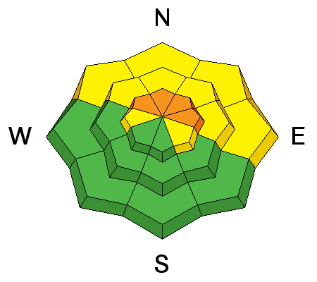
With almost identical conditions to yesterday morning, temperatures this morning are in the 20's F and winds are still howling in the Ogden area mountains with Ogden Peak averaging 50+ mph with 80 mph gusts overnight. The mountains picked up 1-3 inches of snow. The aforementioned strong winter storm system, though delayed, is now scheduled to really impact the zone overnight tonight with the potential for 1-2 feet of snow by Sunday night. Expect similar stormy conditions again today with continued strong southwest winds. Given the past 24 hours of wind damage, riding conditions are now highly variable with very sheltered, low angle slopes facing the northern part of the compass holding the best hope for any soft snow.
Ogden Peak Weather Station:

Ski area control teams reported prolific results yesterday with explosive work, releasing many hard wind slabs 1-3' deep in unopened, upper elevation terrain.
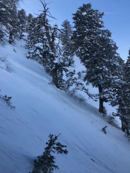
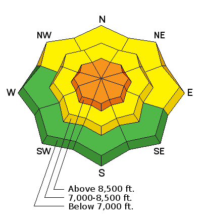
Wednesday, 2 separate slides were triggered in Hells Canyon, both at 8500', on northerly facing slopes, and running 2000' vertical feet down into the gully bottom.
Wednesday Feb. 28, Snowboard triggered slide, Hells Canyon. pc: Snowbasin patrol.