Forecast for the Skyline Area Mountains

Brett Kobernik
Issued by Brett Kobernik for
Friday, February 23, 2018

The avalanche danger is CONSIDERABLE today on steep slopes that face northwest and especially north and east above about 9500'. Human triggered avalanches are likely in this terrain. Outside of this terrain the avalanche danger is much lower and you can travel safely if you avoid being on or below the slopes mentioned.
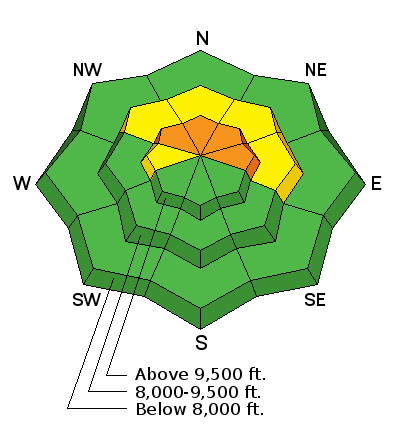
Low
Moderate
Considerable
High
Extreme
Learn how to read the forecast here
Weather and Snow

A few inches of snow fell on Thursday and a little more trickled in overnight. Temperatures dropped into the low teens and singles digits overnight.

Snow pit tests still reveal a poor snowpack structure with failure and propagation in the buried weak snow deeper in the snowpack. My partner and I also experienced a large collapse on Thursday. These observations continue to show how weak the snowpack is. Many slopes just need a little nudge to make them avalanche.

Recent Avalanches

I received a report of a snowmobile triggered avalanche in the Gooseberry area just south of I-70 that happened on Wednesday. There wasn't much detail but the person wasn't caught or injured. It sounds like it broke into old weak snow buried deeper in the snowpack. The Gooseberry area has a very similar snowpack to much of the Manti Skyline.

Ad
Additional Information

General Announcements

Support the Utah Avalanche Center through your everyday shopping. DETAILS HERE

We will publish full detailed advisories Saturday and Sunday mornings by 7am. We will also be publishing basic avalanche danger ratings & info during the week.

If you are getting out into the mountains, we love to hear from you! You can SUBMIT OBSERVATIONS ONLINE or EMAIL US

If you would like to have avalanche advisories emailed to you, SIGN UP HERE

We can provide basic avalanche awareness presentations for your school, group or club. To enquire, CLICK HERE