Forecast for the Ogden Area Mountains

Evelyn Lees
Issued by Evelyn Lees for
Wednesday, February 7, 2018

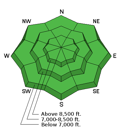
The snow is stable in most areas and avalanches are generally unlikely. But LOW danger does not mean no danger.

You might trigger cornice falls and/or shallow wind slab avalanches on drifted slopes at upper elevations. And avalanches stepping into old snow remain possible on isolated steep slopes with poor snow structure. Avoiding steep northwest through easterly facing slopes is still reccommonded.

Low
Moderate
Considerable
High
Extreme
Learn how to read the forecast here
Special Announcements

Discount lift tickets for Alta, Snowbird, Brighton, Solitude, Snowbasin,and Beaver Mountain. Details and order information here. All proceeds from these go towards paying for avalanche forecasting and education!

Weather and Snow

Under clear skies, it actually feels like winter this morning – with temperatures in the low 20s at most Ogden mountain stations this morning. Combined with brisk winds, the wind chill is close to zero this morning along the highest ridge lines. The westerly wind speeds are variable, occasionally reaching 15 to 20 mph averages, with gusts in the 30s, at the mid elevations. Mount Ogden has had 30 mph averages at times in the past 12 hours.

Ogden area mountains received up to an inch of snow in the past 48 hours.

Recent Avalanches

No recent avalanche activity has been reported from the Ogden area mountains.

Ad
Avalanche Problem #1
Persistent Weak Layer
Type
Location
Likelihood
Size
Description

Although unlikely, persistent slab avalanches remain possible on isolated steep slopes in the backcountry. Outlying shady slopes with shallow and weak snow are the most suspect, or very steep slopes, especially in gullies and canyons that remain shady all day.

  • Widespread buried faceted layers appear dormant now, and persistent slab avalanches are unlikely, but if you trigger one it could be dangerous.
  • Pay attention to possible signs of instability like cracking and whumpfing or collapsing, but remember these signs aren't always present when avalanches are triggered, so you have to dig down into the snow to find poor snow structure.
  • Continue to avoid very steep rocky slopes at upper elevations with shallow, weak snow cover.
  • It is still a good idea to avoid steep, northwest through easterly facing slopes, especially where wind drifted, so that you can avoid tirggering one of these slides.
Avalanche Problem #2
Normal Caution
Type
Location
Likelihood
Size
Description

Wind Slabs: There may be a few new and old wind slabs on upper elevation slopes, expecially those facing easterly and northerly. With minimal snow available for transport, these wind slabs should be isolated and pretty small.

Cornices: Avoid travel on and below any new and old cornices.

Additional Information

A mild northwest flow will continue over the area through Friday. Mostly clear skies this morning, with increasing clouds this afternoon. Temperatures will warm into the low 40s at 9,000’. The westerly winds will average 5 to 15 mph at the mid elevations, with the high peaks reaching averages of 25 to 35 mph at times, with gusts in the 40s. The next chance for a few inches of snow is Saturday.

General Announcements

CLICK HERE FOR MORE GENERAL INFO AND FAQ

The UAC has new support programs with Outdoor Research and Darn Tough. Support the UAC through your daily shopping. When you shop at Smith's, or online at Outdoor Research, REI, Backcountry.com, Darn Tough, Patagonia, NRS, Amazon, eBay a portion of your purchase will be donated to the FUAC. See our Donate Page for more details on how you can support the UAC when you shop.

Benefit the Utah Avalanche Center when you buy or sell on eBay - set the Utah Avalanche Center as a favorite non-profit in your eBay account here and click on eBay gives when you buy or sell. You can choose to have your seller fees donated to the UAC, which doesn't cost you a penny

This information does not apply to developed ski areas or highways where avalanche control is normally done. This advisory is from the U.S.D.A. Forest Service, which is solely responsible for its content. This advisory describes general avalanche conditions and local variations always occur.