Forecast for the Skyline Area Mountains

Brett Kobernik
Issued by Brett Kobernik on
Tuesday morning, February 6, 2018

The majority of the terrain along the Skyline still has a LOW avalanche danger. There is a MODERATE danger on slopes steeper than 35˚ and higher than 9500' that face northwest through east especially where fresh drifts have formed. You can travel safely in most of the terrain today but if you start looking for trouble on steep upper elevation slopes, there's a slight chance you might find it.
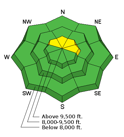
Low
Moderate
Considerable
High
Extreme
Learn how to read the forecast here
Weather and Snow

The small storm that moved through last night gave us 2 to 4 inches of snow along the Manti Skyline. West northwest wind has been in the moderate speed range along the ridges. This combination of snow and wind probably isn't enough to overload the buried weak snow near the ground and cause a widespread avalanche cycle. It might be enough to produce some isolated human triggered avalanches though. Likely spots are those upper elevation steep slopes that face northwest through east. This terrain is holding the most new wind drifted snow and also holds the weakest buried faceted sugar snow near the ground.

Ad
Additional Information

General Announcements

Support the Utah Avalanche Center through your everyday shopping. DETAILS HERE

We will publish full detailed advisories Saturday and Sunday mornings by 7am. We will also be publishing basic avalanche danger ratings & info during the week.

If you are getting out into the mountains, we love to hear from you! You can SUBMIT OBSERVATIONS ONLINE or EMAIL US

If you would like to have avalanche advisories emailed to you, SIGN UP HERE

We can provide basic avalanche awareness presentations for your school, group or club. To enquire, CLICK HERE