

Forecast for the Salt Lake Area Mountains

Saturday morning, February 3, 2018
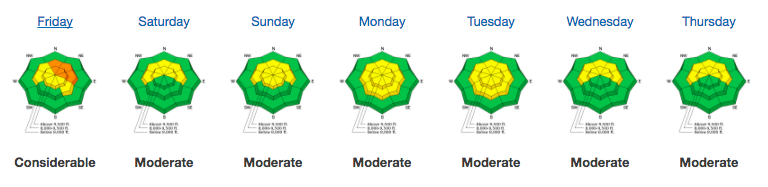
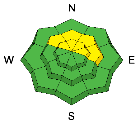
Most terrain has a LOW avalanche danger. Isolated areas of MODERATE danger, however, exist on northwest to east facing slopes above about 9000'. In this terrain, human triggered avalanches 1-3' deep are possible. Additionally, shallow pockets of soft and hard wind slab are littered across the landscape, but most problematic in high consequence terrain. Lastly, damp push-alanches are possible in steep low to mid-elevation sheltered slopes that have remained warm for the past several days.
 Special Announcements
The latest UAC podcast - "Recreating Like a Pro - A Conversation with IFMGA guide Anna Keeling" is live. This podcast will be ideal for anyone looking to pick up some tips and tricks from a professional mountain guide for recreating in the winter backcountry environment.
 Weather and Snow
Skies are overcast. Mountain temperatures are in the mid to upper 20s up high, the mid to upper 30s down low. The west-northwesterlies amped up overnight and are averaging 25-30mph with gusts to 50. 11,000' stations have hourly speeds at 40mph with gusts to 70. Even some lower elevation anemometers are gusting to 40mph. We did pick up a trace of snow yesterday, however.
For January, the Alta Guard station (8700') reported 51.5" of snow with 4.5" SWE (Snow Water Equivalent). The 74-year January average is 92"/8.6".
Year to date is 109" with 11" SWE (average YTD through January is 250" with 23.3" SWE).
Be sure to read our latest Week in Review for avalanche activity and significant mountain weather events from this past week.
 Recent Avalanches
None. See Greg's Week in Review for more info.
Persistent Weak Layer
Description
I was able to collapse and crack out a small test slope yesterday on a north facing piece of terrain at 9200'. It cracked out about 1' deep and 20' across. It wasn't particularly representative of most of our terrain and yet there it was: poor structure, additional wind loading, trigger. Collapse. The moderate to strong winds will add just a bit of extra stress to areas of poor structure. Our lingering persistent slab avalanche problem exists at elevations 9000' and above, on slopes facing northwest through east (with a particular emphasis on north through northeast.) Thinner snowpack areas are particularly suspect – such as rocky rollovers as well as terrain outside of the upper Cottonwoods.
Additional Information
By and large, we'll be under a moderate to strong northwesterly flow for the rest of time eternal. Ok at least for the next week. Expect maybe a trace to an inch of snow this weekend with perhaps 2-5" on Monday/Tuesday. The Logan and Ogden mountains may see twice that. For today, we'll have overcast skies, west-northwest winds blowing 35+mph and temps in the upper 20s along the ridgelines.
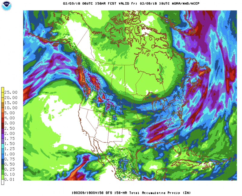
I've cherry picked one of the weather models for expected total precipitation (in SWE - Snow Water Equivalent) through next Friday. As you can see, we're clearly on the dry side of the storm track while our neighbors to the north in Idaho, Wyoming and Montana eat our lunch. Road trip anyone?
General Announcements
CLICK HERE FOR MORE GENERAL INFO AND FAQ
The UAC has new support programs with Outdoor Research and Darn Tough. Support the UAC through your daily shopping. When you shop at Smith's, or online at Outdoor Research, REI, Backcountry.com, Darn Tough, Patagonia, NRS, Amazon, eBay a portion of your purchase will be donated to the FUAC. See our Donate Page for more details on how you can support the UAC when you shop.
Benefit the Utah Avalanche Center when you buy or sell on eBay - set the Utah Avalanche Center as a favorite non-profit in your eBay account here and click on eBay gives when you buy or sell. You can choose to have your seller fees donated to the UAC, which doesn't cost you a penny
This information does not apply to developed ski areas or highways where avalanche control is normally done. This advisory is from the U.S.D.A. Forest Service, which is solely responsible for its content. This advisory describes general avalanche conditions and local variations always occur.