Observation Date
1/29/2018
Observer Name
Mark Staples
Region
Ogden » Monte Cristo » Monte Cristo Peak
Location Name or Route
North of Monte Cristo Peak
Weather
Weather Comments
Started clear and sunny - became cloudy and breezy. WARM!!
Snow Characteristics
New Snow Depth
10"
New Snow Density
Medium
Snow Surface Conditions
Powder
Snow Characteristics Comments
No rime crust in the Monte area. Powder on shaded slopes above 8000 feet is still in great shape. Good riding where you can get away from old tracks.
Avalanche Problem #1
Problem
Persistent Weak Layer
Problem #1 Comments
Two persistent weak layers to create a persistent slab avalanche problem.
Buried surface hoar - it was an obvious stripe in the snowpack about 10 inches deep.
Buried facets - weakest layer of facets was about 2 feet deep.
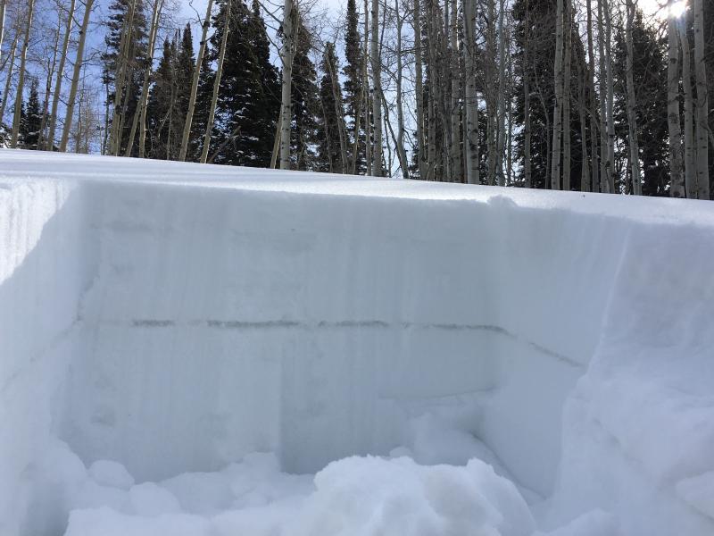
I was surprised how widespread and easy to find the buried surface hoar was (see photo below - look at the obvious stripe in the snowpit wall). It did not exist on sunny/southerly aspects where a crust exists in its place. For now it is not a problem because the 10" of snow on top of it is not cohesive enough to make an avalanche.
ALSO - This surface hoar does not exists in any of the high traffic areas like all over Monte Cristo Peak. Skiers, expert snowmobilers, and snowbikers who venture away from these compacted areas will need to looking for this layer when the next storm comes.
Snow Profile
Aspect
North
Elevation
8,900'
Slope Angle
23°
Comments
The snowpack is becoming much more supportable.
However, plenty of weak snow exists in the snowpack. There's a difference between weak and unstable. Layers in the snowpack are weak becase the individual crystals are poorly bonded to each other.
The snowpack is not necessarily unstable until it gets a load. It will become unstable again when it gets a load of new snow or wind-blown snow. Right now it is mostly stable but there are possiblye a few booby traps out there.
Video
Today's Observed Danger Rating
Moderate
Tomorrows Estimated Danger Rating
Moderate
Coordinates