Forecast for the Skyline Area Mountains

Brett Kobernik
Issued by Brett Kobernik for
Saturday, January 27, 2018

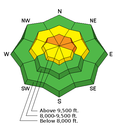
The avalanche danger is CONSIDERABLE on steep slopes above about 9500' that face northwest, north and east. Human triggered avalanches are likely in this terrain today and Sunday. You can safely travel around if you stay on slopes less than 30˚ in steepness as well as staying out from underneath steep slopes.

Low
Moderate
Considerable
High
Extreme
Learn how to read the forecast here
Special Announcements

We are offering a Motorized Backcountry 101 avalanche class on February 10th. DETAILS HERE

Weather and Snow

The recent storm on Thursday night gave us 3 to 7 inches of new snow along the Skyline. There was some strong southwest wind prior to the storm but wind slowed and the fresh powder remains fairly untouched by the wind. Skies were starting to clear late on Friday. Overnight, temperatures dropped into the teens and west northwest wind has stayed fairly light.

Recent Avalanches

My partner and I did not see any evidence of natural activity from the storm and no avalanches were reported from Friday.

However, there were some snowmobile triggered avalanches on Wednesday. See the links below.

01/24/2018 Skyline region: Avalanche: Petes Hole, Snowmobiler trigger - 3' deep - 125' wide
01/24/2018 Southwest region: Avalanche: Niotche Creek, Snowmobiler trigger

Ad
Avalanche Problem #1
Persistent Weak Layer
Type
Location
Likelihood
Size
Description

Sorry, I'm going to sound like a broken record for a while. DO NOT TRUST STEEP SLOPES ON THE NORTH HALF OF THE COMPASS. We have weak snow near the ground which is sensitive and is causing avalanches. Not everything you touch is going to avalanche. It might be the 4th or 10th person on a slope before it releases. You might hit some steep slopes without triggering anything which gives you confidence and then the next slope avalanches on you. What I'm saying is that this is an unpredictable situation. What we know is that buried faceted (sugar) snow is what kills the majority of people in avalanches in Utah and we know there is a lot of buried faceted snow along the Skyline. Your only defense is to stay on low angle slopes or slopes where YOU KNOW there is no old faceted snow near the ground.

Additional Information

We'll see mostly clear skies today with ridge top high temperatures getting into the mid 20s. Wind will start out from the southwest and veer to the northwest in the afternoon. It will be fairly light early in the day and increasing a bit later most notably along the ridge tops and not so much in the canyon bottoms. High pressure builds in through early next week with gradually warming temperatures each day, partly cloudy skies and generally light wind.

General Announcements

Support the Utah Avalanche Center through your everyday shopping. DETAILS HERE

We will publish full detailed advisories Saturday and Sunday mornings by 7am. We will also be publishing basic avalanche danger ratings & info during the week.

If you are getting out into the mountains, we love to hear from you! You can SUBMIT OBSERVATIONS ONLINE or EMAIL US

If you would like to have avalanche advisories emailed to you, SIGN UP HERE

We can provide basic avalanche awareness presentations for your school, group or club. To enquire, CLICK HERE