Join us at our 2nd Annual Blizzard Ball

Forecast for the Provo Area Mountains

Trent Meisenheimer
Issued by Trent Meisenheimer on
Sunday morning, December 24, 2017

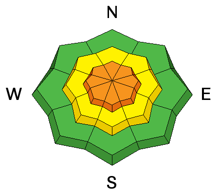
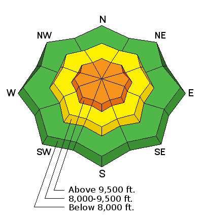
Today there is a CONSIDERABLE avalanche danger on all upper elevation terrain for wind slab and persistent slab avalanches. These dangerous avalanche condition require careful snowpack evaluation, cautious route finding and conservative decision-making skills. Natural avalanches are possible and human triggered avalanches likely. Avoid being on, adjacent or under steep slopes as avalanches can be triggered from a distance.

At mid elevations the danger will be MODERATE for triggering a wind slab. The best and safest riding will be found on low angle terrain (less than 30 degrees) with nothing steep above or adjacent to you.
Low
Moderate
Considerable
High
Extreme
Learn how to read the forecast here
Avalanche Watch

THE FOREST SERVICE UTAH AVALANCHE CENTER IN SALT LAKE CITY HAS ISSUED A BACKCOUNTRY AVALANCHE WATCH.

* TIMING…IN EFFECT FROM 0600 MST THIS MORNING TO 0600 MST Monday.

* AFFECTED AREA…FOR THE MOUNTAINS OF NORTHERN UTAH INCLUDING THE WASATCH RANGE...OGDEN AREA MOUNTAINS...BEAR RIVER RANGE...WESTERN UINTA MOUNTAINS...

* AVALANCHE DANGER…THE AVALANCHE DANGER FOR THESE AREAS WILL BE RISING AND COULD REACH HIGH WITHIN THE NEXT 24 HOURS. SNOWFALL TONIGHT WILL POTENTIALLY MAKE VERY DANGEROUS AVALANCHE CONDITIONS.

* IMPACTS…ADDITIONAL HEAVY SNOW COMBINED WITH WIND COULD CREATE WIDESPREAD AREAS OF UNSTABLE SNOW. BOTH HUMAN TRIGGERED AND NATURAL AVALANCHES WILL BECOME LIKELY. STAY OFF OF AND OUT FROM UNDER SLOPES STEEPER THAN 30 DEGREES.

THIS WARNING DOES NOT APPLY TO SKI AREAS WHERE AVALANCHE HAZARD REDUCTION MEASURES ARE PERFORMED.

Special Announcements

Don’t know what to buy your favorite skier for Christmas? Discount lift tickets for Alta, Snowbird, Brighton, Solitude, Deer Valley, Snowbasin,and Beaver Mountain are now available, donated by the resorts to benefit the Utah Avalanche Center. Details and order information here. All proceeds from these great holiday gifts go towards paying for avalanche forecasting and education!

Weather and Snow

Old man winter finally showed its face yesterday with a ferocious storm laying down 6" to 12" inches of snow (0.34"-1.0" H20) in the Provo area mountains. The north-west winds raged for much of the day, at almost all elevations.

This morning the storm has exited to our east and we have clear skies and very cold temperatures. Upper and mid elevation temperatures are in the low teens and winds are light at the Provo area mountain weather stations. To the north, at the higher elevation stations, winds continue to be annoying from the WNW with speeds 10-20 mph gusting into the 30's along the highest ridges. Riding and turning conditions will be five stars out of five... at least for this year.

Snow totals below:

  • Upper LCC 12" (1.01" H20)
  • Upper BCC 17" (1.05" H20)
  • Park City ridge line 13" (0.90" H20)
  • Provo 6" to 12" (0.34" - 1.0" H20)
Recent Avalanches

Natural and human triggered avalanches were reported by many backcountry riders and snow safety teams to the north yesterday as the storm snow piled up in addition to cracking and collapsing (whoophing noises) on a wide variety of aspects and elevations. Here is a list of the more notable avalanches from our northerly neighbors yesterday. All these slides were on upper elevation northerly facing terrain. This is a good indication of what you could expect in the Provo area if getting into the upper elevation north facing terrain.

  • Twin Lakes Pass (remotely triggered) 18" deep 80' wide running 300' feet down the slope failing on weak sugary (faceted) snow. Observation link: here
  • Upper LCC (remotely triggered) 18" deep 150' wide running 200' feet down the slope failing on weak sugary (faceted) snow. Observation link: here
  • Pioneer Peak, Main Chute was reported as a large natural avalanche failing on sugary (faceted) and was large enough to break tress and ran to the flats. Observation link: here
  • During my field day yesterday in Days Fork, I was able to trigger five different avalanches from a distance - all in the range of 18" deep by 150' wide, running into the flats below. All failed on weak sugary (faceted) snow. See persistent slab for a photo.

Here is a link to all the observations from yesterday. All observations.

Ad
Avalanche Problem #1
Wind Drifted Snow
Type
Location
Likelihood
Size
Description

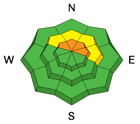
Yesterday's strong northerly winds created wind slabs on all upper elevation terrain, including well off the ridgelines and areas where the wind cross loaded snow into gullies. This morning winds continue to be from the WNW in the 15-20 mph range, gusting into the 30's at upper elevations. Winds are expected to switch to the southwest later this morning and increase as another storm approaches northern Utah. There is abundant powder snow available for transport at the upper elevations, so new sensitive wind drifts will build and become easy to trigger today.

Wind can change the landscape and increase the avalanche danger faster than any other weather factor, so be alert to the changing conditions and reevaluate often. Natural avalanches are possible today, so be aware of what’s above you even when you are in wind-sheltered terrain. Plumes off the peaks, cracking of denser snow or your tracks filling in are key signs of wind drifting.

Out of wind effected terrain it is possible to trigger a storm slab failing on last Wednesday's storm snow. Many observers were seeing full propagation in their snowpit tests on this layer of low density stellars. It's complicated - avoid all avalanche terrain today and stick to low angle slopes that aren't steeper than 30 degrees to enjoy the new snow.

Avalanche Problem #2
Persistent Weak Layer
Type
Location
Likelihood
Size
Description

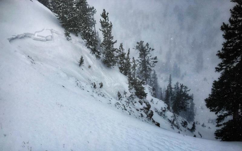
Any new snow avalanches in upper elevation northwest through east facing terrain may step down to the weak sugary facets. These slides will likely be 1-2' deep and a few hundred feet wide and may be un-survivable. Avalanches can be triggered from a distance today, so avoid being on, adjacent, or under any terrain steeper than 30 degrees. This storm was a good test to see how our weak sugary snowpack reacted under stress. Your weight will be additional stress today if entering the upper elevation steep northerly terrain, where I would bet you'll trigger an avalanche.

Photo: Trent Meisenheimer, field day along the Days Fork ridgeline in the Wasatch area. This is a good example of the terrain we want to avoid today. You could expect to find this type of avalanche in the upper elevation northwesterly through east facing terrain in the Provo area.

Additional Information

Increasing clouds today as a storm approaches northern Utah. Temperatures will rise into the mid to upper 20's Fahrenheit by this afternoon. Winds are expected to shift to the southwest with speeds in the 15-20 mph range gusting into the 30's along the upper elevation ridgelines. A cold front will arrive overnight and into Monday bringing a white Christmas and hopefully 2" to 6" inches of new snow.

General Announcements

FOR MORE GENERAL INFORMATION AND FAQ, CLICK HERE

Support the UAC through your daily shopping. When you shop at Smith's, or online at REI, Backcountry.com, Patagonia, NRS, Amazon, eBay a portion of your purchase will be donated to the FUAC. See our Donate Page for more details on how you can support the UAC when you shop.

Benefit the Utah Avalanche Center when you buy or sell on eBay - set the Utah Avalanche Center as a favorite non-profit in your eBay account here and click on eBay gives when you buy or sell. You can choose to have your seller fees donated to the UAC, which doesn't cost you a penny

This information does not apply to developed ski areas or highways where avalanche control is normally done. This advisory is from the U.S.D.A. Forest Service, which is solely responsible for its content. This advisory describes general avalanche conditions and local variations always occur.