Forecast for the Skyline Area Mountains

Brett Kobernik
Issued by Brett Kobernik for
Sunday, April 9, 2017

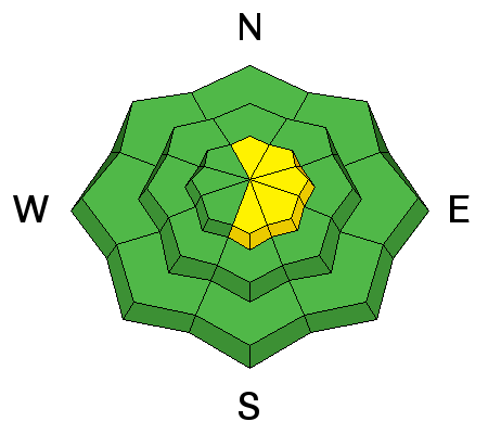
The avalanche danger is generally LOW today. However, there is a MODERATE danger for triggering a fresh wind slab along the upper elevation ridges. Watch for cracking and avoid any obvious fresh drifts of wind blown snow.

Low
Moderate
Considerable
High
Extreme
Learn how to read the forecast here
Weather and Snow

Despite quite warm temperatures on Saturday, the snow did not warm up much above 9500 feet. A quick snow flurry moved through early in the morning but did not add more than a trace of snow. Southwest wind was strong all day. A cold front moved through overnight which left us with 2 to 4 inches of new snow. Wind veered to the northwest and is still pretty strong. Temperatures dropped into the teens along the higher terrain.

Ad
Avalanche Problem #1
Wind Drifted Snow
Type
Location
Likelihood
Size
Description

The strong wind most likely formed some deeper drifts that might crack out on a person today along the higher ridges. These won't be huge avalanches but might be enough to take a person off guard. I would expect some fresh cornices have formed also.

Additional Information

We should see skies clearing as the day goes on with ridgetop high temperatures only into the upper 20s. Northwest wind will start to slow around noon. Temperatures stay fairly cool on Monday then we'll see a warming trend Tuesday and Wednesday.

General Announcements

We will publish full detailed advisories Saturday and Sunday mornings by 7am. We will also be publishing basic avalanche danger ratings & info during the week.

If you are getting out into the mountains, we love to hear from you! You can SUBMIT OBSERVATIONS ONLINE or EMAIL US

If you would like to have avalanche advisories emailed to you, SIGN UP HERE

We can provide basic avalanche awareness presentations for your school, group or club. To enquire, CLICK HERE