Forecast for the Abajo Area Mountains

Wednesday morning, January 11, 2017
The avalanche danger is MODERATE today on steep, upper elevation slopes that have a NW-E-SE aspect. Suspect the lee sides of ridge crests and terrain features such as sub ridges and gully walls. Avoid steep slopes with recent deposits of wind drifted snow. Out of the wind zone at mid and lower elevations the danger is mostly LOW.
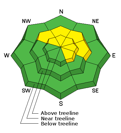
Special Announcements
The Abajo/Blue Mountain avalanche advisory will provide detailed information on the weekends. During the week, general information and a danager rating will be posted.
Weather and Snow
For real time weather data click on the links below:
Winds, temperature and humidity on Abajo Peak.
Snow totals at Camp Jackson.
Additional Information
Today
A 50 percent chance of snow. Mostly cloudy, with a high near 29. Windy, with a west southwest wind 25 to 30 mph, with gusts as high as 50 mph. Total daytime snow accumulation of less than a half inch possible.
Tonight
Snow likely, mainly after 4am. Mostly cloudy, with a low around 22. Breezy, with a west wind 20 to 25 mph, with gusts as high as 35 mph. Chance of precipitation is 70%. New snow accumulation of around an inch possible.
Thursday
Snow. High near 27. Breezy, with a south wind 20 to 25 mph. Chance of precipitation is 80%. New snow accumulation of 4 to 8 inches possible.
Thursday Night
Snow. Low around 22. Breezy, with a south southwest wind 20 to 25 mph. Chance of precipitation is 90%. New snow accumulation of 6 to 10 inches possible.
Friday
Snow. High near 29. South wind around 15 mph. Chance of precipitation is 80%.