Forecast for the Skyline Area Mountains

Brett Kobernik
Issued by Brett Kobernik for
Thursday, December 15, 2016

The majority of the terrain has a LOW avalanche danger. A MODERATE avalanche danger exists along the higher, steepest, most exposed ridges and peaks where a person could trigger a fresh wind drift. ANTICIPATE THE AVALANCHE DANGER TO RISE FRIDAY AND SATURDAY WITH THE NEXT STORM.
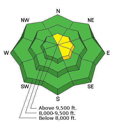
Low
Moderate
Considerable
High
Extreme
Learn how to read the forecast here
Special Announcements

THE FREE AVALANCHE PRESENTATION TONIGHT AT BIG PINE HAS BEEN RESCHEDULED FOR JAN 12 AT 6:30PM. THERE WILL BE NO PRESENTATION TONIGHT.https://utahavalanchecenter.org/observations/28723

CLICK HERE FOR DETAILS

Weather and Snow

1 to 2 inches of snow fell early Wednesday morning. Temperatures were quite warm making the snow surface damp and heavy up to around 9500 feet on all aspects.

HERE is an observation from the MIller Flat/Huntington Canyon zone from Wednesday.

Ad
Additional Information

A warm and windy storm in southwest flow will move in late Thursday and linger through Friday night. Snow levels will be about 8000' to start and dropping as the storm moves through. It's looking like 6 to 11" of new snow should fall.

General Announcements

We will publish full detailed advisories Saturday and Sunday mornings by 7am. We will also be publishing basic avalanche danger ratings & info during the week.

If you are getting out into the mountains, we love to hear from you! You can SUBMIT OBSERVATIONS ONLINE or EMAIL US

If you would like to have avalanche advisories emailed to you, SIGN UP HERE

We can provide basic avalanche awareness presentations for your school, group or club. To enquire, CLICK HERE