Forecast for the Skyline Area Mountains

Thursday morning, December 1, 2016
Most of the terrain has a LOW to MODERATE avalanche danger. Use caution in the highest more east facing terrain where recent wind drifted snow may still be unstable and could avalanche.
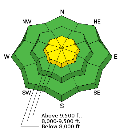
Weather and Snow
Skyline 20161130 from Brett Kobernik on Vimeo.
Recent Avalanches
No significant recent avalanche activity has been observed or reported.
Additional Information
STATE WEATHER SYNOPSIS...A weak storm system will bring light snow to portions of northern and central Utah through tomorrow as it slowly crosses the region. Strong winds may develop outside of the St George area later tonight through Saturday morning. A stronger and colder storm system will impact the region early next week.
Thursday: Snow showers likely. Mostly cloudy, with a high near 17. Wind chill values as low as -6. West wind 11 to 16 mph. Chance of precipitation is 60%. New snow accumulation of around an inch possible.
General Announcements
We will publish full detailed advisories Saturday and Sunday mornings by 7am. We will also be publishing basic avalanche danger ratings & info during the week.
If you are getting out into the mountains, we love to hear from you! You can SUBMIT OBSERVATIONS ONLINE or EMAIL US
If you would like to have avalanche advisories emailed to you, SIGN UP HERE
We can provide basic avalanche awareness presentations for your school, group or club. To enquire, CLICK HERE