Forecast for the Moab Area Mountains

Tuesday morning, November 22, 2016
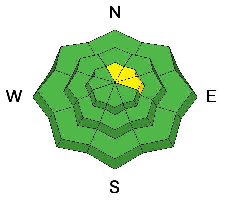
Overall the avalanche danger is LOW with a shallow and well anchored snowpack. But 16" of new snow is significant, and there may be isolated instabilities on steeper, less anchored terrain, primarily on upper elevation slopes that have a N-NE-E aspect. In these areas, you may also encounter recent deposits of wind drifted snow. Even a small slide triggered in these areas could take you for a nasty, bumpy ride over rocks.

Special Announcements
I'll be meeting with Grand County Roads today to coordinate plowing for the season. The Forest Service has installed a gate on the Geyser Pass road which will be closed when plowing is in progress. I will get up to the mountains on Wednesday and publish a detailed advisory Thanksgiving morning. What follows is my best estimation of what is going on up there.
Weather and Snow
Things have really turned around and it's just about game on. The mountains received 16" of new snow on top of around 6" that remained on the ground from last Thursday's storm. The new snow came in warm and wet with temperatures right around freezing and then things began to slowly began to cool off. The perfect scenario. Southerly winds blew in the 15-25 mph range before dropping off and shifting to westerly and then northwesterly. They've been on the increase since about 5:00 a.m. and are currently in the 20-25 mph range from the NW. It's currently 27 degrees at the Geyser Pass Trailhead and 17 on Pre Laurel Peak.
Temperature, humidity and storm totals in Gold Basin.
Temperature and base depth at the Geyser Pass Trailhead.
Winds, temperature, and humidity on Pre Laurel Peak.
New Snow


Description
Generally speaking I expect the new snow to have bonded fairly well with the 6" of existing snow that came in last Thursday. Thursday's snow fell on basically dry ground, and mountain temperatures have been warm since then. The snowpack is also still quite shallow, and rocks and brush are keeping things well anchored. Nevertheless, we just received a significant amount of snow and there may be some instabilities on less anchored slopes, primarily at upper elevations, that will take a day or so to settle out.
Wind Drifted Snow


Description
Winds have blown just enough that there may be isolated drifts on the lee sides of ridge crests and terrain features on upper elevation, N-NE-E aspects. I wouldn't be riding in these areas due to lack of coverage, but if you found yourself up there, and managed to trigger a small pocket, you could take a nasty and bumpy ride over some rocky terrain. Look for the usual tell tale signs - smooth rounded deposits of wind drifted snow or cracking in the snow surface.
Additional Information
Today
A chance of snow before noon, then a slight chance of snow showers between noon and 4pm. Partly sunny, with a high near 29. Northwest wind 10 to 15 mph. Chance of precipitation is 40%.
Tonight
Mostly clear, with a low around 23. West northwest wind 10 to 15 mph becoming southwest after midnight.
Wednesday
A 10 percent chance of snow after 11am. Mostly sunny, with a high near 33. South southwest wind 10 to 15 mph, with gusts as high as 30 mph.
Wednesday Night
A 20 percent chance of snow. Mostly cloudy, then gradually becoming mostly clear, with a low around 17. Breezy, with a southwest wind 15 to 20 mph becoming north northwest after midnight. Winds could gust as high as 35 mph.
Thanksgiving Day
Sunny, with a high near 28. North northwest wind 5 to 10 mph.
Thursday Night
Mostly clear, with a low around 19.
Friday
Sunny, with a high near 34.
Friday Night
Mostly clear, with a low around 25.
Saturday
Mostly sunny, with a high near 35.
Saturday Night
A slight chance of snow. Mostly cloudy, with a low around 18.