Sign Up for the Utah Snow and Avalanche Workshop (USAW) on December 7th!

Forecast for the Moab Area Mountains

Eric Trenbeath
Issued by Eric Trenbeath on
Sunday morning, March 13, 2016

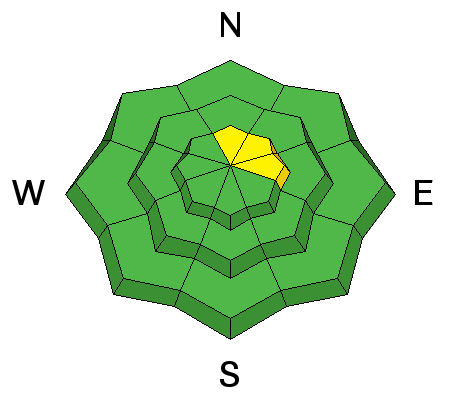
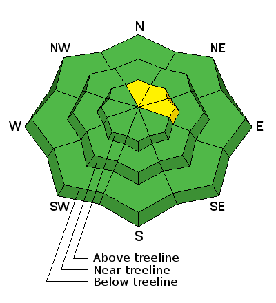
The avalanche danger is mostly LOW at this time. But low danger means that problems may still exist on isolated terrain features. You may still find isolated wind slabs, or deeper persistent slabs on steep, upper elevation, northerly aspects. If the sun stays out for an extended period, you will need to watch for loose wet slides on sun exposed slopes.

Low
Moderate
Considerable
High
Extreme
Learn how to read the forecast here
Special Announcements

Confused about danger ratings and how to apply them to your terrain choices? Check out this great video produced by the USFS National Avalanche Center.

Weather and Snow

Skies are clear this morning and overnight low temperatures have been in the low to mid 20's. Northwest winds on Pre Laurel Peak have dropped into the single digits. We should see clouds moving in later today as a storm sytem tracks through to the north.

A mixed bag of spring conditions exist of including breakable sun crusts, sloppy wet snow, and dry settled powder on sheltered, shady aspects. I did get a report yesterday from the intrepid Reed Kennard, of supportable corn snow on a sheltered, south facing slope just below treeline.

Base depth in Gold Basin: 66"

Winds, temperature and humidity on Pre-Laurel Peak

New snow totals, temperature and humidity in Gold Basin

Total snow depth and temperature at Geyser Pass Trailhead

Ad
Avalanche Problem #1
Normal Caution
Type
Location
Likelihood
Size
Description

The avalanche danger is mostly low at this time. But low danger doesn't mean no danger, and problems may still exist on isolated terrain features. Here are a few problems to remain aware of:

Wind Slabs: Isolated wind slabs may still exist on the lee sides of ridge crests and terrain features in upper elevation, wind exposed terrain, primarily on slopes with a N-NE-E aspect.

Persistent Slabs: It may still be possible to trigger a slab on weak sugary, faceted snow in areas of steep, rocky, and more extreme northerly facing terrain. Slide paths that are repeat runners are also suspect.

Loose Wet: If the sun comes out and slopes heat up, the danger remains for loose wet slide activity on sun exposed slopes.

Additional Information

A storm system tracking to the north will bring us increasing cloudy skies today and a chance for snow tomorrow.

Today

Isolated snow showers after 5pm. Partly sunny, with a high near 29. Windy, with a north northwest wind 5 to 10 mph becoming southwest 20 to 30 mph. Winds could gust as high as 40 mph. Chance of precipitation is 10%.

Tonight

A 30 percent chance of snow showers, mainly after 5am. Mostly cloudy, with a low around 22. Windy, with a west southwest wind around 30 mph, with gusts as high as 45 mph.

Monday

A 50 percent chance of snow showers. Partly sunny, with a high near 30. Very windy, with a west southwest wind 30 to 35 mph increasing to 40 to 45 mph in the afternoon. Winds could gust as high as 60 mph. New snow accumulation of around an inch possible.

Monday Night

A 50 percent chance of snow. Mostly cloudy, with a low around 14. Windy, with a west northwest wind 30 to 35 mph decreasing to 25 to 30 mph in the evening. Winds could gust as high as 55 mph. New snow accumulation of less than a half inch possible.

Tuesday

A 20 percent chance of snow. Mostly sunny, with a high near 22. Windy, with a west northwest wind 20 to 30 mph.

General Announcements

Road Conditions: The road is a mix of dirt at lower elevations that turns to mud as the day progresses. It is snowpacked higher up.

To post an observation go here. You can view Moab observations here. You can also give me a call on my cell phone at 801-647-8896

To receive this advisory by email go here.

This information does not apply to developed ski areas or highways where avalanche control is normally done. This advisory is from the U.S.D.A. Forest Service, which is solely responsible for its content. This advisory describes general avalanche conditions and local variations always exist.