Forecast for the Abajo Area Mountains

Eric Trenbeath
Issued by Eric Trenbeath for
Saturday, January 23, 2016

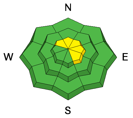
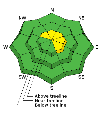
The avalanche danger is isolated or MODERATE on steep slopes that face NW-N-SE. In theses areas, it is possible for the additional weight of a rider to cause a deep and dangerous avalanche releasing on buried weak snow. Suspect gullies and terrain that is heavily featured with steep roll overs and convexities.

Elsewhere, the avalanche danger is generally LOW.

Low
Moderate
Considerable
High
Extreme
Learn how to read the forecast here
Special Announcements

The Abajo / Blue Mountain advisory provides detailed snow and avalanche information on weekends, with a general danger rating during the week.

Weather and Snow

It's been two weeks since the last storm and the snow surface is tired and worn. Snow depth varies from 3-4' deep depending on elevation throughout the range, but some wind and sun exposed slopes have been stripped back down to near the ground. Soft snow still remains on sheltered, northerly aspects.

Winds on Abajo Peak this morning are averaging 15-20 mph with gusts near 30 from the southwest. It's 26 degrees up there and 31 at Buckboard Flat.

Winds, temperature and humidity on Abajo Peak.

Snow totals at Buckboard Flat.

A tired and worn snow surface. We need some new snow!

Recent Avalanches

These slides are two weeks old from the storm of Jan 8, but I finally got far enough in to observe them. They are on southeast facing Jackson Ridge, and look to have broke between 2-3' deep, and ran for close to 1000'. With the current snowpack structure, we'll likely see activity like this again if we get another significant storm with a foot or more of snow.

Avalanche Problem #1
Persistent Weak Layer
Type
Location
Likelihood
Size
Description

The current snowpack structure is very weak. Early season snows have turned into a sugary mess at the bottom of the snowpack. We call this sugary snow near the ground depth hoar, and these weak crystals make an unstable base for a load of snow. There are also a couple of weak layers of faceted snow at mid levels in the snowpack, and just below the surface. These can become sliding surfaces when a snow load or the weight of a rider is applied.

The snowpack is currently mostly stable, but very weak, and their remains an isolated possibility for a rider to trigger an avalanche down to the sugary, depth hoar at the ground. This problem exists on steep slopes with north through easterly facing aspects. Be particularly suspicious of slopes with steep convexities or blind break overs.


This snowpit was dug on an east facing slope near North Creek Pass. Note the very weak, sugary depth hoar at the bottom of the snowpack. The depth here is 54" Stabilty tests produced a failure on this ground level, weak snow.

Additional Information

Today

Mostly cloudy, with a high near 35. Breezy, with a southwest wind 15 to 20 mph, with gusts as high as 30 mph.

Tonight

A 40 percent chance of snow after 4am. Areas of blowing snow after 4am. Cloudy, with a low around 18. Breezy, with a southwest wind around 20 mph.

Sunday

Snow. High near 24. Blustery, with a west southwest wind 15 to 20 mph becoming north northwest 20 to 25 mph in the afternoon. Winds could gust as high as 40 mph. Chance of precipitation is 80%. New snow accumulation of 3 to 5 inches possible.

Sunday Night

A 50 percent chance of snow. Mostly cloudy, with a low around 13. Blustery, with a north northwest wind 20 to 25 mph, with gusts as high as 40 mph. New snow accumulation of less than one inch possible.

Monday

A 10 percent chance of snow before 11am. Mostly sunny, with a high near 21. Blustery, with a north wind 15 to 20 mph.

General Announcements

This advisory is from the U.S.D.A. Forest Service, which is solely responsible for its content. This advisory describes general avalanche conditions and local variations always exist.