Check Out Our Holiday Auction!

Forecast for the Skyline Area Mountains

Brett Kobernik
Issued by Brett Kobernik on
Sunday morning, December 13, 2015

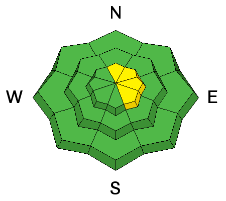
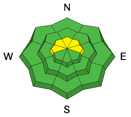
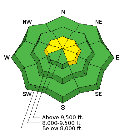
The avalanche danger is MODERATE today along the higher elevation more east facing terrain where wind may be drifting snow and creating small drifts. Small human triggered avalanches are possible today. THE AVALANCHE DANGER WILL INCREASE MONDAY AND TUESDAY WITH THE ANTICIPATED STORM.

Low
Moderate
Considerable
High
Extreme
Learn how to read the forecast here
Avalanche Watch

THE FOREST SERVICE UTAH AVALANCHE CENTER IN SALT LAKE CITY HAS ISSUED A BACKCOUNTRY AVALANCHE WATCH.

* TIMING...STARTING MONDAY MORNING, DANGEROUS AVALANCHE CONDITIONS ARE EXPECTED OVER THE NEXT SEVERAL DAYS.

* AFFECTED AREA...ALL THE MOUNTAINS OF NORTHERN AND CENTRAL UTAH, INCLUDING THE BEAR RIVER RANGE, THE WESTERN UINTAS AND THE WASATCH PLATEAU.

* AVALANCHE DANGER...THE DANGER IS EXPECTED TO RISE SIGNIFICANTLY WITH THE ADDITIONAL SNOW AND WIND.

* IMPACTS...DANGEROUS HUMAN TRIGGERED AVALANCHES ARE EXPECTED ON A VARIETY OF ASPECTS AND ELEVATIONS.

Weather and Snow

The northwest wind picked up on Saturday into the moderate speed category drifting some snow but not an alarming amount. It is still out of the northwest in most areas with gusts into the 20mph range. Along SR31 at the top of Fairview Canyon the wind is from the southwest with gusts into the 20s. Temperatures are in the mid teens and we have mostly clear skies.

Avalanche Problem #1
Wind Drifted Snow
Type
Location
Likelihood
Size
Description

The wind drifting the newest snow into sensitive drifts will be your biggest concern today. This is probably not going to be a huge issue today but continue to pay attention if you see any drifting snow. Watch the more east facing ridges and terrain features as these are the most likely spots to find a fresh drift that might crack out and release. We may see the wind increase a bit during the day today.

wind slab from Trent Meisenheimer on Vimeo.

Avalanche Problem #2
Persistent Weak Layer
Type
Location
Likelihood
Size
Description

All of the early season snow on the west, north and east facing slopes has become very weak. Any snow that builds up on top of this weak layer could cause slab avalanches. This problem is going to make the avalanche danger increase during the next storm Monday and Tuesday when we are expecting more snow.

Additional Information

We'll have increasing clouds and high temperatures up near 30 today. Winds will be blowing in the moderate speed category and may increase slightly. They will be from the northwest and should start to shift more southwest late in the day. A storm will move through starting tonight and lingering into Tuesday. Snowfall should start Monday morning and last through the day. We are expecting the snow to contain .5" to 1" of water. This should give us 6 to 12 inches of snow or perhaps a bit more if we're lucky.

General Announcements

We will publish full detailed advisories Saturday and Sunday mornings by 7am. We will also be publishing basic avalanche danger ratings & info during the week.

If you are getting out into the mountains, we love to hear from you! You can SUBMIT OBSERVATIONS ONLINE or EMAIL US

If you would like to have avalanche advisories emailed to you, SIGN UP HERE

We can provide basic avalanche awareness presentations for your school, group or club. To enquire, CLICK HERE