


Forecast for the Skyline Area Mountains

Sunday morning, March 8, 2015
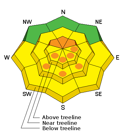
Dangerous avalanche conditions exist in the upper elevation more northerly terrain where large avalanches are likely to be triggered by people. Avoid the higher more northerly facing terrain. Some east facing slopes are suspect as well. Wet avalanche activity may also happen today with the sun heating the new snow on the sunny aspects. Get off of steep slopes as they become wet and don't linger below steep slopes or in gullies.
 Special Announcements
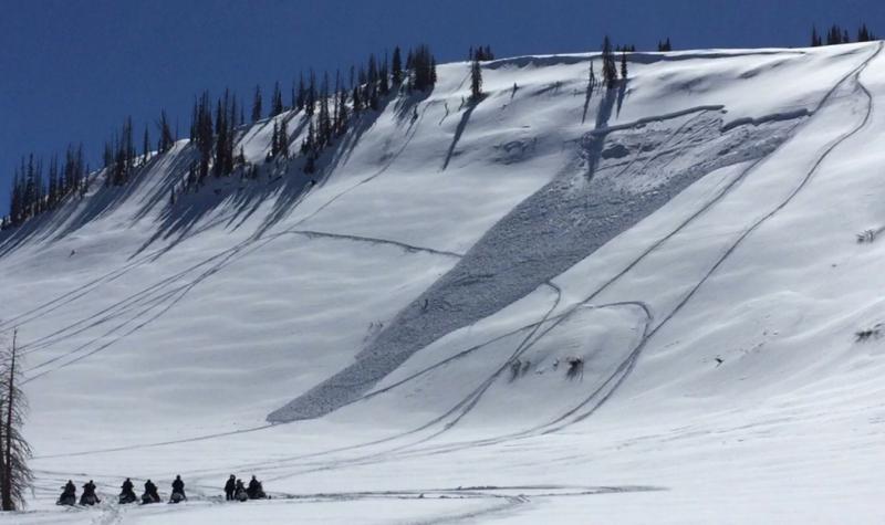
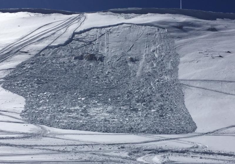
Updated to include all of the avalanches that were reported over the last week including two new snowmobile triggered avalanches in Rolfson on Saturday:
| Date | Region | Place | Trigger | Depth | Width | Aspect | Elevation | Weakness | |
|---|---|---|---|---|---|---|---|---|---|
| 03/7/2015 | Skyline | Rolfson | Snowmobiler | 2.5' | 100 | Northeast | 10200 | Facets | Details |
| 03/7/2015 | Skyline | Rolfson | Snowmobiler | 2.5' | 200 | Northeast | 10200 | Facets | Details |
| 03/4/2015 | Skyline | Skyline Summit | Snowmobiler | 3' | 150 | Northeast | 10000 | New Snow/Old Snow Interface | Details |
| 03/4/2015 | Skyline | Spring City Canyon | Skier | 2.5' | 250 | Northeast | 10300 | Facets | Details |
| 03/3/2015 | Skyline | Pleasant Creek | Snowmobiler | 20" | 80 | North | 9200 | Facets | Details |
| 03/3/2015 | Skyline | Seeley Creek | Natural | 2.5' | 400 | North | 10800 | Facets | Details |
| 03/3/2015 | Skyline | Jordan Canyon | Natural | 2' | 300 | Northeast | 10600 | Facets | Details |
| 03/3/2015 | Skyline | Blue Slide Fork | Natural | 2' | 50 | North | 10200 | Facets | Details |
| 03/3/2015 | Skyline | Electric Lake | Natural | 2' | 50 | Northeast | 8700 | New Snow/Old Snow Interface | Details |
| 03/2/2015 | Skyline | Spring City Canyon | Natural | 14" | 350 | Northeast | 10300 | Facets | Details |
 Weather and Snow
The new snow from early in the week is settling and travel is becoming easier but dangerous avalanche conditions exist especially on the northerly facing slopes. You'll find heat crusts on the sunny slopes this morning with good powder still on the more northerly terrain. This powder is going to act as a lure into dangerous avalanche terrain. Temperatures are in the upper 20s to low 30s with clear skies and light northwest wind.
 Recent Avalanches
Two snowmobile triggered avalanches were reported from Rolfson Canyon on Saturday up to 3' deep! Photos: Cade Beck

New Snow
Description
By far, the most dangerous situation is in the upper elevation northerly facing terrain where old weak snow is now capped off with 2 to 3 feet of new snow. Human triggered avalanches will be likely through this weekend in the higher terrain. Slopes that avalanched in December are especially suspect as they have a VERY shallow and weak snowpack. This is a dangerous situation because people can travel on a lot of different slopes without triggering anything or seeing any obvious signs of instability. This may give people a false sense of security and then decide to get onto more northerly facing terrain. Make no mistake that this a bad deal. We continued to experience numerous large collapses on Friday which is a tell-tale sign that the underlying weak layer is still active.
Here's a great video which describes how the persistent weak layer of "sugary" faceted snow works:
Persistent Slab Avalanches from Trent Meisenheimer on Vimeo.
Wet Snow
Description
Wet avalanche activity is a bit hard to predict just when it will start to happen naturally. Since the new snow has gone through a couple of melt freeze cycles over the last few days during the gradual warm up, this makes me think things won't get out of hand today. However, there is a lot of new snow and if it becomes unstable the wet avalanches could pack a punch. Just be aware that things could heat up enough today to become dangerous. Continue to re-evaluate the snow conditions watching for very wet snow on sunny slopes. Stay out of steep gullies especially those that have big steep slopes above them.
Additional Information
High temperatures today should be slightly cooler than Saturday but we'll still see ridgetop highs in the mid 30s. We'll have mostly clear skies and light northwest wind. Monday looks similar then slightly warmer Tuesday and warmer yet Wednesday. We'll see a minor disturbance move through Wednesday into Thursday with slight chance for snow then the ridge moves back in and temperatures warm again into the weekend.
General Announcements
Donate to your favorite non-profit –The Utah Avalanche Center. The UAC depends on contributions from users like you to support our work.
Benefit the Utah Avalanche Center when you buy or sell on ebay - set the Utah Avalanche Center as a favorite non-profit in your ebay account here and click on ebay gives when you buy or sell. You can choose to have your seller fees donated to the UAC, which doesn't cost you a penny.
Utah Avalanche Center mobile app - Get your advisory on your iPhone along with great navigation and rescue tools.
The information in this advisory is from the US Forest Service which is solely responsible for its content. This advisory describes general avalanche conditions and local variations always occur.
This advisory will be updated by 7:00 AM Saturday, March 7, 2015 or sooner if conditions warrant.