Forecast for the Uintas Area Mountains

Craig Gordon
Issued by Craig Gordon for
Saturday, January 3, 2015

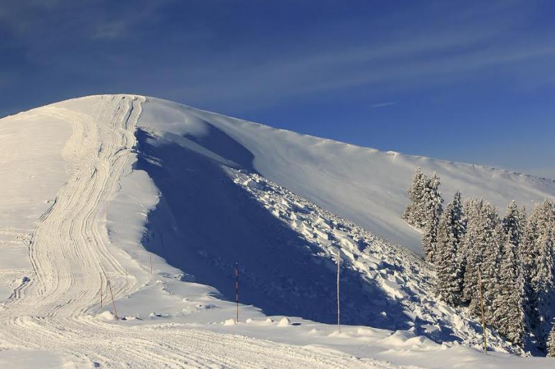
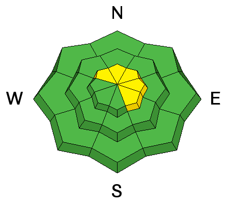
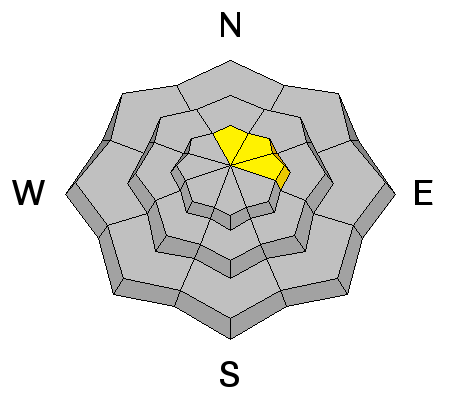
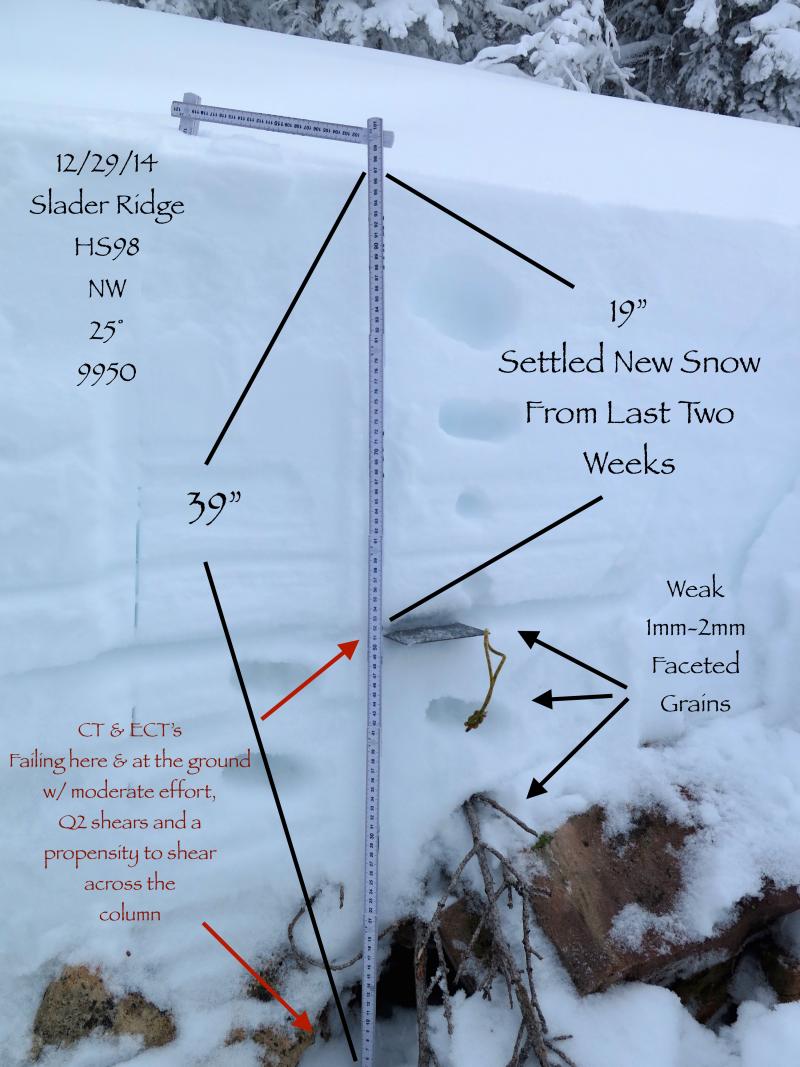
In general you'll find a MODERATE avalanche danger on recently wind loaded slopes at upper elevations and human triggered avalanches are possible. While not widespread and making up a small portion of the terrain available to ride in, slides triggered in steep, rocky, upper elevation terrain, have the potential to break to the ground, especially on slopes facing North, Northeast, and East.

A LOW avalanche danger exists on low and mid elevation slopes facing the south half of the compass and terrain that had no pre-existing snow prior to the big Christmas storm cycle.
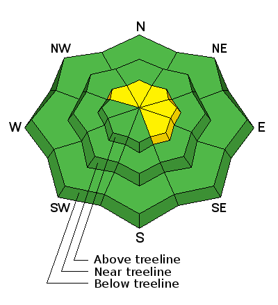
Low
Moderate
Considerable
High
Extreme
Learn how to read the forecast here
Special Announcements

Mountain users:pls keep eyes out for missing police officer, 5'9" 160 lb white male, blue Dodge diesel truck w shell http://ow.ly/GJXB3

Finally there's enough snow to start getting our beacon checkers installed. Thanks to our most excellent intern Bo Torrey for helping get the Nobletts unit sunk in the snow Tuesday.

We just released an exciting, new avy safety video designed specifically for snowmobilers - Knowledge is Powder. https://vimeo.com/113677686

NEW THIS YEAR: You can now receive advisories by email for each region in the state. Go here for details.

Weather and Snow

Clouds rolled into the region overnight as a shallow cold front with a few flurries grazes the region. Temperatures are in the mid 20's and west-northwest winds picked up overnight, currently blowing 35-50 mph along the high peaks. Snow surface conditions in the high terrain are wind damaged, but lose a little elevation, get into some wind sheltered terrain, and the snow is cold, deep, and light.

Lots of wind jacked snow in open terrain throughout the range.

Loud powder in wind sheltered terran.... fun riding now, may become our next week layer.

Recent Avalanches

No new avalanche activity since midweek, however...

This slide in Upper Weber Canyon, was triggered from a distance, breaking deep and wide to weak layers of snow near the ground.

Getting slammed into a stand of natures baseball bats by a fast moving slide would be an immediate buzz-kill, instantly ruining your day, quite possibly ending your season.

Ad
Avalanche Problem #1
Persistent Weak Layer
Type
Location
Likelihood
Size
Description

Today's most obvious avalanche dragon are fresh wind drifts. Winds switched to the west and northwest overnight, and I suspect they'll be a fresh wind drift or two sensitive to the additional weight of a rider. Mostly manageable in size and depth, and breaking at or below your skis, board, or sled, these are easy to detect by their fat, rounded appearance.

Avalanche Problem #2
New Snow
Type
Location
Likelihood
Size
Description

The snowpack appears to be adjusting to the big pre-Christmas storm and I think it's comfortable in it's own skin until the next big storm. While the chances of triggering an avalanche that breaks to deeper buried weak layers in the snowpack are becoming less likely overtime, the consequences remain quite dangerous. The way we deal with low probability/high consequence situations in the mountains is to simply avoid them. Most savvy folks I know are climbing big terrain they know already avalanched to the ground earlier in the season or shredding steeper terrain facing the south half of the compass where the surface snow is still cold and light and the avalanche danger more predictable. Here's a great video illustrating the kind of avalanche dragon we're dealing with.

JG's snowpit tests show the snowpack is starting to heal.

Additional Information

A shallow cold front gives us cloudy skies, a few flurries, and temperatures not varying much from where we are at this morning... hovering in the mid teens. West and northwest winds, blowing 30-40 mph will be annoying along the ridges. Hit or miss snow showers for the next few days, before high pressure takes hold midweek with clear skies and warming temperatures.

General Announcements

Remember your information can save lives. If you see anything we should know about, please participate in the creation of our own community avalanche advisory by submitting snow and avalanche conditions. You can call me directly at 801-231-2170, email [email protected], or email by clicking HERE

This is a great time of year to schedule a free avalanche awareness presentation for your group or club. You can contact me at 801-231-2170 or email [email protected]

Donate to your favorite non-profit –The Utah Avalanche Center. The UAC depends on contributions from users like you to support our work.

Benefit the Utah Avalanche Center when you buy or sell on ebay - set the Utah Avalanche Center as a favorite non-profit in your ebay account here and click on ebay gives when you buy or sell. You can choose to have your seller fees donated to the UAC, which doesn't cost you a penny.

Utah Avalanche Center mobile app - Get your advisory on your iPhone along with great navigation and rescue tools.

The information in this advisory is from the US Forest Service which is solely responsible for its content. This advisory describes general avalanche conditions and local variations always occur.

I will update this advisory by 7:00 AM Sunday Jan. 4, 2015.