Join us for the 17th Annual Professional Snow and Avalanche Workshop (PROSAW) on November 4 - Purchase tickets here!

Forecast for the Logan Area Mountains

Toby Weed
Issued by Toby Weed on
Friday morning, December 26, 2014

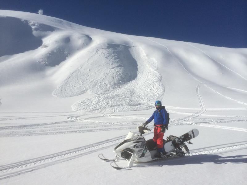
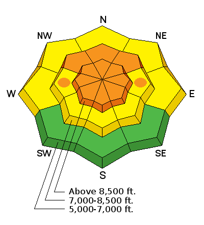
There's a CONSIDERABLE (level 3) avalanche danger, and dangerous avalanche conditions exist on drifted upper elevation slopes. Triggered wind slab and persistent slab avalanches are probable in drifted terrain steeper than about 30 degrees. In some areas, dangerous avalanches might be remote triggered from a distance, or worse, from below.

  • Careful snowpack evaluation, cautious route finding, and conservative decision-making will be essential for safe backcountry travel.
  • Avoid and stay out from underneath drifted upper elevation slopes steeper than about 30 degrees.

Low
Moderate
Considerable
High
Extreme
Learn how to read the forecast here
Special Announcements

We will offer an Avalanche Awareness Class, for beginners and as a refresher for those with some training, including a Field Day in the backcountry. Class begins on January 8 (evening) and all day Saturday January 10. Call Paige at 435-757-2794 for more information.

Weather and Snow

The Tony Grove Snotel reports 8 inches of new containing 0.7" of water in the last 24 hours. There's 64 inches of total snow at the 8400' site containing 136% of average water for the date, and its 20 degrees this morning. The UDOT Hwy 89 Logan Summit weather station is reading 9 degrees and light up canyon winds currently. Should be a very nice powder day indeed, but dangerous avalanche conditions persist on many tempting steep slopes in the backcountry. There is plenty of great untracked lower angled terrain and cold-smoke meadows to play around in today, while we let the snow stability gradually increase before hitting the steeper hills.


Recent Avalanches
  • A fairly widespread natural avalanche cycle occurred at upper elevations in the Logan Zone with the moist Solstice Storm.
  • A rider triggered a good sized persistent slab avalanche Tuesday in the Rodeo Grounds on the east side of Logan Peak. Looks like he escaped the 2 to 3 foot deep by around 200' wide avalanche, which failed on weak snow that was on the surface during the December dry spell.
  • A backcountry skier, the third to descend, triggered, was caught, carried. completely buried, seriously injured, and rescued by his experienced party in the mountains above Salt Lake City on Christmas Eve... Accident Report

Visit our Backcountry Observations Page for more information.....

A sled triggered avalanche in the Rodeo Grounds on Tuesday, 12-23-2014


Ad
Avalanche Problem #1
Persistent Weak Layer
Type
Location
Likelihood
Size
Description

Strong south winds Christmas Eve drifted significant snow in exposed terrain, creating stiff wind slabs on the lee sides of the major ridges and in and around terrain features like gullies and cliff bands. These drifts will be now hidden by a foot or so of fresh snow and softer drifts. A smaller avalanche overrunning a slope with poor snow structure could cause a larger more destructive avalanche. As usual, its best to avoid steep drifted terrain.

Avalanche Problem #2
New Snow
Type
Location
Likelihood
Size
Description

During the Solstice Storm, heavy wind-blown snow overloaded a weak layer consisting of faceted snow and surface hoar that was on the snow surface before the storm arrived. The added weight of the Christmas storm may be enough to overload slopes or bring then back into a volatile balanced state. Triggered avalanches are likely in some terrain steeper than about 30 degrees, and you might remote trigger avalanches from a distance or below. The danger will be most pronounced at upper elevations, on drifted slopes facing the northern half of the compass. Audible collapsing or whoompfing noises indicate dangerous persistent slab avalanche potential in nearby avalanche terrain.

Additional Information

It'll be mostly cloudy and cold in the mountains today, with diminishing light northwest winds, a chance of some snow showers, and temperatures in the single digits. Wind chills will be in the negative 10 degree range, so dress accordingly. It'll be cold and cloudy tonight with temperatures around 2 degrees and sub-zero wind chills. We'll see a bit of sunshine tomorrow morning before winds shift from the southwest and clouds begin moving in in advance of the next round of Pacific storminess moves in Saturday night. We are likely to see decent accumulations in the mountains on Sunday.

Check out our one-stop weather page........HERE

General Announcements

You can now receive advisories by email for each region in the state including Logan. Go here for details.

Get your advisory on your iPhone along with great navigation and rescue tools....... Utah Avalanche Center mobile app

Please submit snow and avalanche observations from your ventures in the backcountry HERE. You can call us at 801-524-5304 or email HERE, or include #utavy in your Instagram or Tweet us @UAClogan. To report avalanche activity in the Logan Area or to contact the local avalanche forecaster call me, Toby, at 435-757-7578.

I'll regularly update this advisory on Monday, Wednesday, Friday, and Saturday mornings by about 7:30. This advisory is produced by the U.S.D.A. Forest Service, which is solely responsible for its content. It describes only general avalanche conditions and local variations always exist.