Forecast for the Logan Area Mountains

Sunday morning, November 30, 2014
There's a LOW (level 1) danger and the snow is stable on most slopes in the Logan Zone. Exceptions, heightened avalanche conditions, and a MODERATE or level 2 danger exist on isolated drifted slopes at upper elevation. Evaluate the snow and terrain carefully, continue to use safe travel protocols, and practice regularly with your rescue equipment.

Special Announcements
We look forward to seeing you at our annual fundraiser party at the Italian Place in Logan on Wednesday evening, December 3... We very much need and value your support.
Weather and Snow
With maybe an inch or so of new snow this morning at the 8400' Tony Grove Snotel. It's 26 degrees and there's 34 inches of total snow containing 150% of average water for the date. The 9700' CSI Logan Peak weather station is recording westerly winds averaging in the mid to upper teens. We're seeing fairly good stability locally. Even an inch or two will help the crusty riding conditions...
Be sure your rescue gear is functioning by practicing with it, and force your partners to join in. It is they who will be your best bet for survival if you get caught in an avalanche. The Tony Grove road is not maintained for wheeled travel in the winter!
Recent Avalanches
No avalanches were recently reported in the Logan Zone, but it's still active and dangerous in the Central Wasatch Range.
Visit our Backcountry Observations Page for details
Persistent Weak Layer


Description
Triggered wind slab avalanches are possible in isolated exposed upper elevation terrain. Very steep slopes on the highest peaks are suspect. Avoid recent deposits of drifted snow on the lee side of major ridges and areas where snow has been deposited into gullies or below cliff bands by the recent strong winds. Fresh accumulations will be quickly drifted by westerly winds today, and more than expected snowfall will create larger fresh wind slabs and heightened conditions.
Additional Information
Snow is likely but accumulations look light, and we'd be lucky to see 1 to 3 inches of accumulation today and again tonight. Snow showers should continue on and off through Monday. Another round of snow will develop late Tuesday and Wednesday.
Check out our one-stop weather page........HERE
USU Wx Cam view of clouds yesterday,(11-28-2014)
General Announcements
Don't forget our annual fundraiser party at the Italian Place in Logan on Wednesday evening, December 3...
Backcountry 101 Avalanche Class coming up! Register now for our first on-snow class of the season. Thursday evening December 11 and all day Saturday December 13. The season is upon us and the time is now to learn how to stay safe in the backcountry. http://utahavalanchecenter.org/classes/backcountry-101-4
NEW THIS YEAR: You can now receive advisories by email for each region in the state. Go here for details.
Utah Avalanche Center mobile app - Get your advisory on your iPhone along with great navigation and rescue tools. Follow us at UAClogan on Twitter
Remember your information can save lives. If you see anything we should know about, please participate in the creation of our own community avalanche advisory by submitting snow and avalanche conditions. You can also call us at 801-524-5304 or 800-662-4140, email by clicking HERE, or include #utavy in your Instagram.
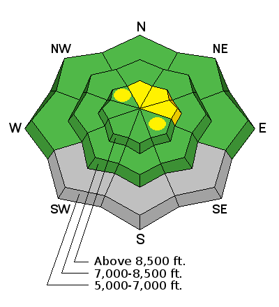
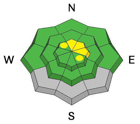
To report avalanche activity in the Logan Area or to contact the local avalanche forecaster call me, Toby at 435-757-7578. I'll regularly update this advisory on Monday, Wednesday, Friday, and Saturday mornings by about 7:30....
This advisory is produced by the U.S.D.A. Forest Service, which is solely responsible for its content. It describes only general avalanche conditions and local variations always exist.