Forecast for the Moab Area Mountains

Eric Trenbeath
Issued by Eric Trenbeath for
Sunday, January 12, 2014

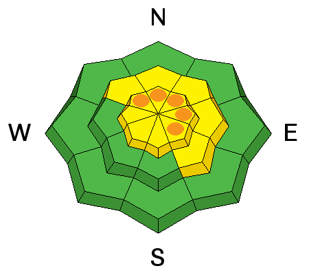
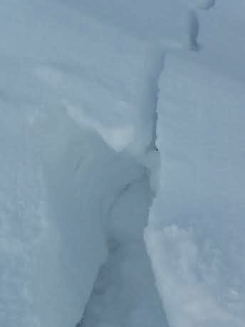
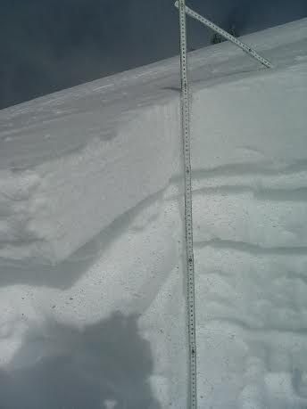
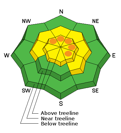
Pockets of CONSIDERABLE danger, where human triggered avalanches are likely, exist above tree line on slopes steeper than 35 degrees where there are recent deposits of wind drifted slow. This danger is most prevalent on slopes with N-E-SE aspects, but be alert to cross loading on west facing slopes as well.

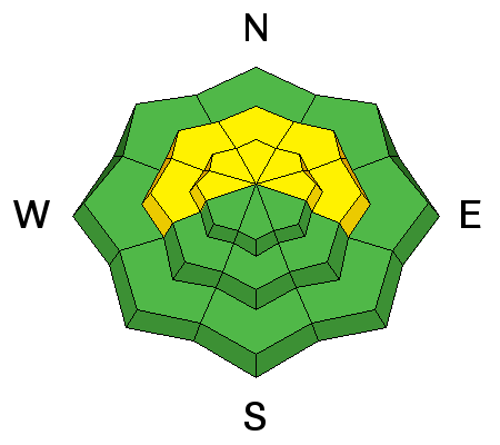
There is a MODERATE avalanche danger in wind affected terrain below tree line in areas of wind drifted snow .

The danger is generally LOW on sheltered, lower elevation terrain.

Low
Moderate
Considerable
High
Extreme
Learn how to read the forecast here
Weather and Snow

La Sal Mountains

We'll always take it, but I'm afraid the last round of snow did little to improve overall conditions except on very sheltered, mid and lower elevation terrain. It came in with so much wind that exposed areas were left scoured, and even semi sheltered, northerly aspects developed wind crusts.Sheltered south and west aspects had decent dust on crust conditions, but the strong sun yesterday put a stop to that. In addition, the light density snow wasn't enough to fill in old tracks in the sheltered wooded areas. After a brief respite yesterday, winds have been on the increase since about 10:00 last night with averages near 30 mph and gusts up to 50 from the WSW. Today winds will remain strong with a shift to the NW. Expect snow showers and blowing snow with 2"-4" possible.

Abajo Mountains

Winds are howling on Abajo Peak, averaging 25 mph from the WSW with gusts near 60. Camp Jackson has reported no new snow from the last storm, and low snow conditions prevail. Snow depths range from about 18"-24" of snow about 10,000' on shady aspects. Bare ground is exposed on south facing slopes, and even east facing slopes with a slight southerly component are showing areas of exposed ground. The mountains could see 1"-2" of new snow today, but strong winds from the WNW will be the featured player.

Ad
Avalanche Problem #1
Persistent Weak Layer
Type
Location
Likelihood
Size
Description

The wind slabs I observed on Friday lost a lot of their sensitivity yesterday, but with another round of strong winds and blowing snow on tap, expect a repeat performance today. Never underestimate the power of the wind, especially when there is a few inches of snow involved. Today you will need to be on the lookout for signs of instability such as cracking or collapsing, and avoid areas of recently deposited, wind drifted snow. Due to shifting wind directions, be alert on all aspects at upper elevations, but especially those that have an easterly component.

Cracking up to a foot deep on an east facing ridge crest indicated recently deposited wind slabs on Friday. Look for similar conditions today.

Wind slab observed on Friday, over riding a weak, crust/facet combination.

Avalanche Problem #2
New Snow
Type
Location
Likelihood
Size
Description

New wind slabs have re-activated the potential for triggering a deeper, persistent slab. The snow pack remains extremely weak with a variety of buried faceted layers, facet crust combinations, and depth hoar. Compression tests displayed reactive weak layers throughout the pack.

Additional Information

Snow and blowing snow will greet mountain travelers today with 2"-4" of new snow possible. Ridge top winds will average 25 mph with gusts in the 40's out of the WNW. Temperatures have been on the decrease all night and we are nearly at are expected high today of 19 degrees at 10,000'.Things will finish up tonight with clearing skies and low temperatures around 12 degrees. Monday looks to be sunny and warmer as high pressure builds again for the week.

General Announcements

OBSERVATIONS: Thanks to Evan, Matt, and Ryan for your recent observations. You can read OBSERVATIONS HERE. If you are out and about in the mountains, I'd love to know what you are seeing so please SUBMIT OBSERVATIONS

LUNA GROOMING INFORMATION: Groomers were out again on Saturday.

ROAD CONDITIONS: The road is clear.

UAC MOBILE APP: Get your advisory on your iphone with this app