Forecast for the Uintas Area Mountains

Craig Gordon
Issued by Craig Gordon for
Wednesday, December 19, 2012

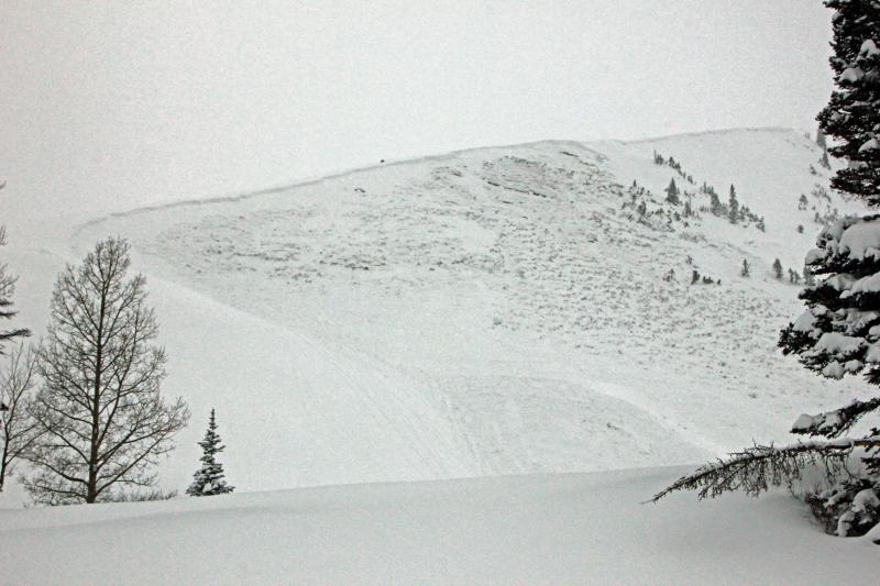
Terrain to avoid- Upper elevation leeward slopes facing the north half of the compass The avalanche danger is CONSIDERABLE on steep wind loaded slopes, especially those facing East, North, and Northeast. Dangerous and possibly unsurvivable human triggered avalanches are probable.

A MODERATE avalanche danger exists in mid elevation terrain and human triggered avalanches are possible.

If you're looking for LOW avalanche danger head to low elevation, wind sheltered sheltered terrain.

Low
Moderate
Considerable
High
Extreme
Learn how to read the forecast here
Weather and Snow

As yesterdays storm system exits the region, it leaves in it's wake over 2' of ultra-light, in your face powder, and single digit temperatures. Northwest winds are blowing 15-25 mph along the ridges giving us wind chill values near -25 degrees... man it's cold out! It was a bottomless, wallowfest yesterday, but I think the snow has settled a bit overnight and getting around should be a little more user-friendly.

Recent observations can be found here.

Wondering why last winter was so crazy? Click here to watch the 2011-12 Utah Winter Review... an excellent recap of last years conditions.

Recent Avalanches

Trent and I got a huge, booming collapse yesterday and decided to tone down our objectives and stick with low angle terrain.

Currant Creek Peak avalanched to the ground sometime late Monday night or early Tuesday morning. The slide was 4'-7' deep x 1000' wide. Arrows indicate the connected crown which stretches low on the slope. Here's a short video explaining what we found.

Ad
Avalanche Problem #1
Persistent Weak Layer
Type
Location
Likelihood
Size
Description

The snowpack is slowly adjusting to all the added weight of the recent storm and we're at a tenuous crossroads with snow stability. As the snow gains strength, today you'll be able to ride plenty of slopes and not trigger any avalanches. As a matter of fact, the snow will feel strong and stable under our skis, board, or sled. Unfortunately, it's these exact type of conditions that allow us to get into steeper, more avalanche prone terrain and get well out onto the slope before triggering a slide. Once triggered, today's avalanches have the potential to break wide and deep, taking out the entire seasons snowpack, producing a very dangerous and possibly unsurvivable slide. It doesn't mean you can't ride. It does mean that you need to match your terrain choices with the avalanche danger and think about the consequences. You can have a blast carving turns in meadows and low angle slopes with no steep terrain above or connected to the slope you're riding.

.

This large slide in Upper Weber Canyon was remotely triggered on a heavily wind loaded ENE aspect. 3'-5' deep and 400' wide, the avalanche broke to ground taking out the entire seasons snowpack.

Avalanche Problem #2
Persistent Weak Layer
Type
Location
Likelihood
Size
Description

Once initiated, today's shallow slabs can quickly get out of hand, breaking into deeper buried weak layers as they crash down onto the slope below and they'll be packing a punch.

Additional Information

Clearing skies with daytime highs near 10 degrees. Northwest winds blow 15-25 mph along the ridges with a few gusts to 40 mph along the high peaks. Overnight lows bottom out to near -10 degrees. A warming trend develops tomorrow and we should see partly cloudy skies through Saturday. A weak storm slides into the region Sunday, but it doesn't look like a big snow producer. Not much agreement with the computer models for next week.

General Announcements

Remember your information can save lives. If you see anything we should know about, please participate in the creation of our own community avalanche advisory by submitting snow and avalanche conditions. You can call me directly at 801-231-2170, email [email protected], or email by clicking HERE

This is a great time of year to schedule a free avalanche awareness presentation for your group or club. You can contact me at 801-231-2170 or email [email protected]

Donate to your favorite non-profit –The Friends of the Utah Avalanche Center. The UAC depends on contributions from users like you to support our work.

The information in this advisory is from the US Forest Service which is solely responsible for its content. This advisory describes general avalanche conditions and local variations always occur.

The information in this advisory expires 24 hours after the date and time posted, but will be updated by 7:00 AM Saturday December 22nd.