Forecast for the Uintas Area Mountains

Craig Gordon
Issued by Craig Gordon for
Friday, April 5, 2024
Well, we need more wind... said no one ever, but it is aiding to temper our wet snow avy issues and it'll help usher in a fresh coat of white paint-
This morning, the avalanche danger is generally LOW and human triggered avalanches are UNLIKELY.
If today's storm over-produces, the avy danger rises to MODERATE, especially in the wind zone, above treeline. Shallow, fresh drifts materialize and human triggered avalanches become POSSIBLE on steep, leeward, wind drifted slopes facing the north half of the compass.
Low
Moderate
Considerable
High
Extreme
Learn how to read the forecast here
Weather and Snow
Nowcast- Winds blowing from the south aren't just obnoxiously cranking in the 40's and 50's, they're screaming into the 60's and 70's near the high peaks. Even with clear skies overhead, temperatures are rather balmy, hovering right around freezing. The snow surface offers a mixed bag and it'll be rugged out there this morning. With a good shot of snow materializing in the next 24 hours, I think I'd opt for a day of chores and get after it tomorrow.
Forecast- Look for increasing clouds with a little wiggle of storminess skating through around midday. Nothing to get too excited about... perhaps just a couple inches to help cushion the old snow surface. Winds continue blowing from the south, tapering into in the 30's and 40's, increasing again midday into the 60's. We've probably reached our high temperature for the day and the mercury begins diving into the teens overnight.
Futurecast- Storminess finally gels together for Saturday and we should see a foot of snow stack up during the day along with colder temperatures which barely crack into the mid 20's. The storm slides to the east on Sunday, though we may see lingering snow showers throughout the day.
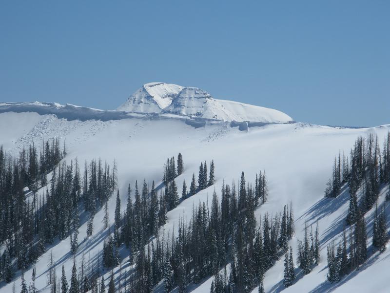
Guardians of the steep... Bald Mountain and Reids Peak keep a watchful eye on Upper Moffit Basin from afar.
The Uintas are fat and white. In fact, last weeks stormy weather stacked up nearly three feet of snow with over 4" of water at the Trial Lake SNOTEL
Recent Avalanches
No significant avy activity for a few days. Below are a few examples of recent damp snow and wind drifted slides from earlier in the week-
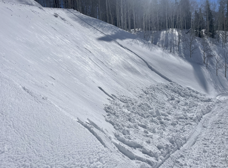
Wednesday's strong sunshine brought the weekend storm snow to life, resulting in shallow, damp slides, like this one above a road cut late in the afternoon.
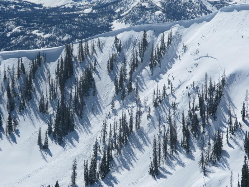
On Wednesday, Trevor spotted this natural slide in Upper Moffit Basin that occurred as a result of Sunday's strong wind and periods of intense snowfall.

For all Uinta observations and archived avalanche activity click HERE.
Ad
Avalanche Problem #1
Wind Drifted Snow
Type
Location
Likelihood
Size
Description
As today's storm materializes, winds will have a little new snow to work with, and that combo whips up a batch of fresh drifts on the leeward side of upper elevation ridges. Not a big deal and certainly nothing to get alarmed over, but it's best to avoid wind drifted slopes that appear fat or rounded and sound hollow like a drum, 'cause even a shallow drift can catch you by surprise, delivering an unexpected ride in sustained, steep terrain.
Additional Information
The Uinta weather station network was upgraded this summer and all that real-time info is found HERE. Simply click on "western Uinta" tab and then "weather stations" tab.

We are always looking for snow and avalanche observations or just general riding conditions. So... if you see something, say something. You can reach me directly at [email protected] or 801-231-2170.
Also, if you're looking for more avy education opportunities for yourself, your crew, or your club please don't hesitate to reach out to me and we'll find a presentation, class, or clinic for ya!
General Announcements

Issued at 0330 on Friday, April 5th this forecast will be updated by 0700 Saturday, April 6th, 2024.
This forecast is from the U.S.D.A. Forest Service, which is solely responsible for its content. This forecast describes general avalanche conditions and local variations always occur.