Forecast for the Uintas Area Mountains

Craig Gordon
Issued by Craig Gordon for
Saturday, April 13, 2024
The danger rose suggests generally LOW avalanche danger and yes this is the time of year to get after it... but remember... LOW avy danger ain't NO avy danger-
Even though human triggered avalanches are UNLIKELY, as we stretch our wings and consider bigger objectives, let's keep in mind that even a small avalanche can ruin our day if we get knocked off our feet in steep, technical, committing terrain.
Low
Moderate
Considerable
High
Extreme
Learn how to read the forecast here
Special Announcements
Tomorrow, Sunday, April 14th will be the last of our regularly scheduled daily forecasts
Gear up for next season or snag deals to close out this season while supporting the UAC’s efforts. Your participation directly funds the state's avalanche forecasting, awareness, and education programs. Check out the auction found here!
Weather and Snow
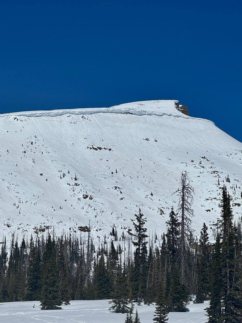
Nowcast- Dang... it's downright balmy this morning as a band of high, thin, clouds drifted through the area last night, putting a lid on overnight temperatures which barely dipped into the low and mid 30's. Meanwhile, winds blowing from the south decreased slightly at the turn of the new day, yet are still obnoxious, blowing in the 20's and 30's near the high peaks. The snow is taking a hit and the window for good riding and turning opportunities is shrinking. Mid and lower elevation south facing slopes offer a crop o' corn, ready for harvesting first thing this morning. If you're looking for shallow pow it's a rare commodity, but I think a few swaths still exist on high north facing slopes in the alpine.... getting there is gonna be on the rugged side.
Forecast- Look for mostly sunny skies with temperatures climbing into the 50's. Southerly winds blow in the 30's along the ridges. Overnight lows dip into the low 30's.
Futurecast- Storminess is on tap for Sunday, bringing gradually cooler temperatures and a couple inches of snow for Monday. Unsettled weather is on tap to kick off the work week.
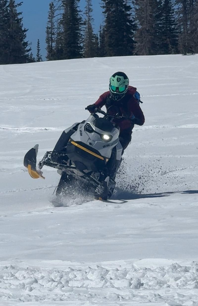
Johanna Kelly is a rippin' sledder, an avy forecaster for Snowbird, but more important... an overall amazing person. Here, she displays her afternoon sled prowess near Mirror Lake Highway yesterday afternoon. JK and her partner in life and UAC forecaster extraordinaire, Dave Kelly, shared a field day near Bald Mountain and have a great trip report found HERE.
A celebrity sighting!!! Ted Scrogggin was in the Gold Hill zone on Friday and says... "There are a few slivers of cold dry snow on north facing slopes, but any subtle change in aspect and the snow quickly turns to either damp or a melt freeze crust."
Recent Avalanches
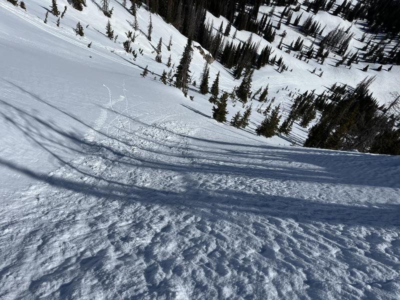
Most likely triggered from damp snow dribbling down from above, Dave and Johanna spotted this recent wet slab in the steep, rocky area of Haystack
No other significant avalanches have been reported over the last few days. Archived avalanche activity and trip reports are listed HERE.
Ad
Avalanche Problem #1
Normal Caution
Type
Location
Likelihood
Size
Description
The snowpack is deep, it's homogeneous, it's happy in its own skin, and it's generally bomb dot com. Yeah... avy danger is straight-forward and there's plenty of room to roam on a go-anywhere base.
A couple things to consider as we stretch our wings-
Cornices, like these overhanging monsters on Bald Mountain, are ginormous and may break further back than you might expect or even naturally. As the mercury begins its uphill migration this week, we'll definitely wanna give these huge boxcar pieces of snow a wide berth.
If you're feeling like an ant under a magnifying glass... so is the snowpack. As the surface starts to become damp and mushy, you'll wanna think about moving to a cooler aspect. You know you've overstayed your welcome when the snow turns to wet glop or it's becoming unsupportable.
Additional Information
The Uinta weather station network was upgraded this summer and all that real-time info is found HERE. Simply click on "western Uinta" tab and then "weather stations" tab.

We are always looking for snow and avalanche observations or just general riding conditions. So... if you see something, say something. You can reach me directly at [email protected] or 801-231-2170.
Also, if you're looking for more avy education opportunities for yourself, your crew, or your club please don't hesitate to reach out to me and we'll find a presentation, class, or clinic for ya!
General Announcements

Issued at 0300 on Saturday, April 13th this forecast will be updated by 0700 Sunday, April 14th, 2024.
This forecast is from the U.S.D.A. Forest Service, which is solely responsible for its content. This forecast describes general avalanche conditions and local variations always occur.