Forecast for the Uintas Area Mountains

Craig Gordon
Issued by Craig Gordon for
Tuesday, March 8, 2022
HEADS UP -
Our structurally challenged weak layers teeter on the edge and with more storminess on the way, avalanche danger is gonna get real.
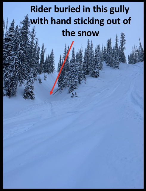
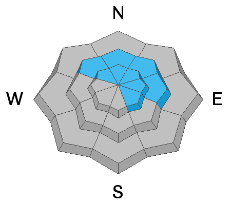
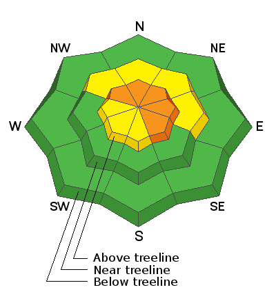
Most pronounced near and above treeline, a CONSIDERABLE avalanche danger is found where recent wind drifts rest on top of a pre-existing, weak layer of sugary snow. Human triggered slides breaking deeper and wider than you might expect are LIKELY, especially on steep, upper elevation slopes facing the north half of the compass and particularly those with an easterly component to their aspect.
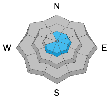
Mid elevation terrain at treeline offers MODERATE avalanche danger and human triggered avalanches are POSSIBLE on steep, shady slopes.
Looking for LOW avalanche danger? Well then, you've got plenty of options. Simply lose some elevation, swing over to the south half of the compass or tag some lower elevation trailhead shots where human triggered avalanches are UNLIKELY.

Low
Moderate
Considerable
High
Extreme
Learn how to read the forecast here
Avalanche Watch
* WHAT...A POWERFUL WINTER STORM COULD CREATE VERY DANGEROUS AVALANCHE CONDITIONS IN THE BACKCOUNTRY. THE AVALANCHE DANGER FOR THE WATCH AREA WILL LIKELY RISE TO HIGH.
* WHERE...FOR THE MOUNTAINS OF NORTHERN UTAH, INCLUDING THE WASATCH RANGE, WESTERN UINTAS AND THE BEAR RIVER RANGE.
* WHEN...IN EFFECT FROM 6 AM MST THIS MORNING TO 6 AM MST WEDNESDAY.
* IMPACTS...HEAVY SNOWFALL AND BLOWING SNOW WILL CREATE WIDESPREAD AREAS OF UNSTABLE SNOW. HUMAN TRIGGERED AND NATURAL AVALANCHES WILL BECOME LIKELY. PEOPLE SHOULD AVOID TRAVEL IN AVALANCHE TERRAIN, AND STAY OFF AND OUT FROM UNDER SLOPES STEEPER THAN 30 DEGREES.
Weather and Snow
NOWCAST-
High clouds drifted into the region overnight, delivering a trace of snow and continued cold temperatures which currently register in the single digits and low teens. Along the ridges, west and northwest winds bumped into the 20's late last night and continue in that spirit with a few gusts in the 30's near the high peaks. The weekend storm delivered 9" of snow and riding conditions are outstanding, especially on low angle terrain where you won't feel so much of the old snow surface underfoot.
FORECAST-
A cold storm is on the doorstep and should arrive later this morning. Look for increasing clouds with snow developing right around suppertime. Temperatures barely climb into the low 20's while west and northwest winds become a nuisance, blowing in the 30's and 40's as the day progresses. The first wave of storminess stacks up 3" of snow by sunset.
FUTURECAST-
The storm kicks into gear late tonight and really gets going early Wednesday when cold, moist air brings periods of heavy snow. A foot of snow by the time your alarm goes off is a good bet.
Trip reports and current state of the snowpack observations are found HERE.

Looking for real-time temps, snow, or wind?
Click HERE and then on the "western Uinta" tab for western Uinta specific, weather station network.
Recent Avalanches
We're still sifting through details, but here's what we know about a close call late Monday afternoon near Humpy Peak-
A group of sledders is riding in the Humpy drainage when one snowmobiler triggers a small piece of snow on a steep, north facing slope which catches, carries, and buries him in a terrain trap (small gully). The rider tries to deploy his airbag, though is unable to successfully engage and he's buried with a hand sticking out of the snow. The sledder briefly loses consciousness, but everyone in the group is wearing avalanche rescue gear and they quickly locate the buried rider and dig him out. The group is pretty rattled, but after taking some time to regroup in the Whitney Basin warming hut, they ride back to their rigs and return home safely.. Whew... close call!

Your input is vital and we're interested in what you're seeing. Please contribute to this great community resource and go here to fill out an observation.
Ad
Avalanche Problem #1
Persistent Weak Layer
Type
Location
Likelihood
Size
Description
The image above illustrates the avalanche dragon we're dealing with. Triggered from a distance, this slide was initiated on a relatively low angle 32 (+ or -) degree, north facing slope, in Upper Weber Canyon yesterday afternoon.
Make no mistake, this is an unusual snowpack setup for us and we need to pump the brakes and re-evaluate the type of terrain we generally get after in the spring-
Here's what's going on... weak layers of sugary snow developed on the surface of the snowpack during the January/February dryspell. Yes, the livin' was easy and it was great recycled powder or what we call near surface faceted snow (NSF).
Now here's the problem... NSF is a weak layer that's now buried and preserved in our snowpack and it's coming out of it's dormancy and back to life. In fact, we've hardly added any additional weight to this fragile weak layer and the wheels are already coming off. Let's face it, we're not going to outsmart this avalanche dragon, so avoidance is the big ticket item. Simply avoid where it lives and that means steering clear of steep, mid and upper elevation terrain which faces the north half of the compass.
Avalanche Problem #2
Wind Drifted Snow
Type
Location
Likelihood
Size
Description
Above is a 24 hour data dump from Windy Peak (10,661') illustrating an uptick in this mornings WNW winds.
Overnight winds have no problem whipping up a fresh round of drifts that'll be reactive to our additional weight today. Here's the curve ball... wind drifted snow stacks up on a variety of old snow surfaces and some are quite hard and slick. Any avalanche triggered on a sustained steep slope may run further and faster than you might expect. Something to consider if you're tagging a big, technical line.
Additional Information
Your observations are important, so please let me know what you're seeing... click HERE and contribute to this amazing community based program
General Announcements
The information in this forecast expires 24 hours after the day and time posted, but will be updated by 07:00 Wednesday, March 9th.
Before it gets too crazy, now is the time to book an avalanche awareness presentation for your group, club, or posse. You can reach me directly at 801-231-2170 or [email protected]
This forecast is from the U.S.D.A. Forest Service, which is solely responsible for its content. This forecast describes general avalanche conditions and local variations always occur.