Forecast for the Uintas Area Mountains

Craig Gordon
Issued by Craig Gordon for
Thursday, March 30, 2023
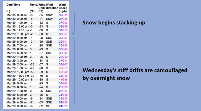
Fresh snow and strong winds deliver a one-two punch-
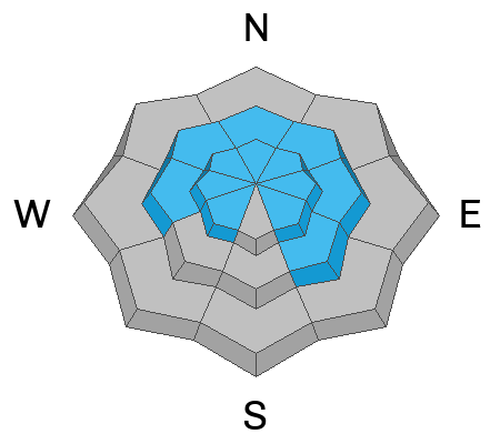
In the wind zone, above treeline, you'll find HIGH avalanche danger. On steep, rocky, upper elevation slopes, both human triggered and natural avalanches are VERY LIKELY. Terrain facing the north half of the compass, especially steep slopes with an easterly component to its aspect have the potential to produce avalanches that'll pack a punch and could easily ruin your day. CONSIDERABLE avalanche danger is found near treeline and human triggered avalanches are LIKELY on steep slopes with recent deposits of wind drifted snow. More predictable MODERATE avalanche danger is found on steep, lower elevation slopes, where storm snow reacts to our additional weight and human triggered avalanches are POSSIBLE.

Low
Moderate
Considerable
High
Extreme
Learn how to read the forecast here
Special Announcements
On Monday, March 27, two snowmobilers were riding in the Oquirrh Mountains. One was caught, carried, and fully buried in a very large avalanche. His partner, friends and family, Utah County Search and Rescue, Utah Department of Public Safety, and LifeFlight participated in the rescue, but he sadly did not survive. The preliminary avalanche report can be found HERE. The entire UAC team expresses our deepest condolences to everyone affected by this tragic avalanche.
Thank you to everyone who donated to our Spring Campaign. We appreciate your support and look forward to creating new tools to help you stay safe in the backcountry.
Also... I am in the process of finalizing a report regarding the March 9th avalanche fatality in the Uinta's. Thank you for your patience... we will publish the final report in coming days.
Weather and Snow
Nowcast- Under mostly cloudy skies, snow began falling late last night, so far delivering 4" of medium density snow. At o'dark thirty, a solid band of moisture marches towards the eastern front as cooler air filters into the region and temperatures dip into the teens and low 20's. Winds... you know we cornered the market on that commodity and continue living up to the gold standard with southerlies blowing in the 50's and 60's for much of Wednesday, though tapering off into the 30's early this morning. Last nights little refresh will go a long way to improve riding and turning conditions, especially on low angle, wind sheltered slopes.
Forecast- Look for decreasing snow showers with a bit of a midday break. Temperatures remain cool, only reaching into the mid 20's. We get a break from the southerly winds as they taper into the 30's near the high peaks.
Futurecast- Another, potentially more robust shot of snow slides into the area overnight, lingering into Friday morning. A break is slated for Saturday.
Trip Reports-
Detailed trip reports and recent obs are found HERE.
Recent Avalanches
No significant recent avalanches to report in the past day or two, but plenty of avy activity to peruse if ya wanna geek out. Click HERE to track this years slide activity throughout the range.
Ad
Avalanche Problem #1
Wind Drifted Snow
Type
Location
Likelihood
Size
Description
Lofty Lake Peak (11,186') is about the best upper elevation wind site around, especially for southerly winds. Please ignore the temps and windchill, they're a bit wonky, instead focus on the wind speed, direction, and duration which illustrate recent wind loading trends in the wind-zone.
With no shortage of fresh snow available to blow around, recent winds have no problem whipping up fresh drifts reactive to our additional weight. Remember... there are several storms worth of wind drifted snow stacked up on leeward slopes in the wind zone and once triggered, todays avalanches are gonna pack a hefty punch. It doesn't mean you shouldn't ride... it does mean that rather than blindly center-punching a big objective with no beta, gather as much information as you can about the snowpack. Tweak small test slopes similar in aspect, elevation, and slope angle to the kinda terrain you plan on riding and see how they're reacting. In addition, have an exit plan in place in case things go sideways and discuss that with your crew before considering big terrain. Remember... you can have a blast on slopes protected by the wind and not even have to pull on the avalanche dragons tail today.

Avalanche Problem #2
New Snow
Type
Location
Likelihood
Size
Description
Today's storm snow falls on a variety of hard, slick surfaces and will easily react to our additional weight at all elevations. If the sun pokes out even for a moment or two, expect the snow to instantly come to life. Remember... even a small new snow slide can take you for an unexpected ride, especially in sustained, steep terrain.
Additional Information
Weather stations-
And... rime events from January's atmospheric rivers severely crippled the Uinta weather station network. I'm working to get it back up and running, but a few stations are found HERE (click weather stations, and then on the Western Uinta tab)
Observations-
Your observations are important, so please let me know what you're seeing... click HERE and contribute to this amazing community-based program
General Announcements
Issued at 03:07 on Thursday March 30th this forecast expires 24 hours after the date and time posted, but will be updated by 07:00 Friday March 31st 2023.
Before it gets too crazy, now is the time to book an avalanche awareness presentation for your group, club, or posse. You can reach Craig directly at 801-231-2170 or [email protected].

This forecast is from the U.S.D.A. Forest Service, which is solely responsible for its content. This forecast describes general avalanche conditions and local variations always occur.