UDOT PLANNED AVALANCHE CLOSURES!!

Forecast for the Uintas Area Mountains

Andrew Nassetta
Issued by Andrew Nassetta on
Monday morning, March 24, 2025
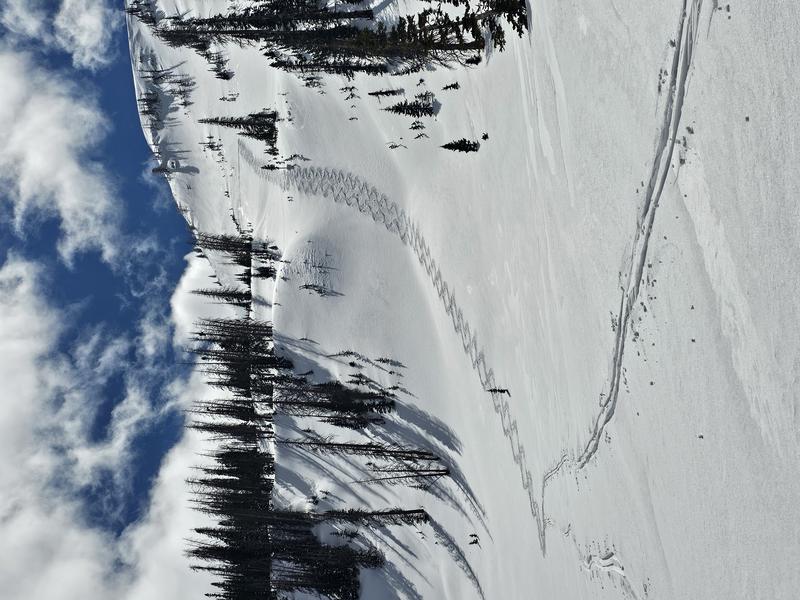
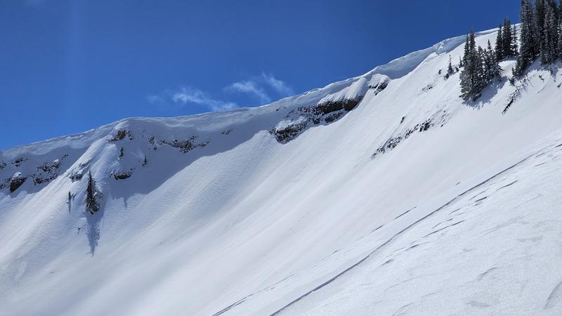
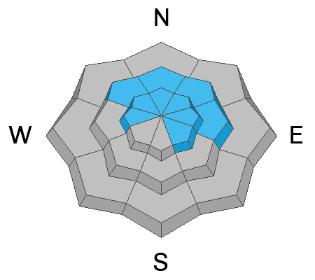
At upper-elevations MODERATE avalanche danger exists for wind-drifted snow on slopes facing northwest through southeast where it’s POSSIBLE to trigger an avalanche up to 2’ deep. All other slopes offer LOW avalanche danger, and although UNLIKELY, in isolated areas you could trigger a slide into faceted snow on mid and upper-elevation northerly slopes.
During the spring and our first few days of significant warming, avoid being on or underneath slopes with large cornices and always watch out for for wet snow avalanches and increased sensitivity of the snowpack at the peak of the days heat.
Low
Moderate
Considerable
High
Extreme
Learn how to read the forecast here
Special Announcements
  • Please join Craig Gordon at Park City Brewing on Wednesday, March 26th at 6pm for a State of the Snowpack presentation. Craig will review the perceived notion of a low tide season and focus on decision making with a Persistent Weak Layer -- Sign-up for free here!
  • Our Spring Campaign is in full swing, and there are two great ways to support forecasting, awareness, and education across Utah: Donate to our Spring Campaign or bid on items in our Spring Auction. Every dollar helps keep the backcountry community on top. Thank you for your support!
Weather and Snow
Nowcast A brief freeze overnight leads to a beautiful spring morning with trailhead temperatures warm at 35℉ as of 0500 while 10,000' temps are already in the mid-20's. Winds work from the northwest and are averaging 20 MPH with a few gusts into the 30's at upper elevations.
Forecast Temperatures rocket into the 40's and 50's today softening slopes at all elevations and turning many of our trailheads into an afternoon mud-bog rally. Northwesterly winds should temper off later this morning and lead to one heck of a beautiful, calm day with clear skies.
Futurecast Like Craig said yesterday, the warm-up continues and we look to hit 60℉ in the sun tomorrow. Expect more of the same till we shake things up later this week and bank for a refresh heading into the weekend.
Travel & Riding Conditions Riding has been full-on spring rippin with a go-anywhere, nothing-but-traction, supportable snowpack that allows you to walk, ride, ski or sled all over the place. Solars have been a mix of supportable, and unsupportable surfaces but a decent freeze and some settlement should help things ride soft and creamy on the sunnies today as things warm-up. Polars continue to hold cold snow in sheltered upper elevations, but it wont last long, get it while the window closes.
Craig and Joey taming a northeast slope at 10,500', as spring finds it's stride, taking a nibble off the edge of bigger slopes and pieces of terrain is a great way to begin "stepping-out" as the pros say.
Recent Avalanches
No new avalanche activity was reported from the backcountry in the past 24hrs. The last significant avalanche breaking into faceted snow was reported over two weeks ago. Check out all the action, info and intel for the Uinta range and beyond, here.
Ad
Avalanche Problem #1
Wind Drifted Snow
Type
Location
Likelihood
Size
Description
West northwest winds picked up in the mid-night and stubborn slabs of wind-drifted snow exist on northwest through southeast slopes. Today's drifts will be specific to high ridgelines and near terrain features like gully walls, cliff-bands, subridges and slope convexities (rollovers). Watch for and avoid stiffer snow that appears smooth, chalky, and rounded, and pay attention when stomping around on it as it may sound hollow, like a drum. Stiffer slabs may allow you to get out on slope and make a few turns or trench a track before triggering it, while fresher, softer drifts will be more sensitive to our additional weight and easier to initiate.
A large cornice that hang's unsupported above a steep, long running avalanche path facing northeast. With day time heating, I want to give these things plenty of room as they are hazardous in their own nature, but could also be the large trigger waiting to pry out some old lingering snow.
Avalanche Problem #2
Persistent Weak Layer
Type
Location
Likelihood
Size
Description
The likelihood of triggering a persistent slab avalanche is decreasing, and most of our weak layers from early November all the way up until March are dormant. Although we are building confidence in the strength of the weak layers and structure of the snowpack there's still a small chance we could trigger a nasty slide. Here are some things to keep in mind that help me steer clear of the lingering weak snow and its avalanche problems:
  • We are not going to see obvious red flags like cracking, or hear big, booming collapses so don't put all your eggs in that basket.
  • If you pull out your probe and find a shallower area of the snowpack (100-175cms) dig around or trench down, you'll see this weak snow.
  • Where this problem exists is such a small and isolated portion of or terrain across the range, there is so much good riding to be had while avoiding the hazard.
  • Big triggers can produce big avalanches -- Watch out for cornice failure or rapid change, anything that could help pry out one of these nasty slides.
Additional Information
General Announcements
We are always looking for snow and avalanche observations or just general riding conditions. In the meantime reach out to us with questions, concerns, or if you see anything in your travels! Contact us directly through the info below:
This forecast is from the U.S.D.A. Forest Service, which is solely responsible for its content. This forecast describes general avalanche conditions and local variations always occur. This forecast was issued on Monday, March 24th at 05:30 AM and expires 24 hours after it was issued.