Forecast for the Uintas Area Mountains

Andrew Nassetta
Issued by Andrew Nassetta on
Tuesday morning, March 25, 2025
At upper-elevations around the compass MODERATE avalanche danger exists for wind-drifted snow where it’s POSSIBLE for us to trigger an avalanche 6-12". Additionally, in isolated areas on the north half of the compass at mid and upper-elevations there is a LOW danger for triggering a slide into old faceted snow. Although LOW danger means UNLIKELY, for myself it means there is still a chance of triggering a nasty slide.
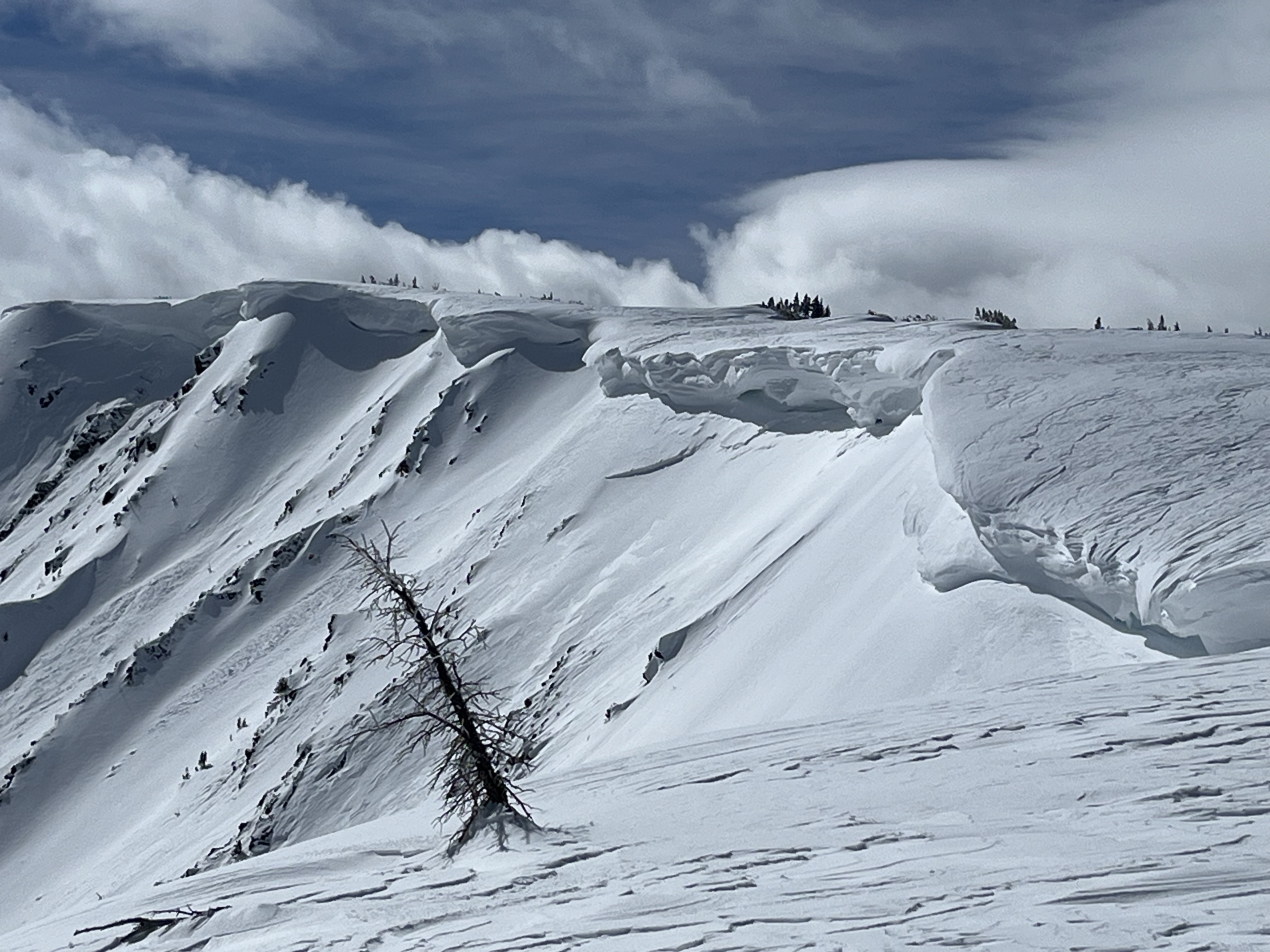
Another warm day is on tap, so remember to avoid being on or underneath slopes with large cornices and always watch out for for wet snow avalanches and increased sensitivity of the snowpack at the peak of the days heat.
Low
Moderate
Considerable
High
Extreme
Learn how to read the forecast here
Special Announcements
  • Please join Craig Gordon at Park City Brewing on Wednesday, March 26th at 6pm for a State of the Snowpack presentation. Craig will review the perceived notion of a low tide season and focus on decision making with a Persistent Weak Layer -- Sign-up for free here!
  • The final report for the Hoyt Peak avalanche accident on March 7th has been published and is available, here.
  • Our Spring Campaign is in full swing, and there are two great ways to support forecasting, awareness, and education across Utah: Donate to our Spring Campaign or bid on items in our Spring Auction. Every dollar helps keep the backcountry community on top. Thank you for your support!
Weather and Snow
Nowcast Temperatures dipped below freezing last night at upper elevations while holding much warmer at the trailheads and in the valley. As of 0500 AM, temperatures at 10k' are hovering in the high 20's accompanied by light northerly winds gusting into the 20's, while low elevations tickled 32℉.
Forecast A real steamer out there today with temperatures spiking into the 40's and 50's again and things could feel even warmer than yesterday, very spring-esque. Variable winds are expected, but look to back throughout the day and will be light around 15 MPH gusting into the 20's along the high peaks bringing in colder temperatures into tonight.
Futurecast A refreeze is on tap for this evening and we are staying hopeful for a little refresh for the weekend. Stay tuned.
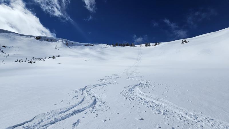
Travel & Riding Conditions Riding has been full-on spring ripping with a go-anywhere, nothing-but-traction, supportable snowpack that allows you to move all over. Solars have been a mix of supportable, and unsupportable surfaces but a decent freeze and some settlement should help things ride soft and creamy on the sunnies today as things warm-up. Polars continue to hold cold snow in sheltered upper elevations, but the last of it will be up for grabs today!
Craig and Joey taming a northeast slope at 10,500'. Taking a nibble off the edge of bigger slopes and pieces of terrain is a great way to begin "stepping-out" as the pros say instead of rolling the dice and punching the gut -- These cats have done their homework!
Recent Avalanches
A small, wet loose avalanche was reported near Moffit Peak yesterday, but that is about all the action we got -- Thanks, Bo! The last significant avalanche breaking into faceted snow was reported over two weeks ago. Check out all the action, info and intel for the Uinta range and beyond, here.
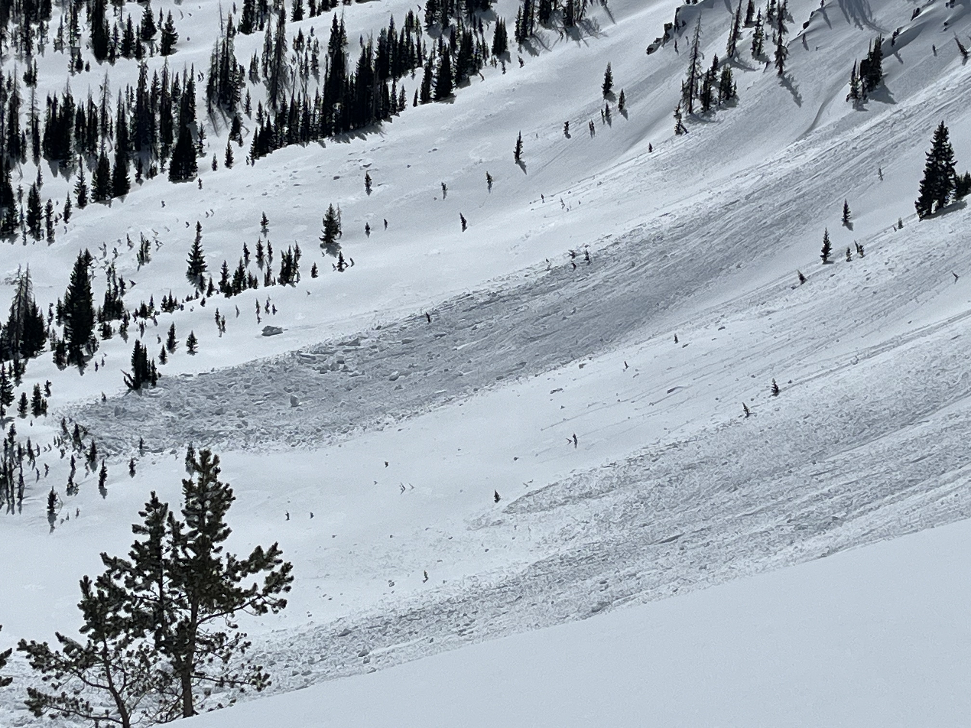
A variety of wet loose avalanches that occurred naturally on an easterly slope at about 9,000' yesterday afternoon. With continued heating today, expect more of the same.
Ad
Avalanche Problem #1
Wind Drifted Snow
Type
Location
Likelihood
Size
Description
Ted was out on the North Slope and mentions, "As they say at the drive up window; I will have the 'Super Size'. The cornices have grown quite large and are peeling off a few layers and depositing some decent debris piles on this heavily wind loaded ridgeline in Cataract Basin. Some of these triggered shallow slabs, but nothing too deep into old snow from my vantage point."
Northerly winds moved lightly with moderate gusts last night and will leave behind stubborn slabs of wind-drifted snow that exist many, if not all upper elevation slope. Today's drifts will be specific to high ridgelines and near terrain features like under cornices, gully walls, cliff-bands, subridges and slope convexities (rollovers). Watch for and avoid stiffer snow that appears smooth, chalky, and rounded, and pay attention when stomping around on it as it may sound hollow, like a drum. Stiffer slabs may allow you to get out on slope and make a few turns or trench a track before triggering it, while fresher, softer drifts will be more sensitive to our additional weight and easier to initiate.
A large cornice failed naturally during yesterday's warm up and stacked up a sizable amount of debris, certainly enough to put a working on a skier or rider.
Avalanche Problem #2
Persistent Weak Layer
Type
Location
Likelihood
Size
Description
The likelihood of triggering a persistent slab avalanche is decreasing, and most of our weak layers from early November all the way up until March are dormant. Although we are building confidence in the strength of the weak layers and structure of the snowpack there's still a small chance we could trigger a nasty slide. Here are some things to keep in mind that help me steer clear of the lingering weak snow and its avalanche problems:
  • We are not going to see obvious red flags like cracking, or hear big, booming collapses so don't put all your eggs in that basket.
  • If you pull out your probe and find a shallower area of the snowpack (100-175cms) dig around or trench down, you'll see this weak snow.
  • Where this problem exists is such a small and isolated portion of our terrain across the range, there is so much good riding to be had while avoiding the hazard.
  • Big triggers can produce big avalanches -- Watch out for cornice failure or rapid change, anything that could help pry out one of these nasty slides.
Additional Information
General Announcements
We are always looking for snow and avalanche observations or just general riding conditions. In the meantime reach out to us with questions, concerns, or if you see anything in your travels! Contact us directly through the info below:
This forecast is from the U.S.D.A. Forest Service, which is solely responsible for its content. This forecast describes general avalanche conditions and local variations always occur. This forecast was issued on Tuesday, March 25th at 06:00 AM and expires 24 hours after it was issued.