Donate to Our Spring Campaign or Bid on our Spring Auction to Support Forecasting

Forecast for the Uintas Area Mountains

Craig Gordon
Issued by Craig Gordon on
Sunday morning, March 23, 2025
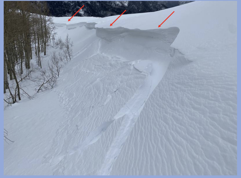
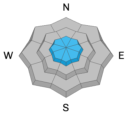
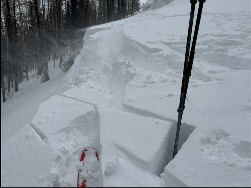
For today, in the windzone at and above treeline, you'll find pockets of MODERATE avalanche danger around the compass, especially on slopes with an easterly component to their aspect. Stiff, shallow drifts will react to our additional weight and human triggered avalanches are POSSIBLE. In addition, while becoming more the exception than the rule, human triggered slides breaking deeper and wider than we might expect are still possible in steep, rocky terrain or slopes that have avalanched multiple times season.
Most mid and lower elevation slopes facing the south half of the compass (solar) and lower elevation shady (polar) aspects offer generally LOW avalanche danger and human triggered avalanches are UNLIKELY.
Good news... the snowpack is becoming comfortable in its own skin and we're trending towards "open season"... let's just give it another minute or two and allow today's wind drifts to settle out before stepping into big, committing terrain.
Low
Moderate
Considerable
High
Extreme
Learn how to read the forecast here
Special Announcements
Our Spring Campaign is in full swing, and there are two great ways to support forecasting, awareness, and education across Utah: Donate to our Spring Campaign or bid on items in our Spring Auction
Every dollar helps keep the backcountry community on top. Thank you for your support!
Weather and Snow
Nowcast- Yesterday's moody weather delivered just an inch or two of high density snow with about .20" H2O... or in less technical terms....a spongy coat of white paint across the range. A band of high clouds drifts through the Uinta zone at o'dark thirty, but should filter out by about sunrise, revealing a stunning day for the eastern front. Temperatures register in the teens to mid 20's, while buzz-killing northwest winds blow in the 30's and 40's near the high peaks.
Forecast- A beautiful day is on tap with mostly sunny skies and temperatures climbing into the mid 40's. Northwest winds taper into upper 20's as the day wares on.
Futurecast- Spring be springin' this week! By Tuesday, max temperatures at 8000 feet soar into the low 60's with overnight lows hovering right at or just above freezing. The ridge of high pressure breaks down late in the week, ushering in the next cold front with a chance of snow sliding through on Friday.
Travel & Riding Conditions-
A local crew with a backyard view enjoying yesterday's creamy snow in wind sheltered terrain.
Recent Avalanches
Bo Torrey was in Upper Weber Canyon yesterday and reported tender cornices and shallow, yet sensitive wind drifts forming on steep, wind drifted, mid elevation terrain.
Ad
Avalanche Problem #1
Wind Drifted Snow
Type
Location
Likelihood
Size
Description
Andy found sensitive drifts yesterday in the Wolf Creek zone.
Winds have been all over the map and team up with a couple inches of snow to form fresh, dense drifts on the leeward side of upper elevation ridges and terrain features like chutes and gullies. Easy to identify by their fat, rounded appearance, these aren't particularly rowdy pieces of snow. However, don't let your guard down, especially in the windzone above treeline, where a fresh wind slab could definitely pack a bigger punch then you might've bargained for. You know the program... lose the wind and you lose the problem. Simply steer yourself away from rounded pillows of snow, especially if they sound hollow like a drum.
Avalanche Problem #2
Persistent Weak Layer
Type
Location
Likelihood
Size
Description
On Friday, visiting Canyons Village Avy Forecaster Tyler St. Jeor and I did our homework and felt comfortable getting into steep terrain we knew had a deep, homogenous, and stable snowpack.
Becoming more the exception than the rule, there's still an outside chance we can provoke the mostly dormant, persistent weak layers or PWL, especially in terrain that has remained thin all season like slopes that avalanched earlier this winter. Here's the deal and here's where it gets tricky... we're not going to see obvious red flags like cracking, or hear big, booming whoomphing sounds or experience heart-stopping collapses. However, if you do some detective work and trench down a bit in thin areas, you'll find weak, faceted snow buried a couple feet below the snow surface. We might forget about the layering, but the snowpack has an amazing memory.
Additional Information
  • We come to you with heavy hearts and great sadness this morning to confirm an avalanche accident on Friday, March 7th near Hoyt Peak, involving 51 year old Micheal Janulaitis from Marion, Utah. Micheal used a snowbike to access the terrain, but was caught, carried, and killed in an avalanche while skiing a steep, northeast facing run on Hoyt Peak.Huge thanks to the Department of Public Safety, Park City Mountain Resort and Canyons Village Snow Safety and Ski Patrol teams, along with Wasatch Backcountry Rescue for the hard work recovering Micheal and returning him to his family. Micheal was a friend of Utah Avy and we feel privileged for the time we got to spend together. This is a tremendous loss for our backcountry family and we will miss him deeply. We are compiling accident details and a preliminary report is available here.
General Announcements
We are always looking for snow and avalanche observations or just general riding conditions. In the meantime reach out to us with questions, concerns, or if you see anything in your travels! Contact us directly through the info below:
This forecast is from the U.S.D.A. Forest Service, which is solely responsible for its content. This forecast describes general avalanche conditions and local variations always occur. This forecast was issued on Sunday, March 23rd at 03:30 AM and expires 24 hours after it was issued.