Join us at our 2nd Annual Blizzard Ball

Forecast for the Uintas Area Mountains

Craig Gordon
Issued by Craig Gordon on
Friday morning, March 24, 2023
Heads up... avy danger ramps up as today's storm materializes-
For today, you'll find HIGH avalanche danger on steep, rocky, upper elevation, leeward slopes. Both natural and human triggered avalanches are VERY LIKELY on drifted slopes in the wind zone above treeline. Terrain facing the north half of the compass, especially steep slopes with an easterly component to its aspect have the potential to produce avalanches that'll pack a punch and easily roll you. CONSIDERABLE avalanche danger is found near treeline and human triggered avalanches are LIKELY on steep slopes with recent deposits of wind drifted snow. MODERATE avalanche danger develops at lower elevations and human triggered avalanches are possible on steep slopes as today's storm evolves.
Today's exit strategy... you can have a blast and score soft, surfy snow along with predictable avalanche danger in wind sheltered terrain with no overhead hazard.

Low
Moderate
Considerable
High
Extreme
Learn how to read the forecast here
Special Announcements
Thank you to everyone who donated to our Spring Campaign. We appreciate your support and look forward to creating new tools to help you stay safe in the backcountry.
Also... I am in the process of finalizing a report regarding the March 9th avalanche fatality in the Uinta's. Thank you for your patience... we will publish the final report in coming days.
Weather and Snow
Nowcast- Wow... March Madness was in full swing as yesterday's storm settled in the upper reaches of Chalk Creek and Weber Canyon, delivering a remarkable 17" of snow with .85 H2O in short order. Most other portions of the range couldn't hold a candle to those totals and are in the 8" range with about .40 H20. But in either case, that was so yesterday and as I live in the moment of this morning, skies are partly cloudy, temperatures register in the teens, and southwest winds blow 10-20 mph along the high ridges. With a deep, robust, go-anywhere base, riding and turning conditions live up to their 3 Star Michelin rating (5 Star on the Yelp Rating system :).
Forecast- A solid shot of snow is on our doorstep and should arrive in the next couple of hours. Look for a band of heavy snow to develop early this morning, turning showery by late afternoon... 10" by sunset seems reasonable. Temperatures claw into the upper teens and westerly winds increase into the 30's along the high ridges.
Futurecast- Scattered showers along with January-like temperatures are on tap for Saturday. A break in the action is slated to round out the weekend and begin the workweek.
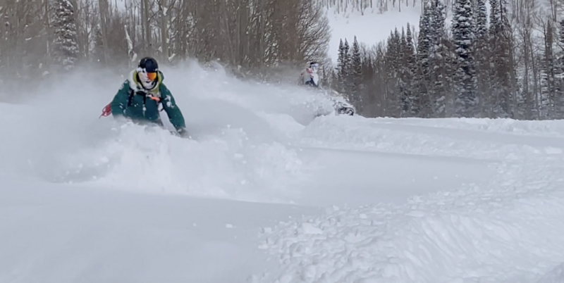
Over-the-hood and over-the-head.... avy-savvy, snow-pros Dave Kikkert and Andy Nassetta implementing some throttle therapy whilst product testing yesterday in a big open meadow with no overhead hazard.
Detailed trip reports and recent obs are found HERE.
Recent Avalanches
Yesterday's snowfall reaching nearly 5" an hour produced very tender shallow soft slabs which went from ridiculously easy to initiate, to hair trigger in just a matter of minutes as winds bumped just a titch... into the teens and low 20's. This was not only a special day to be out and about with a super solid crew, it was truly an amazing meteorological event to witness!
Plenty of avy activity to peruse if ya wanna geek out. Click HERE to track this years slide activity throughout the range.
Ad
Avalanche Problem #1
Wind Drifted Snow
Type
Location
Likelihood
Size
Description
Snow doesn't like rapid change and that was glaringly apparent as yesterday's storm settled in and lit up the terrain around Upper Weber Canyon, rapidly stacking up 10" of snow in a matter of a couple hours (17" storm totals since 17:00 hrs 3-22). We've got more snow and wind on the way and I think today's avalanches will have more meat on the bone, and once triggered, they're gonna pack a punch.
So... what's the strategy to manage the problem? Avoidance, of course! Yeah, as the storm gets underway, pump the brakes on the big terrain and tone down your objectives because I bet there's a piece of snow out there that'll break deeper and wider than we might expect. Steep, rocky, upper elevation, wind drifted slopes facing the north half of the compass are bulls-eye terrain today. Lose the wind and you lose the problem... plenty of great, wind sheltered riding options are found on lower angle slopes, especially those with no overhead hazard.

Avalanche Problem #2
New Snow
Type
Location
Likelihood
Size
Description
Snow piles up fast and furious and it'll be sensitive to our additional weight at all elevations so we'll wanna think about steep, snow covered slopes at all elevations. That means terrain right out of the gates near our trailheads and foothills.
Additional Information
Weather stations-
And... rime events from January's atmospheric rivers severely crippled the Uinta weather station network. I'm working to get it back up and running, but a few stations are found HERE (click weather stations, and then on the Western Uinta tab)
Over the weekend I visited our Currant Creek Snow site and of course... it was buried! I'm still trouble shooting comms and working to get everything back online.
Observations-
Your observations are important, so please let me know what you're seeing... click HERE and contribute to this amazing community-based program
General Announcements
Issued at 03:37 on Friday March 24th this forecast expires 24 hours after the date and time posted, but will be updated by 07:00 Saturday March 25th 2023.
Before it gets too crazy, now is the time to book an avalanche awareness presentation for your group, club, or posse. You can reach Craig directly at 801-231-2170 or [email protected].

This forecast is from the U.S.D.A. Forest Service, which is solely responsible for its content. This forecast describes general avalanche conditions and local variations always occur.