Forecast for the Uintas Area Mountains

Craig Gordon
Issued by Craig Gordon for
Wednesday, March 22, 2023
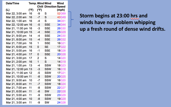
The storm is evolving and avalanche danger changed overnight-
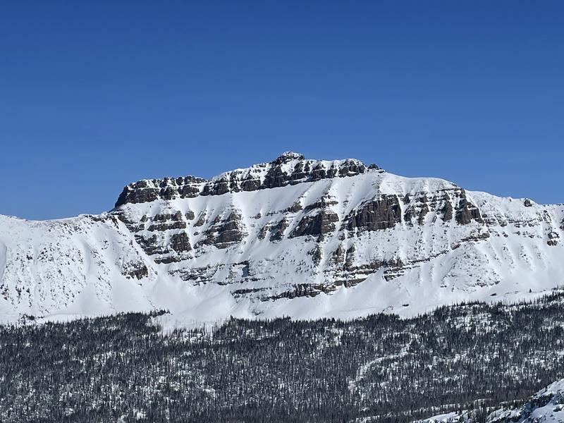
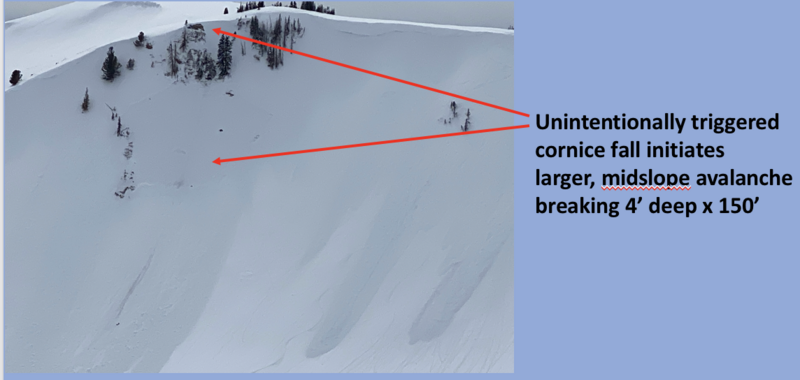
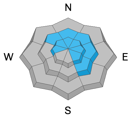
HIGH avalanche danger exists on steep, rocky, upper elevation, leeward slopes. Both human triggered and natural avalanches are VERY LIKELY on drifted slopes in the wind zone above treeline. Terrain facing the north half of the compass, especially steep slopes with an easterly component to its aspect have the potential to produce large, dangerous avalanches. CONSIDERABLE avalanche danger is found at treeline and human triggered avalanches LIKELY on steep slopes with recent deposits of wind drifted snow. Out of the wind you'll find more predictable MODERATE avalanche danger. Human triggered storm snow avalanches are POSSIBLE on all aspects and elevations.
Today's exit strategy... you can have a blast and score soft, surfy snow on lower elevation wind sheltered terrain with no overhead hazard.
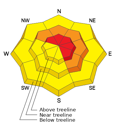
Low
Moderate
Considerable
High
Extreme
Learn how to read the forecast here
Special Announcements
Please consider donating to the spring campaign to help our team implement innovative tools and better provide you with the information you rely on
Weather and Snow
Nowcast-A band of moisture quickly slid through the region at the turn of the new day delivering and inch of dense, heavy snow near the trailheads, with nearly 4" in the high country. But it's the southerly winds ramping up overnight making headline news early this morning as they crank in the 50's and 60's along the high ridges. Temperatures are mild, hovering near freezing down low, cooling into the teens as you gain elevation. It might be a little rugged out there this morning, especially in the alpine, and I'd opt for mid or low elevation wind sheltered terrain which offer dense, surfy snow.
Forecast- Look for another band of snow sliding through our zone during the day with an additional 3"-6" stacking up. Southerly winds decrease somewhat, but remain a nuisance, blowing in the 30's and 40's near the ridges. Temperatures don't vary much from where we're at this morning.
Futurecast- Unsettled weather is on tap through Thursday before a rather unseasonably cold system slides into the area Friday. Yet another system follows suit late Saturday into Sunday.
I was in upper Weber Canyon yesterday and caught a rare break in the active weather pattern, which revealed a brief glimpse of a carbo-loading Hayden Peak... about as fat and white as it gets.
Ted was in the Whitney Basin and offers his sage advice and outstanding local knowledge in his trip report found HERE.
Detailed trip reports and recent obs are found HERE.
Recent Avalanches
An intriguing result from a large, tree breaking cornice as it crashes onto the slope below yesterday in Upper Weber Canyon.
Plenty of avy activity to peruse if ya wanna geek out. Click HERE to track this years slide activity throughout the range.
Ad
Avalanche Problem #1
Wind Drifted Snow
Type
Location
Likelihood
Size
Description
If you're looking for wind... you came to the right place. Above is a 24 hour data dump from Windy Peak (10,662')
The storm is evolving and avalanche danger changing as storm snow conspires with strong winds to produce dense drifts on leeward slopes. Here's where it's gonna get tricky... today's fresh wind slabs camouflage Monday's slabs and due to the strong overnight winds, the entire package may be lower downslope and hard to detect. The best way to manage the problem is by avoiding the problem. Simply steer clear of fat, rounded pieces of snow, especially if they sound hollow like a drum. In addition, I bet there's piece of snow out there that'll break deeper and wider than either you or I might expect. Steep, rocky, upper elevation, wind drifted slopes facing the north half of the compass still feel suspect to me. Lose the wind and you lose the problem... there's plenty of great, wind sheltered riding out there on lower angle slopes, especially those with no overhead hazard.

Avalanche Problem #2
New Snow
Type
Location
Likelihood
Size
Description
As storm snow stacks up rapidly, it'll become sensitive to our additional weight as the day wares on. Steep, snow covered slopes at all elevations get in on the act, so carefully evaluate the terrain you travel in today. That includes slopes near the trailheads and our foothills.
Additional Information
Weather stations-
And... rime events from January's atmospheric rivers severely crippled the Uinta weather station network. I'm working to get it back up and running, but a few stations are found HERE (click weather stations, and then on the Western Uinta tab)
Over the weekend I visited our Currant Creek Snow site and of course... it was buried! I'm still trouble shooting comms and working to get everything back online.
Observations-
Your observations are important, so please let me know what you're seeing... click HERE and contribute to this amazing community-based program
General Announcements
Issued at 03:37 on Wednesday March 22nd this forecast expires 24 hours after the date and time posted, but will be updated by 07:00 Thursday March 23rd 2023.
Before it gets too crazy, now is the time to book an avalanche awareness presentation for your group, club, or posse. You can reach Craig directly at 801-231-2170 or [email protected].

This forecast is from the U.S.D.A. Forest Service, which is solely responsible for its content. This forecast describes general avalanche conditions and local variations always occur.