March Kicks Off Our Spring Campaign- Donate Now to Support Forecasting

Forecast for the Uintas Area Mountains

Craig Gordon
Issued by Craig Gordon on
Monday morning, March 2, 2020
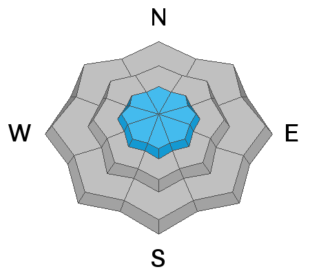
Today's avalanche danger is pretty straightforward and easily managed with terrain choices-
In the wind zone at and above treeline, fresh drifts will react to our additional weight and you'll find MODERATE avalanche danger. Human triggered avalanches are possible, especially on steep wind drifted slopes and particularly in terrain with an easterly component to its aspect.
Lose a little elevation, lose the wind, and you lose the problem. Wind sheltered terrain offers generally LOW avalanche danger and human triggered avalanches are unlikely.
Low
Moderate
Considerable
High
Extreme
Learn how to read the forecast here
Special Announcements
The UAC's Avy Awareness Auction is currently underway with tons of great gear, jewelry, artwork and experiences available. Visit the auction page here to help support the UAC's spring avalanche awareness and outreach efforts.
Click here for more details.
And... a new version of the UAC IOS application is now available on the Apple App Store. This version fixes many of the issues that occur when running IOS 13.
Click here for more details.
Weather and Snow
Currently-
A nice little storm developed over the region yesterday, delivering 6" of medium density snow across the range, with a few extra inches stacking up on the North Slope. Under mostly cloudy skies and a lingering snow shower or two, temperatures are cold, registering in the single digits and mid teens. Winds are light and northerly, blowing just 10-15 mph along the high peaks. With a welcome dose of fresh, white paint underfoot or machine, you'll appreciate a little cushion between you and the abundance of old, hard snow surfaces. Yup... riding and turning conditions are greatly improved, and low angle slopes are the ticket.
Uinta weather network info is found here. Simply click on the Western Uinta tab.
For today-
Look for mostly sunny skies, light winds, and temperatures climbing into the upper 20's and low 30's. Overnight lows under clear skies dip into the teens.
Futurecast-
Looks like we dry out and warm up this week with no major storms in sight.
Recent Avalanches
No significant avalanche activity to report.
To view additional trip reports and recent avalanche activity, simply click here.
Ad
Avalanche Problem #1
Wind Drifted Snow
Type
Location
Likelihood
Size
Description
Fresh wind drifts along the leeward side of upper elevation ridges will react to our additional weight and in the wind zone, may break a bit deeper and wider than you'd expect. In addition, there are some hard, slick crusts for avalanches to run on and today's slides may travel further and faster than you might expect. The good news is... today's drifts will predictably break at or below our skis, board, or sled. But remember... if you're tagging steep, technical terrain, be aware that even a small slide could knock you off your feet and boss you around. So, the ticket to riding safely today is simply look for and avoid any fat, rounded piece of snow, especially if it sounds hollow like a drum.
Additional Information
Ryan shared an image from yesterday's outing in Whitney Basin, where it looks like his hybrid access worked out rather well for a day of mixed approach riding and turning.... good on ya.
General Announcements
The information in this forecast expires in 24 hours, but will be updated by 7:00 AM Tuesday Mar. 3rd.
This forecast is updated daily by 7:00 AM.
In the mean-time, if you see or trigger an avalanche or just wanna let me know what you're seeing you can reach me directly at 801-231-2170
This is a great time of year to schedule one of our free avy awareness presentations.
You can email me directly [email protected]
The information in this forecast is from the US Forest Service which is solely responsible for its content.