March Kicks Off Our Spring Campaign- Donate Now to Support Forecasting

Forecast for the Uintas Area Mountains

Craig Gordon
Issued by Craig Gordon on
Thursday morning, March 18, 2021
Heads up... the avalanche danger is slightly more pronounced around Bald Mountain which received the most snow from Monday's storm
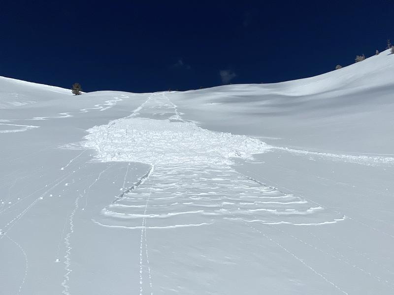
Strong, spring sunshine will cook the snow surface and the danger for wet avalanches increases to MODERATE as the day progresses. HUMAN TRIGGERED WET SNOW AVALANCHES ARE POSSIBLE on steep sun baked slopes, especially during the heat of the day.
Upper elevation terrain in the wind zone, at and above treeline, delivers MODERATE avalanche danger on steep, wind drifted, leeward slopes and HUMAN TRIGGERED DRY SNOW AVALANCHES ARE POSSIBLE. Steep, rocky terrain facing the north half of the compass remains suspect and while more the exception than the rule, any avalanche that breaks to weak layers of snow near the ground results in a deep, dangerous avalanche that'll instantly ruin your day.
Mid and low elevation terrain, especially slopes facing the north half of the compass offer generally LOW avalanche danger. Remember- low avalanche danger doesn't mean no avalanche danger, so please continue practicing your safe travel rituals and make sure you carry and know how to use your avalanche rescue gear.... transceiver, shovel, and probe.
Low
Moderate
Considerable
High
Extreme
Learn how to read the forecast here
Special Announcements
Our Spring Avy Awareness Campaign is in full swing from March 16th- March 30th. Please help us save lives through avalanche forecasts and education. Consider making a donation to show your support.
Weather and Snow
Trenchtown rock... Bald Mountain and Mirror Lake got pounded by Monday nights storm, where Ted found over-the-hood and over-the-head riding on Tuesday. More on his travels and an excellent ob found HERE.
Nowcast-
High clouds drifted into the region overnight and temperatures are relatively mild, currently registering in the upper teens and mid 20's. A slight bump in southerly winds right around dinnertime lingered through midnight, but at o'dark thirty there's hardly a breath of wind even along the high peaks. Riding and turning conditions vastly improved in the wake of Monday nights storm which delivered 10"-20" of snow across the range, but the terrain around Mirror Lake acted as a catchers mitt, piling up the highest amounts of cold, white, fluff. But... that was so Tuesday and all but the highest north facing terrain took on heat and most slopes have varying degrees of surface crust.
Forecast-
Skies clear later this morning and we can expect mostly sunny skies, light winds, and high temperatures climbing into the 30's and low 40's.
Futurecast-
The warm before the storm. By Friday afternoon, winds increase and temperatures soar ahead of a good refresh slated for the weekend. Look for snow developing Saturday, lingering into Sunday with 6"-8" a good bet by Sunday afternon. A break for early Monday and a slightly colder storm slated for Monday night and Tuesday.

Looking for real-time temps, snow, or wind?
Click here and then on the "western Uinta" tab for western Uinta specific, weather station network.
Recent Avalanches
On Tuesday, avy pros Bill Nalli and Dave Kikkert reported that just a little bit of morning sun instantly brought the cold storm snow to life. More on their travels found HERE.
Observations, trip reports, and avalanches found here.
Ad
Avalanche Problem #1
Wet Snow
Type
Location
Likelihood
Size
Description
Most of our terrain got kissed by the sun and is shrink-wrapped this morning. But ya know it's spring and the sun is high in the sky. If you find yourself feeling like an ant under a magnifying glass, so is the snow. It doesn't mean you need to blow off a good spring powder day, but it does mean that if you find the snow getting damp, you should switch to a cooler aspect. And remember, while slow moving, wet avalanches stack up huge piles of tree snapping debris, so you'll want to avoid terrain traps like gullies and road cuts.
Avalanche Problem #2
Persistent Weak Layer
Type
Location
Likelihood
Size
Description
The snowpack is getting comfortable in its own skin and that's good news in terrain where the snowpack is deep. However, snow is a curious medium and all we need to do is find one inconsistency or a shallow zone, maybe around a rock or bush, collapse the pack, and now we've got a bigger slide than we might've bargained for. So my safe travel strategy is to think about suspect terrain I want to continue avoiding and that includes steep, rocky terrain and slopes that avalanched near the ground earlier in the season. And here's something to consider... we've got a "go anywhere" base, so if you're getting into steep, technical terrain, remember that even a small slide can knock you off your ride, slam you into a tree, and throw a curve ball at your day.
Additional Information
I will update this forecast by 7:00 AM tomorrow, Friday, March 19th.
Your observations are important, so please let me know what you're seeing... click HERE and contribute to this amazing community based program
General Announcements
If you see or trigger an avalanche or just wanna let me know what you're seeing you can reach me directly at 801-231-2170 or [email protected]
This forecast is from the U.S.D.A. Forest Service, which is solely responsible for its content. This forecast describes general avalanche conditions and local variations always occur.