Forecast for the Uintas Area Mountains

Paige Pagnucco
Issued by Paige Pagnucco on
Thursday morning, March 12, 2026

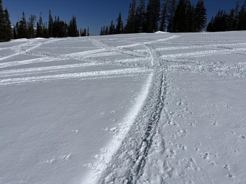
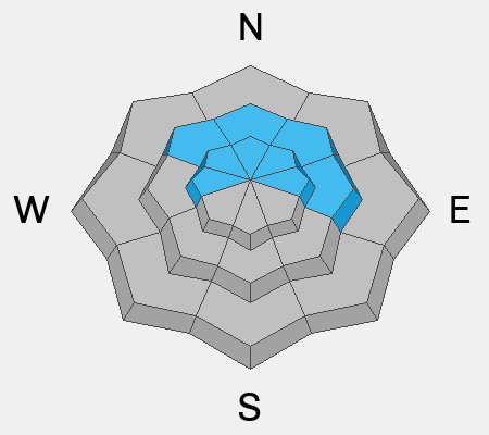
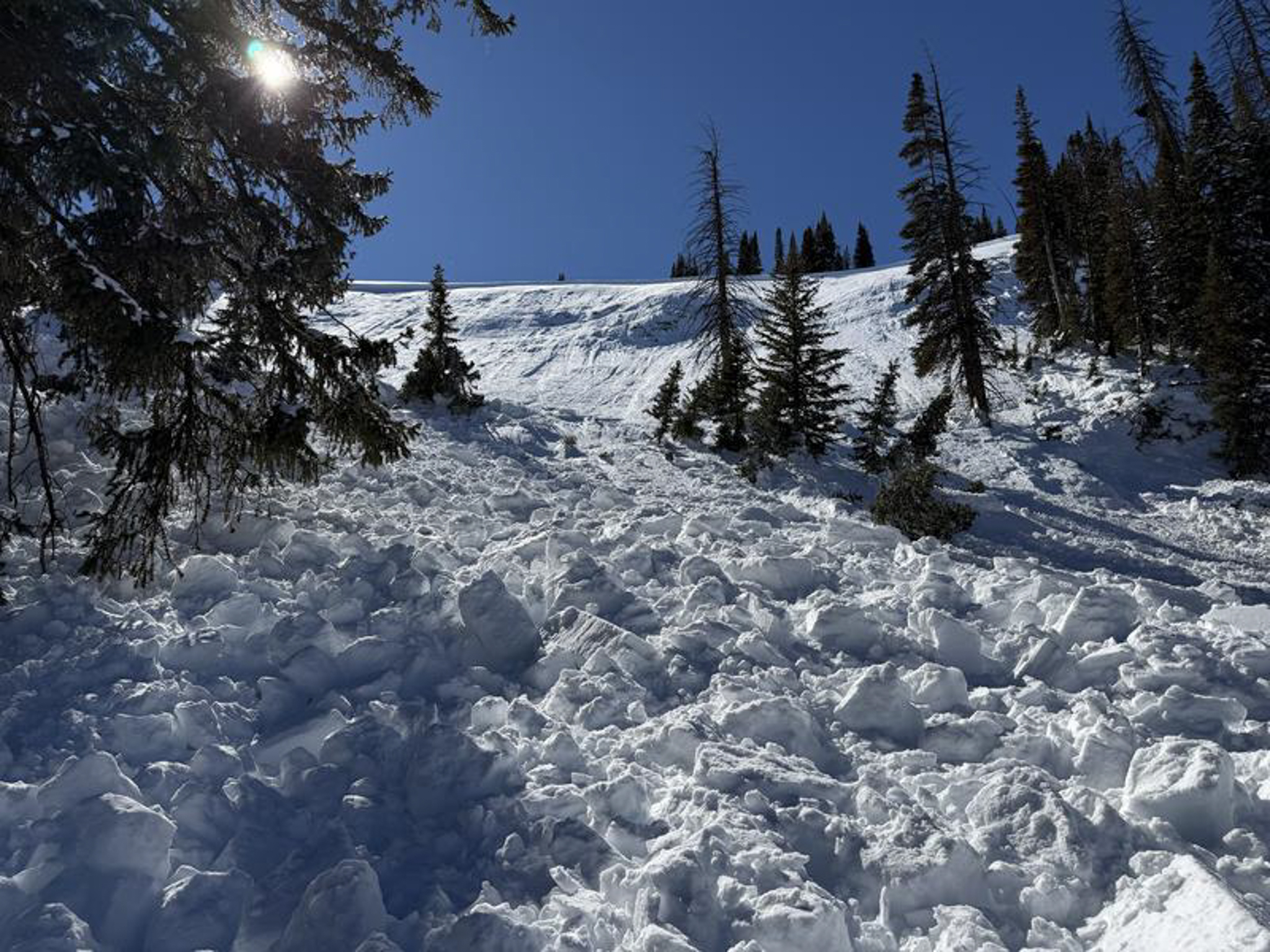
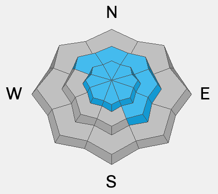
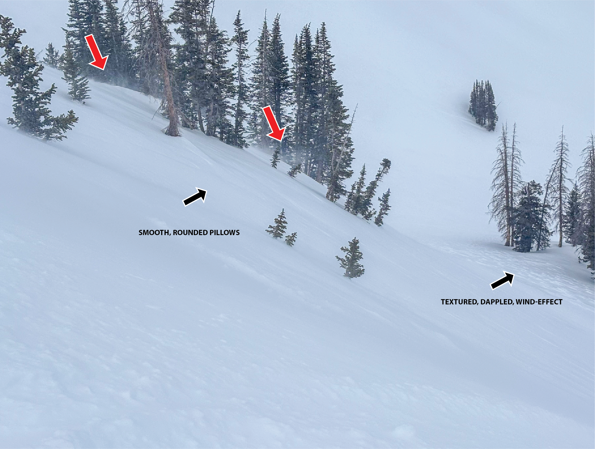
Pockets of CONSIDERABLE avalanche danger exist, especially on steep, rocky upper-elevation slopes facing northwest through east, where triggering an avalanche is likely. Large and destructive hard slabs may be triggered remotely—from a distance, below the slope, or from connected low-angle terrain—and will fail on weak, sugary faceted snow from the January dry spell. Continuing strong winds will drift snow into steep leeward terrain.

Cautious route-finding, conservative decision-making, and careful snowpack evaluation are essential for safe travel.

Low
Moderate
Considerable
High
Extreme
Learn how to read the forecast here
Weather and Snow

You'll have to work to find areas of soft snow, as the sun and wind have done significant damage to the surface in exposed terrain over the past few days. Low-angle, upper-elevation, sheltered, and shady northerly terrain is your best option (not connected to or near steep slopes) for finding any remaining cold snow. The snow surface is supportable most everywhere, though take caution when crossing low- and mid-elevation snow bridges over creeks, as they are beginning to soften and lose integrity.

This morning, 10,000-foot temps are near 25°F with winds blowing from the west in the 20s mph and gusts a bit higher. Expect a sunny but warm and windy day today with temperatures breaching 32°F around 10,000' and winds blowing from the west 20 to 25 mph, then increasing to 25 to 30 mph in the afternoon, with gusts in the 40s mph. Wind chills will be in the single digits F. Hold on to your helmets!

Tomorrow will be similar, with continued warm and windy conditions ahead of a small system expected to arrive Saturday and Saturday night, bringing a few inches of snow.

Snow surface near Wolf Creek is supportable but very rough and firm.

Recent Avalanches

No avalanches were reported yesterday, Find all Uintas observations HERE.

Avalanche Problem #1
Persistent Weak Layer
Type
Location
Likelihood
Size
Description

The snowpack is complex, with weak, sugary faceted snow from January sitting underneath multiple feet of denser snow from the past few weeks. Strong snow over weak snow is a classic setup for avalanches. Obvious red flags like collapsing and cracking may be absent, and you may even get a few sets of tracks on the slope before finding the right trigger spot, often a shallower part of the slab near rocks or bushes. These avalanches have the potential to be large and destructive.

While not widespread, this problem is impossible to navigate. The only way to deal with a persistent weak layer is to avoid it - steep and rocky slopes with shallow snow on the north half of the compass are off limits for now.

The slide on Duchesne Ridge produced SUV-size chunks of debris, which stacked up deep in the runout and in the trees below. Getting caught in a dangerous slide like this could be game over -- Trees turn into baseball bats, and debris chunks are like boulders coming down on you.

Avalanche Problem #2
Wind Drifted Snow
Type
Location
Likelihood
Size
Description

The wind has been and will continue to be relentless - with a Wind Advisory in effect for today, expect slabs of wind-drifted snow to develop in leeward terrain and around terrain features like gullies, rock outcrops, subridges, and mid-slope rollovers. These smooth, rounded pillows will feel hollow underfoot and may let you get well out onto them before suddenly releasing. Cracking and collapsing may not be present. Remember, any avalanche triggered can step down into buried weak layers within the snowpack, triggering a larger avalanche than expected.

It's easy to avoid this problem by staying out of the wind zone and not traveling on steep slopes holding rounded, textured pillows of snow.

Red arrows indicate rolling snow that is loading leeward slopes at mid and upper elevations. The black arrows indicate a few things to look for when identifying and avoiding today's hazard.

Additional Information
Our Avalanche Rescue Training Park is set-up and located at the top of Wolf Creek Pass, SR-35, and is waiting for you to come take it for a spin! Open up the control unit, flip a few switches, and dial in your avalanche rescue skills with this roadside attraction!
More details about the WCP Beacon Park, here!

General Announcements

We have some upcoming classes and events that we'd be stoked to see you at -- Please reach out with any questions and check out below for more details!

We are always looking for snow and avalanche observations or just general riding conditions. Reach out to us with questions, concerns, or if you see anything in your travels! Contact us directly through the info below:

This forecast is from the U.S.D.A. Forest Service, which is solely responsible for its content. This forecast describes general avalanche conditions, and local variations always occur. This forecast was issued on Thursday, March 12, at 7:30 AM and expires 24 hours after it was issued. We'll update this information by about 7:30 AM tomorrow.