Forecast for the Uintas Area Mountains

Mark Staples
Issued by Mark Staples for
Friday, March 11, 2022
WATCH OUT - Conditions are unusually dangerous for this time of year. Beautiful weather and great powder can fool us into thinking conditions are safer than they are.
Human triggered avalanches are likely today and the avalanche danger is CONSIDERABLE on all slopes (even well below treeline) facing NW, N, NE, and E. Also, any wind loaded slope above treeline has a CONSIDERABLE danger.
Slopes facing west and south near and below treeline generally do not have a weak layer of facets, but with so much new snow, avalanches on theses slopes remain possible and the danger is MODERATE.
Low
Moderate
Considerable
High
Extreme
Learn how to read the forecast here
Special Avalanche Bulletin
Unusually late winter avalanche conditions exist and avalanche danger remains elevated.
Deep, dangerous, and potentially deadly slides breaking several feet deep and hundreds of feet wide can be triggered from a distance and low on the slope.
Avoid being on, near, or below steep wind drifted, mid and upper elevation slopes, especially those facing the north half of the compass.
Weather and Snow
NOWCAST-
Very cold temperatures this morning range from -8 to 0 degrees F under clear skies. Winds are blowing from the north. At upper elevations, they are blowing 20-35 mph gusting to 43 mph. Below treeline, winds are blowing 4-7 mph gusting 10-20 mph.
FORECAST-
Today will be clear and sunny and temperatures may only warm to the teens F, but it should feel a lot warmer in the sun. Winds should calm a little bit and blow from the northwest.
FUTURECAST-
Saturday will be clear, sunny, and quite a bit warmer. Clouds move over the area Sunday morning and should deliver 2-4 inches of snow Sunday afternoon & evening with a quickly moving storm. Ridging builds again Monday and Tuesday followed by another shot of snow Wednesday.
Conditions are fantastic now with about 12 inches of snow from Wednesday and 9 inches of snow from early in the week.
Trip reports and snowpack observations are found HERE.

Looking for real-time temps, snow, or wind? Click HERE and then on the "western Uinta" tab for western Uinta specific, weather station network.
Recent Avalanches
There has been a lot of avalanche activity in northern Utah, and I suspect we'll hear about more slides today and tomorrow. Yesterday in the mountains above Bountiful, which have a similar snowpack situation, a rider was caught in a slide but not buried or hurt (photo below of the debris and his sled). His group was equipped with avalanche rescue gear and going one at a time. Watch a video of it HERE.
A group riding on the north slope of the Uintas near Double Hill observed a bunch of cracking which tells me they would have triggered avalanches if they had been riding on steeper slopes.
Two days ago near Smith & Moorehouse Reservoir, I observed widespread collapsing, cracking and lots of mini avalanches along creeks as well as one very large, naturally triggered slide.

Your input is vital and we're interested in what you're seeing. Please contribute to this great community resource and go here to fill out an observation.
Ad
Avalanche Problem #1
Persistent Weak Layer
Type
Location
Likelihood
Size
Description
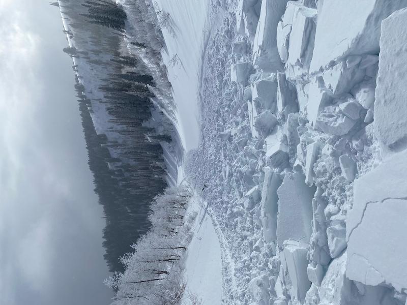
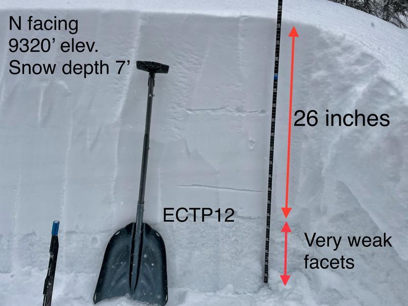
There is a persistent weak layer of faceted snow buried 2 feet deep that will fracture and produce avalanches today. Think of it like a layer of dominoes under snow from the last few storms. When your skis or track tip the first domino, it sets off a chain reaction in which all the dominoes (aka the weak layer) collapse, and that allows the slab of snow on top to crash downhill. You only have to be near a steep slope (at the top, bottom, or to the side) to tip one of the dominoes and trigger a slide.
What makes this situation tricky?
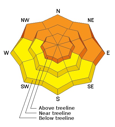
  1. We don't normally deal with long lasting avalanche problems like this in this part of the winter. These avalanches will act more like early and mid season slides that break on faceted or sugar snow near the ground except in this case avalanches will break in the middle of the snowpack. These slides will also break in areas below treeline where we don't often expect to see as many avalanches.
  2. You can trigger one of these slides by simply being near a steep slope but not necessarily on it.
  3. This weak layer is on many slopes but not all. OR, it may be on one part of slope but not the other. This means you may see people ride a slope and not trigger a slide. The second or third person on a slope may be the one to trigger it, OR you may not trigger a slide until you go onto a different slope.
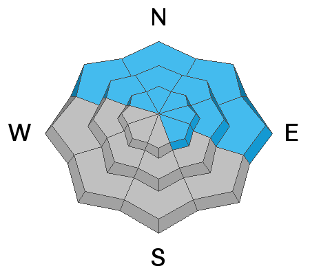
What to do? There are two options. Ride southerly facing slopes that don't have this weak layer, but the problem is they have a much thinner snowpack. Other slopes with a deeper snowpack and better powder likely have this weak layer and will be unstable. In those areas, ride slopes less than 30 degrees in steepness with nothing steeper above you (avalanches don't happen on slopes less than 30 degrees but it takes training and practice to identify those with your eyes; otherwise, you have to measure them with an slope measuring app).
Notice the layer of granular, weak, sugary faceted snow in the photo below.
Avalanche Problem #2
Wind Drifted Snow
Type
Location
Likelihood
Size
Description
Winds turned and have been blowing from the north this morning. At upper elevations above treeline, they have likely been forming some soft slabs of wind drifted snow that could be triggered today. This drifting has likely top loaded south and east facing slopes and cross loaded north and west facing slopes. See the image be
Example of locations of "top loading"
Example of locations of "cross loading"
Additional Information
Your observations are important, so please let me know what you're seeing... click HERE and contribute to this amazing community based program
General Announcements
The information in this forecast expires 24 hours after the day and time posted, but will be updated by 07:00 Friday, March 11th.
Before it gets too crazy, now is the time to book an avalanche awareness presentation for your group, club, or posse. You can reach me directly at 801-231-2170 or [email protected]
This forecast is from the U.S.D.A. Forest Service, which is solely responsible for its content. This forecast describes general avalanche conditions and local variations always occur.