Forecast for the Uintas Area Mountains

Craig Gordon
Issued by Craig Gordon for
Thursday, March 10, 2022
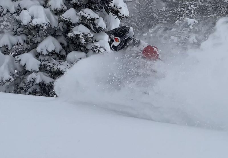
HEADS UP... this is an unusually sketchy snowpack setup for us this deep into the winter, weak layers of snow teeter on the edge, and the avalanche danger remains elevated.
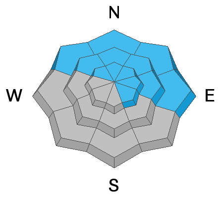
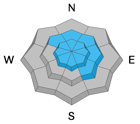
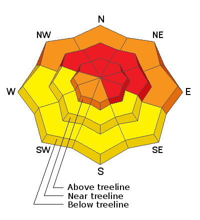
HIGH avalanche danger exists near and above treeline, where recent wind drifts rest on top of a pre-existing, weak layer of sugary snow. Both natural and human triggered slides breaking deeper and wider than you might expect are VERY LIKELY, especially on steep slopes facing the north half of the compass and particularly those with an easterly component to their aspect.
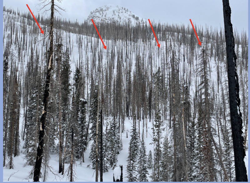
Even lower elevation terrain below treeline offers no shortage of weak, sugary snow where CONSIDERABLE avalanche danger is found and human triggered avalanches are LIKELY on steep, shady slopes near our trailheads.
Shift compass orientation to terrain facing south and you'll find more predictable avalanche conditions involving fresh storm snow. MODERATE avalanche danger is found on sustained steep, southerly slopes and human triggered avalanches are POSSIBLE.

Low
Moderate
Considerable
High
Extreme
Learn how to read the forecast here
Special Avalanche Bulletin
Unusually late winter avalanche conditions exist and avalanche danger remains HIGH.
Deep, dangerous, and potentially deadly slides breaking several feet deep and hundreds of feet wide can be triggered from a distance and low on the slope.
Avoid being on, near, or below steep wind drifted, mid and upper elevation slopes, especially those facing the north half of the compass.
Travel in avalanche terrain in not recommended.
Weather and Snow
NOWCAST-
The last gasp of storminess slides through the region, delivering high clouds, scattered snow showers, and very cold, diesel-gelling temperatures registering right around zero with some sites cratering to -8 degrees. Add in westerly winds blowing 10-20 mph and you've got brutal windchill clocking in at -25 degrees. But wait... there's more! Recent storms provide over-the-hood and over-the-head snow and five star riding conditions make you instantly forget about your numb fingers and toes.
FORECAST-
Expect clearing skies, light winds, and very cold daytime highs barely crawling into the mid teens. Westerly winds shouldn't get too out of hand, averaging in the 20's along the high ridges. Generally clear skies by late in the day allow temperatures to crash into negative territory tonight.
FUTURECAST-
Slight warming is on tap for Friday and then the heat is on especially for Sunday as a strong ridge develops overhead. More storminess for the midweek period.
Yesterday's storm stacked up a solid 12" of snow with about an 1" of H2O and yup... it's that DEEP!
Trip reports and current state of the snowpack observations are found HERE.

Looking for real-time temps, snow, or wind?
Click HERE and then on the "western Uinta" tab for western Uinta specific, weather station network.
Recent Avalanches
Mark and Weston D rode in Smith-Moorehouse yesterday and found no shortage of recent avalanche activity. Breaking a couple feet deep and hundreds of feet wide, the naturally triggered avalanche in the image above illustrates the type of avalanche dragon we're dealing with. Their trip report is found HERE.

Your input is vital and we're interested in what you're seeing. Please contribute to this great community resource and go here to fill out an observation.
Ad
Avalanche Problem #1
Persistent Weak Layer
Type
Location
Likelihood
Size
Description
Make no mistake, this is an unusual snowpack setup for us and we need to pump the brakes and re-evaluate the type of terrain we generally get after in the spring-
Here's what's going on... weak layers of sugary snow developed on the surface of the snowpack during the January/February dryspell. Yes, the livin' was easy and it was great recycled powder or what we call near surface faceted snow (NSF).
Here's the problem... NSF is a weak layer that's now buried and preserved several feet under the snow surface.
Now here's the bad news... with a strong shot of testosterone, our new problem child is channeling its rowdy teenage years, coming out of its awkward dormancy and back to life. In fact, just looking at the snowpack the wrong way this week sparked it to come unglued and that's when hardly any additional water weight, wind, or new snow was added to this fragile weak layer. And now it's getting a big thump and teetering on the edge. Let's face it, we're not going to outsmart the avalanche dragon, so avoidance is the big ticket item. Simply avoid where it lives and that means steering clear of steep terrain which faces the north half of the compass.
Avalanche Problem #2
Wind Drifted Snow
Type
Location
Likelihood
Size
Description
Above is a 24 hour data dump from Windy Peak (10,661') illustrating strong ridgetop winds.
Upper elevation winds have been all over the map and they're having no problem whipping up a fresh round of drifts that'll be reactive to our additional weight today. Here's the curve ball... fresh wind drifts form lower downslope than you might expect, stack up on a variety of old snow surfaces, and some are quite hard and slick. Any avalanche triggered on a sustained steep slope may run further and faster than you might expect.
Avalanche Problem #3
New Snow
Type
Location
Likelihood
Size
Description
The new snow is settling, but may still react to our additional weight, stacking up more debris that you'd anticipate, especially if its channeled into a terrain trap like a gully or creek bottom.
Additional Information
Your observations are important, so please let me know what you're seeing... click HERE and contribute to this amazing community based program
General Announcements
The information in this forecast expires 24 hours after the day and time posted, but will be updated by 07:00 Friday, March 11th.
Before it gets too crazy, now is the time to book an avalanche awareness presentation for your group, club, or posse. You can reach me directly at 801-231-2170 or [email protected]
This forecast is from the U.S.D.A. Forest Service, which is solely responsible for its content. This forecast describes general avalanche conditions and local variations always occur.