Forecast for the Uintas Area Mountains

Craig Gordon
Issued by Craig Gordon for
Saturday, March 12, 2022
HEADS UP -
Deceptively dangerous avalanche conditions exist for this time of year, especially on slopes facing the north half of the compass. Here's the catch... sunny skies, fresh snow, and outstanding late season riding lure us into thinking conditions are safer than they are and we're good to go. The snowpack isn't sharing our same emotions.
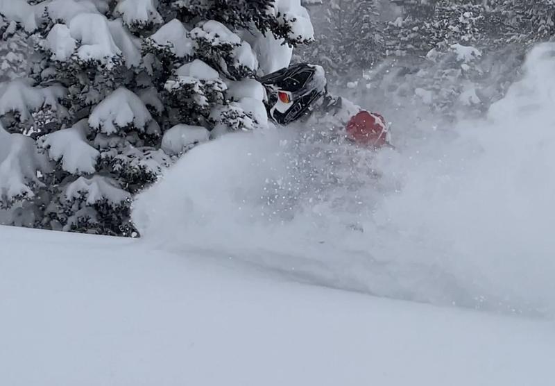
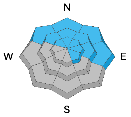
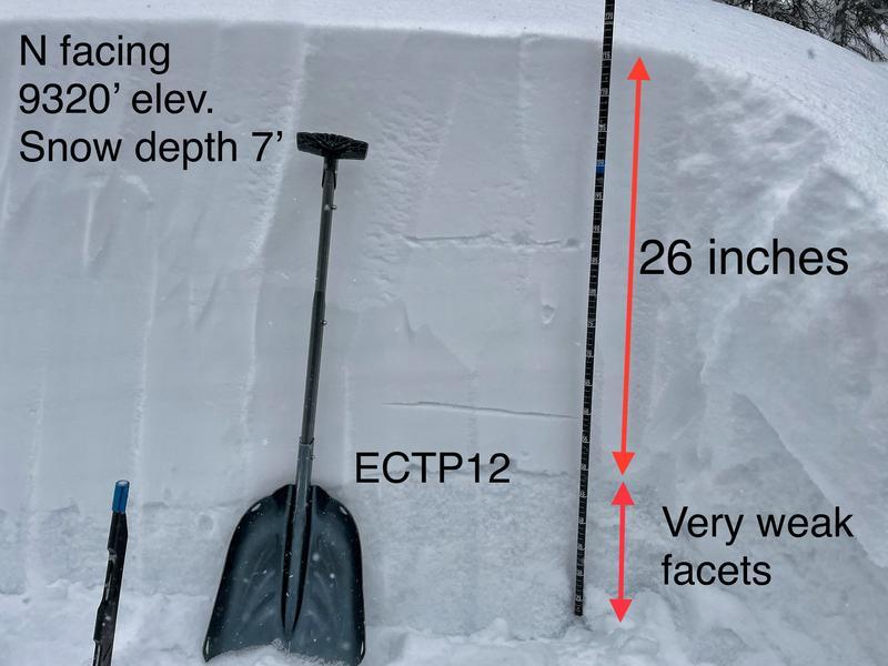
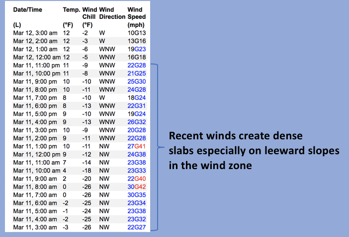
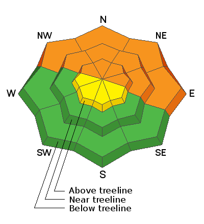
CONSIDERABLE avalanche danger exists today. Dangerously deep, human triggered avalanches are likely on all slopes (even well below treeline) facing NW, N, NE, and E, especially those with recent deposits of wind drifted snow. Any avalanche that breaks to old snow has the potential to deliver a devastating curve ball to your day.
Slopes facing west and south near and above treeline generally do not have a weak layer of facets, but with so much new snow, avalanches on theses slopes remain possible and the danger is MODERATE.
Looking for LOW avalanche danger? Well, then you've got plenty of options. Simply steer towards mid and lower elevation sunny slopes or choose a big, open meadow with no steep slopes above or adjacent to where you're riding.
Low
Moderate
Considerable
High
Extreme
Learn how to read the forecast here
Special Avalanche Bulletin
The Utah Avalanche Center is issuing a SPECIAL AVALANCHE BULLETIN for Saturday, March 12, 2022. We are very worried that a serious avalanche accident could occur this weekend. A CONSIDERABLE avalanche danger exists across northern and central Utah -THIS IS WHEN WE SEE THE MOST ACCIDENTS AND FATALITIES.
DANGEROUS AVALANCHE CONDITIONS combined with great powder and beautiful weather make accidents likely. There have been many close calls this week, but luck eventually runs out. We commonly see a string of close calls leading up to serious accidents.
Two key messages:
Ensure everyone wears and knows how to use an avalanche beacon, shovel, and probe.
Avoid being on, near or under all steep slopes and avalanche terrain. There is great riding and great powder on slopes less than 30 degrees in steepness where avalanches generally don’t occur.
Weather and Snow
NOWCAST-
Scattered high clouds drift over the region this morning, providing a textured backdrop to our big peaks. Temperatures climb out of the deep freeze and register in the teens and low 20's which is nearly 15 degrees warmer than at this time (03:00) yesterday morning. Northwest winds tapered off right around midnight and currently blow just 10-15 mph even along the high ridges. Outstanding late winter conditions await your arrival.
FORECAST-
A stunning day is on tap with mostly sunny skies, light winds, and temperatures climbing into the mid 30's. Overnight lows dip into the low 20's.
FUTURECAST-
A fast moving storm crosses the area Sunday, bringing a few inches of snow before high pressure returns Monday. Another small storm is on tap for a midweek refresh.
Recent storms delivered nearly two feet of deep, light snow that'll make our license plates proud... but get out and get after it early, cause it's spring after all and that cold snow is gonna take on heat.
Trip reports and snowpack observations are found HERE.

Looking for real-time temps, snow, or wind? Click HERE and then on the "western Uinta" tab for western Uinta specific, weather station network.
Recent Avalanches
There's no shortage of avalanche activity in northern Utah, and I suspect we'll hear about more slides by days end. Above is a viddy from Thursday in the mountains above Bountiful, which have a similar snowpack setup. A rider was caught in a slide but not buried or injured. His group was equipped with avalanche rescue gear, going one at a time, and everyone comes home at the end of the day.
A group riding on the north slope of the Uintas near Double Hill observed a bunch of cracking which tells us they would have triggered avalanches if they had been riding on steeper slopes.
Earlier in the week near Smith & Moorehouse Reservoir, Mark observed widespread collapsing, cracking and lots of mini avalanches along creeks as well as one very large, naturally triggered slide.

Your input is vital and we're interested in what you're seeing. Please contribute to this great community resource and go here to fill out an observation.
Ad
Avalanche Problem #1
Persistent Weak Layer
Type
Location
Likelihood
Size
Description
Here's the deal-
A persistent weak layer or what we call near surface faceted snow (NSF) is now buried two feet deep, blanketed by this weeks storm snow. The problem is... we've got an unusual, late season, strong snow on top of weak snow setup. And the weak layer is easily failing under our additional weight and will produce deep, dangerous avalanches today. Think of the NSF like a layer of dominoes with stronger snow resting on top. When your skis or track tip the first domino, it sets off a chain reaction in which all the dominoes (aka the weak layer) collapse, pulling the rug out from underneath, and the entire roof crashes down on us! Here's where it gets tricky... we don't even need to be on a steep slope, just near or connected to it (at the top, bottom, or to the side). Tip one of the dominoes over and now we're staring down the barrel of a scary avalanche!
What makes this situation tricky?
  1. We don't normally deal with long lasting avalanche problems like this, lingering deep into the winter. Today's avalanches act more like early and mid season slides that break on sugary snow near the ground except in this case avalanches will break in the middle of the snowpack. Avalanches may also break in areas below treeline where we don't often expect to see as many slides.
  2. You can trigger deep, dangerous avalanches by simply being near a steep slope but not necessarily on it.
  3. This weak layer is found on many slopes but not all, especially in the wind zone, where distribution is spotty and that make stability patterns tricky to get a handle on. So... you might find weak snow on one part of a slope but not the other. This means you may see people ride a slope and not trigger a slide, but the second or third person on that same slope may be the one to trigger and avalanche.
What to do? There are two options. Ride southerly facing slopes that don't have this weak layer, but the problem is they have a much thinner snowpack. Terrain facing the north half of the compass offers a deeper snowpack and cold powder, but likely have this weak layer and are unstable. In those areas, simply ride slopes less than 30 degrees in steepness with nothing steeper above you (avalanches don't happen on slopes less than 30 degrees but it takes training and practice to identify those with your eyes; otherwise, you have to measure them with an slope measuring app).
Notice the layer of granular, weak, sugary faceted snow in the photo below.
Avalanche Problem #2
Wind Drifted Snow
Type
Location
Likelihood
Size
Description
Above is a 24 hour data dump from Windy Peak (10,661') illustrating recent wind trends.
West and northwest winds have been busy at work, forming shallow, stiff wind drifts that'll remain reactive to our additional weight today. Found mostly on south facing, leeward terrain in the wind zone above treeline, also be on the look out for fresh drifts that formed in terrain features like chutes and gullies. Lose the wind and you lose the problem.
Additional Information
Your observations are important, so please let me know what you're seeing... click HERE and contribute to this amazing community based program
General Announcements
The information in this forecast expires 24 hours after the day and time posted, but will be updated by 07:00 Sunday, March 13th.
Before it gets too crazy, now is the time to book an avalanche awareness presentation for your group, club, or posse. You can reach me directly at 801-231-2170 or [email protected]
This forecast is from the U.S.D.A. Forest Service, which is solely responsible for its content. This forecast describes general avalanche conditions and local variations always occur.