Donate to Our Spring Campaign or Bid on our Spring Auction to Support Forecasting

Forecast for the Uintas Area Mountains

Andrew Nassetta
Issued by Andrew Nassetta on
Monday morning, March 10, 2025
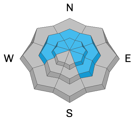
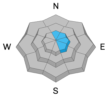
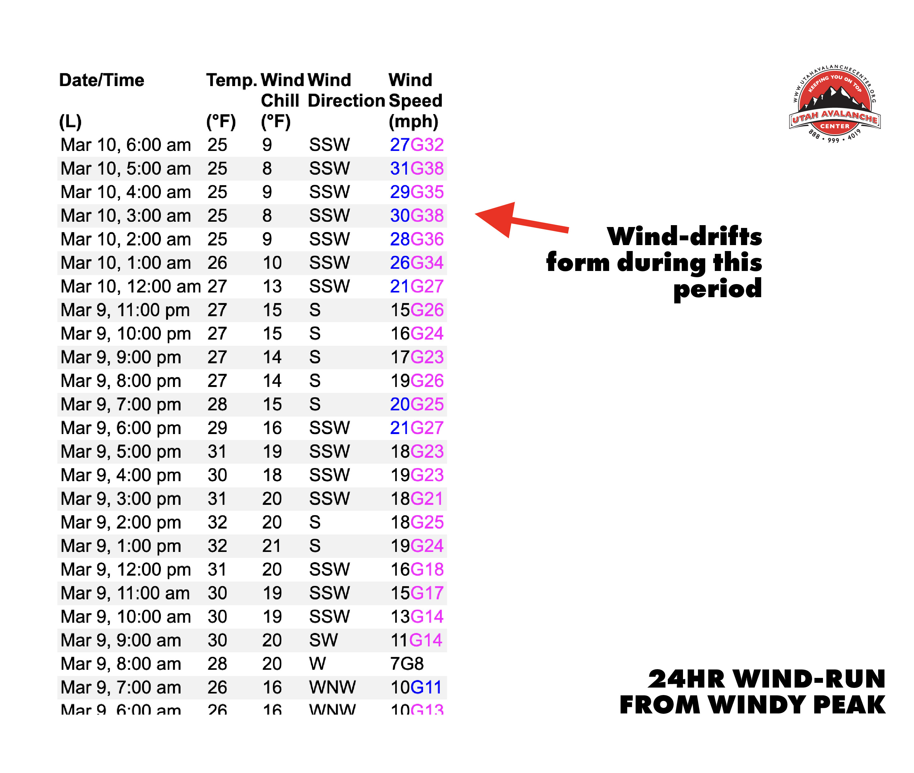
Today, CONSIDERABLE avalanche danger exists on upper elevation slopes facing the north half of the compass, where human-triggered persistent slab avalanches are LIKELY. Additionally, on upper elevation slopes MODERATE danger exists and it POSSIBLE for us to trigger fresh wind-drifts on leeward ridges and slopes with an easterly component.
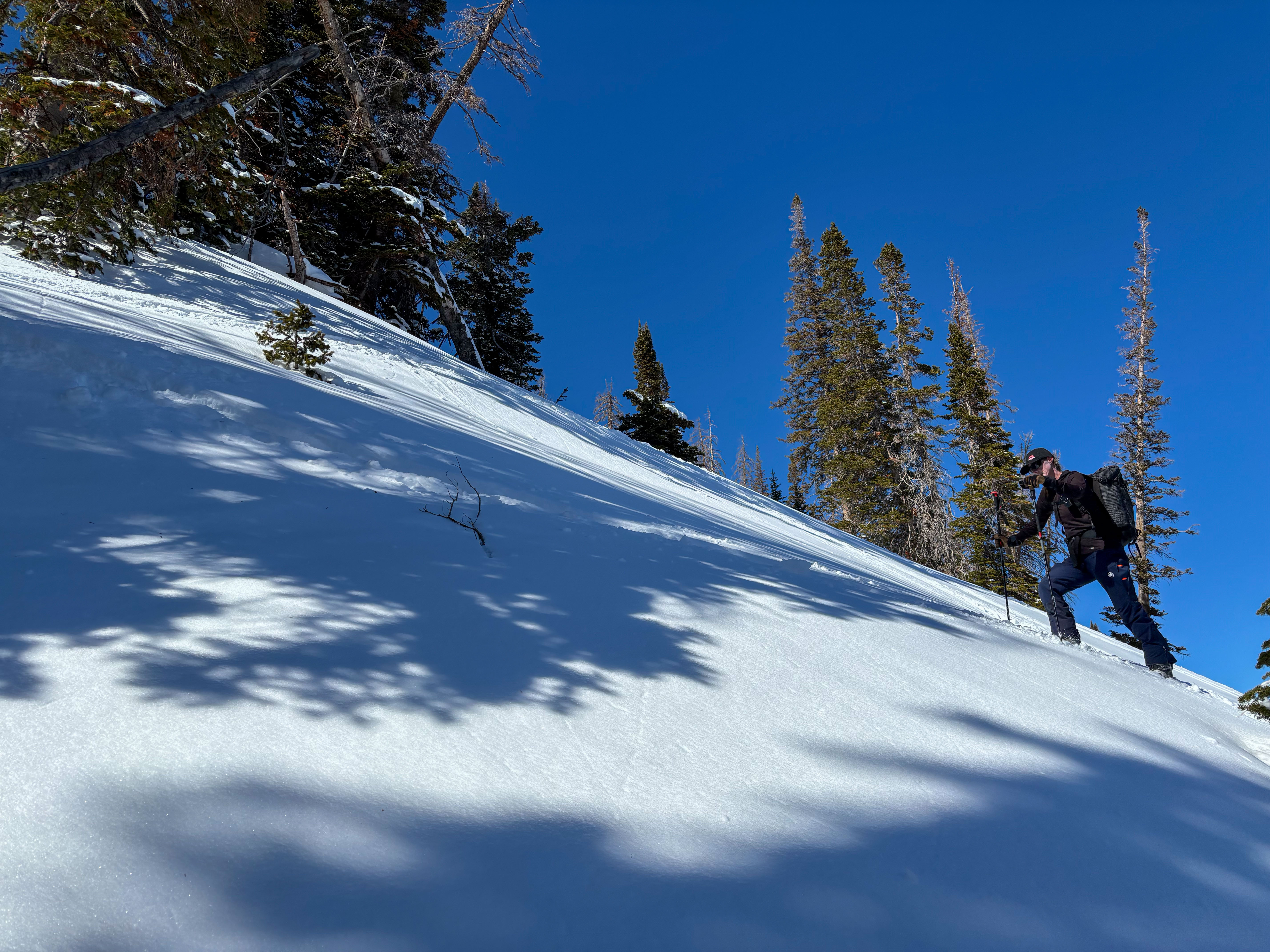
Things feel solid under our feet, but weak snow lingers in the snowpack on shady slopes up high. I am gunning for all the creamy pow I can find on protected, mellower angled slopes while keeping disciplined and steering clear of steep terrain where the persistent weak layers exist.
Low
Moderate
Considerable
High
Extreme
Learn how to read the forecast here
Special Announcements
  • We come to you with heavy hearts and great sadness this morning to confirm an avalanche accident on Friday, March 7th near Hoyt Peak, involving 51 year old Micheal Janulaitis from Marion, Utah. Micheal used a snowbike to access the terrain, but was caught, carried, and killed in an avalanche while skiing a steep, northeast facing run on Hoyt Peak.
    Huge thanks to the Department of Public Safety, Park City Mountain Resort and Canyons Village Snow Safety and Ski Patrol teams, along with Wasatch Backcountry Rescue for the hard work recovering Micheal and returning him to his family. Micheal was a friend of Utah Avy and we feel privileged for the time we got to spend together. This is a tremendous loss for our backcountry family and we will miss him deeply. We are compiling accident details and a preliminary report is available here.
  • Did you know.... March kicks off our Spring Campaign? Well, if everyone in Utah’s backcountry community donates the cost of something they regularly enjoy on an adventure—like a dawn patrol burrito, we could fund not just one but two forecasters for the entire season! More information here.
Weather and Snow
Nowcast This morning clear skies are paired with mild temperatures near 25℉ up to 11k'. Unfortunately, wind chill is in the single digits as southwest winds ramped up hard over night and average wind speeds are clocking in around 30MPH and gusting into the 40's and 50's.
Forecast Looking ahead, today will be another sunny day, but cooler than yesterday with windchill. Expect a high of 30℉ up to 10k' but it will feel much colder with southwest winds backing off slightly, but blowing in the 20's throughout the day up high.
Futurecast High-pressure continues through Wednesday morning, followed by a mid-week storm that looks promising and bring us a solid Uinta refresh for the weekend!
Travel & Riding Conditions
Things heated up significantly over the past few days putting a sun-damper on riding quality for the solar slopes, where hot pow turned unsupportable and breakable at most elevations. Northwest through northeast polar slopes at our highest elevations continue to ride well where cold, protected and recycled powder is hanging around.
The UAC's fearless leader, Paige Pagnucco, joined us for a North Slope field day and found stellar turning conditions in between the sun and the shade on mid and upper-elevation protected slopes.
Recent Avalanches
No avalanche activity has been reported since Friday, March 7th. The last reported avalanche from the range was on Friday where a solo skier triggered a fatal medium-sized persistent slab avalanche and took a ride down a nasty, consequence filled avalanche path. This avalanche was triggered in a thin, steep portion of the slope and failed up to 4' deep on a thin layer of faceted snow. Yes, the likelihood, or chances of triggering an avalanche like this one are going down, but there is still a chance and the consequences remain severe if we do.
Maestro Gordon at the crown of a recent fatal avalanche near Hoyt Peak (10,200') that broke 2-4' deep and 150' wide in a thinner area of the snowpack on an extremely steep, rocky and consequential slope.
Ad
Avalanche Problem #1
Persistent Weak Layer
Type
Location
Likelihood
Size
Description
It feels like spring, but the snowpack has remained thin and sugary in places and the problem is, everything looks white and uniform and feels super solid under our sled, board, or skis. If you trench down, you will still find weak, sugary facets beneath the surface buried between 1 and 3’ deep that are the culprit of recent persistent slab avalanches.
As I begin to turn my feelers onto bigger terrain this spring I am keeping it tight and simply avoiding shallower areas of the snowpack like steep, rocky terrain where I'm more likely to trigger an avalanche into an old persistent weak layer. These shallow areas are between 1 and 3’ deep, and sometimes just pulling out my probe and getting a feel for snow depths is helpful and can help me avoid suspect areas.
If I decide to step out, I make sure the slopes I'm choosing don't have any overhead hazards above me, no consequences in the runout below, and I expose only one person to the slope at a time.
Above, near 11,000' on a northeast slope around Anchor Lake, is an example of a repeater slope... meaning it's avalanched several times and left behind a shallow, weak snowpack. These areas, steep and rocky, are where you are most likely to trigger today's persistent slab avalanche.
Avalanche Problem #2
Wind Drifted Snow
Type
Location
Likelihood
Size
Description
Although things have been baking in the sun on solars. Southwest winds picked up yesterday and they were still finding snow to load onto the easterly facing slopes. Keep an eye out for rounded pillows and stiff. textured drifts near ridges and specific terrain features like couloirs, gullies and chutes.
It’s no joke that 40% of us are killed by trauma in avalanche accidents, meaning we’re dead from slamming into a stump, rock, or tree on the ride down, before we’re even buried by the avalanche we just triggered. As we step out, whether it is into the high-country, or just moving to a bigger slopes, keep in mind the consequences of the terrain you are entering if you do trigger an avalanche and be prepared for the risks you are taking.
Above is a wind-run from Windy Peak at 10, 600', if we know where the wind is blowing, we know here the snow is going and where to look for wind slabs!
Additional Information
From trailhead signs to transceiver training parks, we are always trying to help keep our community styled at the Uinta trailheads. It is no walk on the skin track to keep this signage and equipment up and running all season long. If you see one of our signs in rough shape, or our transceiver parks buried, reach out to us and let us know or feel free to dust off a solar panel and show it a little love. It is a community effort and we couldnt do it without you!
General Announcements
We are always looking for snow and avalanche observations or just general riding conditions. In the meantime reach out to us with questions, concerns, or if you see anything in your travels! Contact us directly through the info below:
This forecast is from the U.S.D.A. Forest Service, which is solely responsible for its content. This forecast describes general avalanche conditions and local variations always occur. This forecast was issued on Monday, March 10th at 05:30 AM and expires 24 hours after it was issued.