March Kicks Off Our Spring Campaign- Donate Now to Support Forecasting

Forecast for the Uintas Area Mountains

Craig Gordon
Issued by Craig Gordon on
Friday morning, February 7, 2020
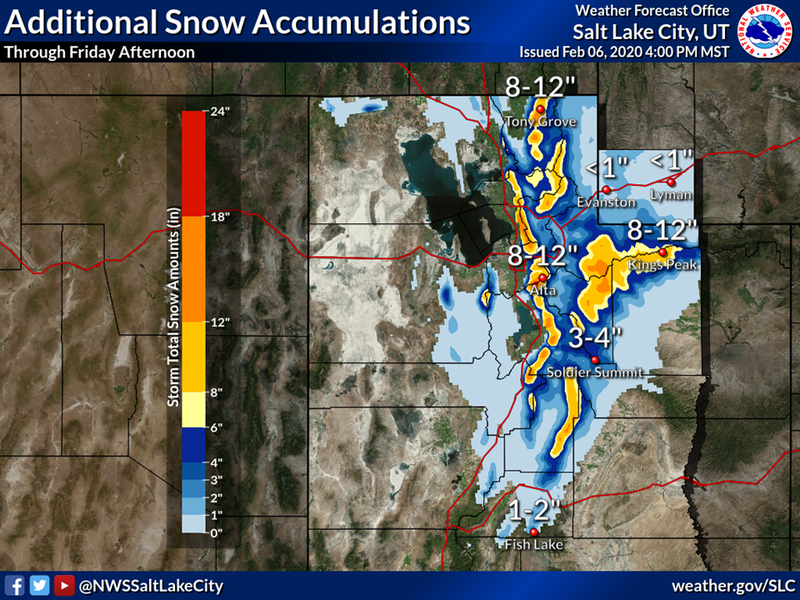
Heads up... unusual weather is producing unusually dangerous avalanche conditions
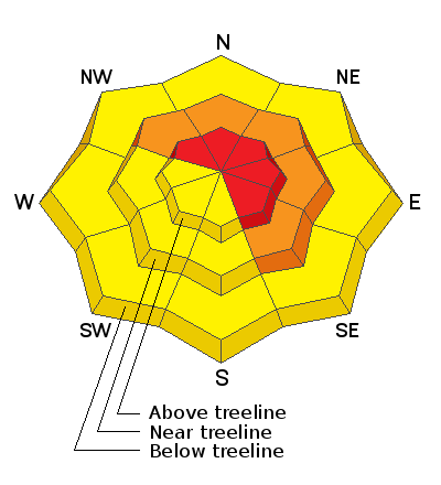
In the wind zone at and above treeline, the avalanche danger is HIGH. Both human triggered and natural avalanches are LIKELY on steep, wind drifted slopes, especially those with an easterly component to its aspect. Avalanches can be triggered from a distance or even low on the slope. While more the exception than the rule, avalanches breaking into deeper, buried weak layers remains a distinct possibility. Usual suspects include- steep, rocky, upper elevation terrain, especially slopes exhibiting a thin, shallow snowpack. Remember- any slide that breaks to old snow, immediately ruins your day.
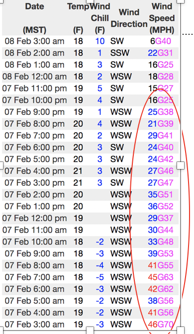
Days of strong, sustained winds drifted snow onto mid elevation terrain where a CONSIDERABLE avalanche danger exists and human triggered avalanches are PROBABLE on steep wind drifted slopes.
A different avalanche dragon lurks at lower elevations where human triggered new snow sluffs are possible on steep slopes and a MODERATE avalanche danger exists.
Low
Moderate
Considerable
High
Extreme
Learn how to read the forecast here
Avalanche Warning
IN EFFECT FROM TO 6 AM MST SATURDAY
FOR THE MOUNTAINS OF NORTHERN UTAH INCLUDING THE WASATCH RANGE...BEAR RIVER RANGE...UINTA MOUNTAINS
THE AVALANCHE DANGER WILL BECOME HIGH ON MANY SLOPES AT DIFFERENT ELEVATIONS AND ASPECTS.
HEAVY DENSE SNOW AND WINDS UP TO 100 MPH HAVE CREATED CREATED WIDESPREAD AREAS OF UNSTABLE SNOW. BOTH HUMAN TRIGGERED AND NATURAL AVALANCHES ARE LIKELY. STAY OFF OF AND OUT FROM UNDER SLOPES STEEPER THAN 30 DEGREES.
Special Announcements
While you're getting ready to ride the North Slope, check out the NEW beacon training park at the Bear River trailhead!
Huge thanks to the very generous donation provided by Dave Allen and of course to Ted Scroggin and Mark Nelson for all the big efforts to install this life saving facility.
Weather and Snow
Currently-
Man.... what a mess! Rain, wind, warm temperatures, rime... oh yeah, and a couple of inches of fresh snow up high, we've got it all. Getting a grip on current weather trends is challenging at best, but what I do know is this... temperatures are elevation dependent with trailheads clocking in near freezing and ridgelines registering in the upper teens. West and southwest winds crank 50-70 mph along the ridges. Snowfall totals are all over the map, but it looks like upper elevation terrain received 8" of snow with an inch of H20 in the past 24 hours. It's super variable out there and most trip reports indicate riding and turning conditions went from hero to zero yesterday.
Uinta weather network info is found here. Simply click on the Western Uinta tab.
For today-
We've got the full meal deal for weather today. Continued very strong ridgetop winds blowing 60- 80 mph, temperatures not straying much from where they're at this morning, and a couple additional inches of snow should stack up.
Futurecast-
A break in the action is expected for Saturday with more stormy weather and colder temperatures finally pushing through the region Saturday night and Sunday.
Recent Avalanches
Very sensitive wind drifts, were reported on steep, leeward slopes yesterday.
To view additional trip reports and recent avalanche activity, simply click here.
Ad
Avalanche Problem #1
Wind Drifted Snow
Type
Location
Likelihood
Size
Description
Follow the wind and you'll find the hazard. Above is a 24 data run from Windy Peak (10,662')
Winds finally relaxed early this morning, but several days of nuking winds, coupled with dense, heavy snow will create upside-down layering with stronger snow resting on top of lighter density snow from last week and of course, that's always a dangerous combination in our mountains. In addition to tricky, trap door riding conditions, I suspect today's fresh drifts can be triggered from a distance and will break deeper and wider than you might expect. The best rule of thumb is to simply avoid steep wind drifted slopes, especially if they look fat and rounded or feel hollow and sound like a drum.
Avalanche Problem #2
Persistent Weak Layer
Type
Location
Likelihood
Size
Description
Right now, most terrain offers a deep snowpack and it's happy in its own skin. However, yesterday's additional dense, heavy snow will test the strength of any weak layers in our pack.
As the storm continues developing I think about suspect terrain I want to avoid and that includes steep, rocky terrain and slopes that avalanched near the ground earlier in the season.
Avalanche Problem #3
New Snow
Type
Location
Likelihood
Size
Description
Heads up... lower elevation terrain we normally consider safe has received a good dose of snow and wind. So, if you're trail running, dog walking, or going out for a family sledding adventure you'll definitely want to avoid being on or underneath steep snow covered slopes and steer clear of terrain traps like gullies or creek bottoms where even a small slide can pile up huge amounts of debris.
In addition, roofalanches are a distinct possibility, especially if you're visiting your cabin for the first time and cranking the heat or building a fire to get it warm inside. In some mountain communities the entire winter snowpack rests on top of steep roofs, they're becoming water laden and prone to avalanching.
Additional Information
Thanks to the generous support of our Utah ski resorts and Ski Utah, we have discount lift tickets available. All proceeds support the UAC. Get your tickets HERE.
Get one of these cool t-shirts to support the UAC and other avalanche centers across the U.S. INFO
General Announcements
The information in this forecast expires in 24 hours, but will be updated by 7:00 AM Sunday Feb. 9th.
This forecast is updated daily by 7:00 AM.
In the mean-time, if you see or trigger an avalanche or just wanna let me know what you're seeing you can reach me directly at 801-231-2170
This is a great time of year to schedule one of our free avy awareness presentations.
You can email me directly [email protected]
The information in this forecast is from the US Forest Service which is solely responsible for its content.