March Kicks Off Our Spring Campaign- Donate Now to Support Forecasting

Forecast for the Uintas Area Mountains

Mark Staples
Issued by Mark Staples on
Friday morning, February 5, 2021
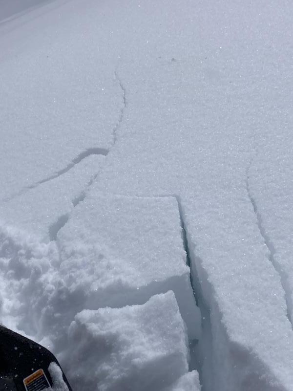
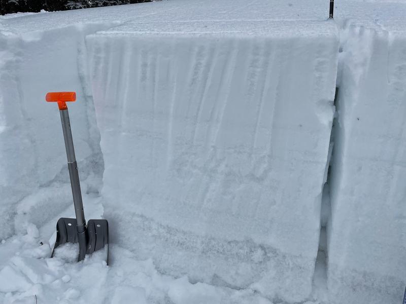
Conditions are already dangerous and today's winds will make it even more dangerous.
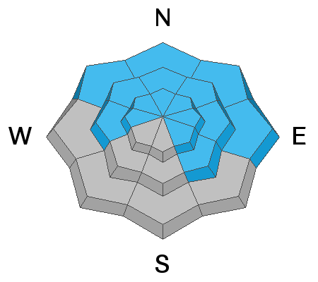
The avalanche danger is CONSIDERABLE on all slopes above treeline and on most slopes near treeline except for south and southwest facing ones.

The danger is MODERATE below treeline. The most likely places for an avalanche below treeline are wind-exposed slopes that have fresh drifts.

Here's your exit strategy- the Uinta's offer plenty of great, low angle terrain options. Simply stick with slopes less than 30 degrees in steepness where avalanches generally don't happen and make sure there's no steep terrain above or adjacent to where you're riding.
Low
Moderate
Considerable
High
Extreme
Learn how to read the forecast here
Special Announcements
In the last six days, there have been 10 avalanche fatalities - 3 skiers in Colorado, 1 skier in Colorado, 3 hikers in Alaska, 1 skier in New Hampshire, 1 skier in California, and 1 in Utah on Square Top.
Yesterday, Craig, Andy, and Joey setup the avalanche beacon training park at the Nobletts trailhead. There is also one at the Bear River Trailhead that Ted Scroggin set up. These beacon parks have pre-buried beacons that you can turn on/off with a control panel. It only takes a few minutes to refresh your beacon searching skills at one of these places.
Weather and Snow
Nowcast-
Yesterday it snowed on and off but never accumulated. This morning temperatures are in the single digits to low teens F. Winds are blowing from the west-northwest 15-20 mph gusting to 30 mph. As for conditions, the snowpack is finally getting some depth with many places having a solid three feet of snow on the ground and a few places at upper elevations with close to four feet.
Forecast-
Today will be cold, snowy, and windy. Snow will begin falling this morning with 4-8 inches by the end of the day and a few more inches tonight. Total snow by tomorrow morning could be 6-12 inches of low density powder (0.5-0.7 inches of water). Temperatures today should reach the mid to upper teens F. Winds will steadily increase through the day from the west-northwest easily blowing 40 mph with gusts that may reach 50-60 mph.
Futurecast-
Cold and windy conditions will continue into Sunday with a mix of clouds and sun and generally dry weather into the start of next week.

Looking for real-time temps, snow, or wind?
Click here and then on the "western Uinta" tab for western Uinta specific, weather station network.
Recent Avalanches
There was one small avalanche spotted yesterday in the Soapstone area. A much larger intentionally triggered avalanche happened Wednesday in upper Weber Canyon that was a 3 foot thick hard slab over a wide area. On Monday in upper Moffit Basin, there was a human triggered slide 2-4 feet deep and 150 feet wide.
There are five great obs from yesterday worth reading. Craig was in Mill Hollow, I was in Moffit Basin, JG was in upper Weber Canyon, Ted was near Gold Hill, and M. Davis was in Soapstone. Find them here.
Cracking of the snowpack is a clear sign of unstable conditions
Ad
Avalanche Problem #1
Persistent Weak Layer
Type
Location
Likelihood
Size
Description
Persistent weak layers (PWL) of faceted snow continue to plague the snowpack. The two primary weak layers are one from late Nov/early Dec near the ground, and one from early January in the middle of the snowpack or slightly higher.
The slab on top of these PWLs has been getting thicker and denser as a result of recent snowfall, recent wind and recent warm temperatures. Imagine a building with a weak foundation but we keep adding additional floors on top - eventually the whole structure will collapse. Every slope has the weak foundation. What is different is how many floors are on top of it.
The result of this dense slab is that avalanches are getting bigger both in depth and area. Expect avalanches that can be hundreds of feet wide and 2-3 feet deep.
  • Above and near treeline this avalanche problem is widespread.
  • Below treeline, the weak layer is widespread but the distribution of the slab on top is more pockety and a little dependent on where winds drifted snow and helped create a more cohesive slab.
What's tricky - the first person to ride on or even near a slope may not trigger it. Instead, it may be the 2nd, 3rd, or even 10th person on a slope who triggers it. Seeing tracks on slope doesn't mean it's safe.
Craig describes this set up in the video below
Photo below from an east facing slope shows that weak, rotten foundation in the snowpack near the ground. All the snow above it is what will avalanche.
Avalanche Problem #2
Wind Drifted Snow
Type
Location
Likelihood
Size
Description
Winds have blown from many different directions. Strong southwest winds blew earlier this week. Prior to that there were some strong southeast winds. Mixed in here and there have been the regular west winds, and today winds will come from the northwest.
The main issue with slabs of wind drifted snow is that they increase the load and stress on buried persistent weak layers described above which increases the likelihood of triggering a slide. Avalanches may start in these wind slabs but then step down into deeper layers in the snowpack and break of large areas hundreds of feet across.
What's tricky - winds coming from different directions plus snowfall today will make it hard to identify deposits wind drifted snow.
Additional Information
I will update this forecast by 7:00 AM tomorrow, Saturday, February 6th.
Your observations are import, so please let me know what you're seeing... click HERE and contribute to this amazing community based program
General Announcements
If you see or trigger an avalanche or just wanna let me know what you're seeing you can reach me directly at 801-231-2170 or [email protected]
This forecast is from the U.S.D.A. Forest Service, which is solely responsible for its content. This forecast describes general avalanche conditions and local variations always occur.