March Kicks Off Our Spring Campaign- Donate Now to Support Forecasting

Forecast for the Uintas Area Mountains

Craig Gordon
Issued by Craig Gordon on
Tuesday morning, February 25, 2020
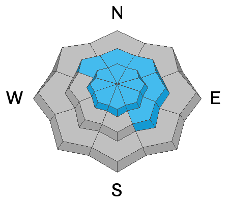
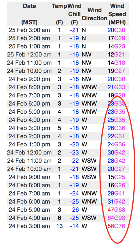
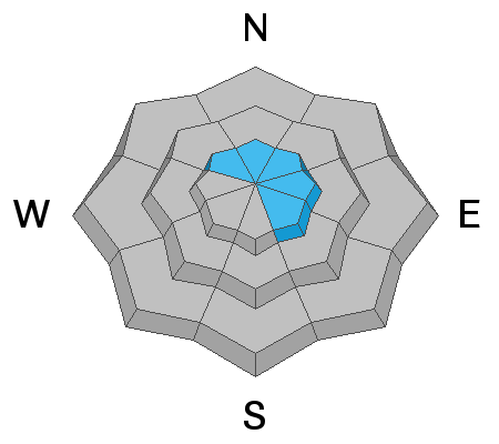
In the wind zone, at and above treeline, a few lingering wind drifts are found on steep, leeward slopes. Not particularly widespread, but large enough to knock you off your feet you'll find both soft and hard, dense slabs reactive to our additional weight and pockets of MODERATE avalanche danger exist. Making up a small portion of the terrain available to ride today, human triggered avalanches are POSSIBLE, especially on slopes with an easterly component to its aspect. In addition... while more the exception than the rule, avalanches breaking into deeper, buried weak layers are still possible. Usual suspect terrain includes- steep, rocky, upper elevation terrain, especially slopes exhibiting a thin, shallow snowpack and this includes repeater avalanche paths. Remember- any slide that breaks to old snow, instantly throws a curve ball at your day.
Wind sheltered mid and low elevation terrain offers generally LOW avalanche danger.
Low
Moderate
Considerable
High
Extreme
Learn how to read the forecast here
Special Announcements
The UAC's Avy Awareness Auction is currently underway with tons of great gear, jewelry, artwork and experiences available. Visit the auction page here to help support the UAC's spring avalanche awareness and outreach efforts.
Click here for more details.
And... a new version of the UAC IOS application is now available on the Apple App Store. This version fixes many of the issues that occur when running IOS 13.
Click here for more details.
Weather and Snow
Currently-
Yesterday's cow tipping winds, quickly calmed down right after sunrise and a quick hitting storm delivered 3" of light density snow across the range. (Note.... no cows were injured during the making of the small storm or this forecast :) Under clear skies, it's cold, with temperatures registering near zero degrees. Along the ridges northerly winds blow in the 20's and 30's and windchill factors clock in at -22 degrees. Recent winds blasted our high alpine terrain, but on a go-anywhere base, if you seek out mid elevation, wind sheltered slopes, and you'll be rewarded with shallow, creamy snow.
Uinta weather network info is found here. Simply click on the Western Uinta tab.
For today-
High pressure builds over the mountains today and tonight bringing quiet weather and decreasing winds. Look for mostly sunny skies with high temperatures cracking into the low 20's.
Futurecast-
Quiet weather is expected to continue through the rest of the work week, with a bump in winds on Wednesday as a weak weather disturbance slides to our northeast.
Recent Avalanches
No significant avalanche activity to report.
To view additional trip reports and recent avalanche activity, simply click here.
Ad
Avalanche Problem #1
Wind Drifted Snow
Type
Location
Likelihood
Size
Description
Follow the wind and you'll find the avalanche.... above yesterday's data run from Windy Peak (10,662') clearly illustrating wind speed, direction, and duration of yesterday's wind event.
Yesterday's strong westerly winds coupled with a few inches of light density snow created sensitive drifts, forming much lower down-slope than we usually expect to see. While I think the majority of these day old drifts have settled out, I always need to remind myself the Uinta's are a huge range and I bet there's a lingering wind slab or two that'll react to our additional weight. Most prevalent on the leeward side of mid and upper elevation ridges, be on the lookout for older drifts cross-loaded around terrain features like chutes and gullies. Climbing is easy right now and if you're tagging steep, technical terrain, remember that even a small slide could knock you off your feet and boss you around. So, the ticket to riding safely today is simply look for and avoid any fat, rounded piece of snow, especially if it sounds hollow like a drum.
Avalanche Problem #2
Persistent Weak Layer
Type
Location
Likelihood
Size
Description
It's been several days since I've heard of any avalanches breaking to older layers in the snowpack and that's good news. However, snow is a curious medium and all we need to do is find one inconsistency or a shallow zone, maybe around a rock or bush, collapse the pack, and now we've got a bigger slide than we might've bargained for. So my safe travel strategy is to think about suspect terrain I want to continue avoiding and that includes steep, rocky terrain and slopes that avalanched near the ground earlier in the season.
Additional Information
Andy found good riding in shallow, creamy pow Sunday on the south half of the range. A most excellent trip report is found here.
It's been a great winter and the coverage even at lower elevations is quite good. High fives to the crew laying down the old school eights near the mouth of Weber Canyon.
General Announcements
The information in this forecast expires in 24 hours, but will be updated by 7:00 AM Wednesday Feb. 26th.
This forecast is updated daily by 7:00 AM.
In the mean-time, if you see or trigger an avalanche or just wanna let me know what you're seeing you can reach me directly at 801-231-2170
This is a great time of year to schedule one of our free avy awareness presentations.
You can email me directly [email protected]
The information in this forecast is from the US Forest Service which is solely responsible for its content.