March Kicks Off Our Spring Campaign- Donate Now to Support Forecasting

Forecast for the Uintas Area Mountains

Craig Gordon
Issued by Craig Gordon on
Monday morning, February 22, 2021
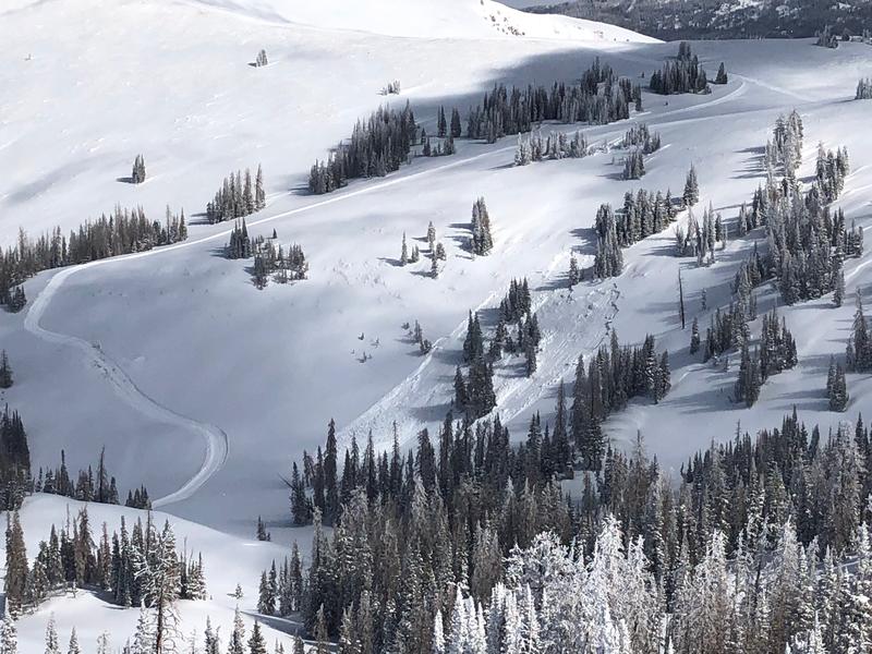
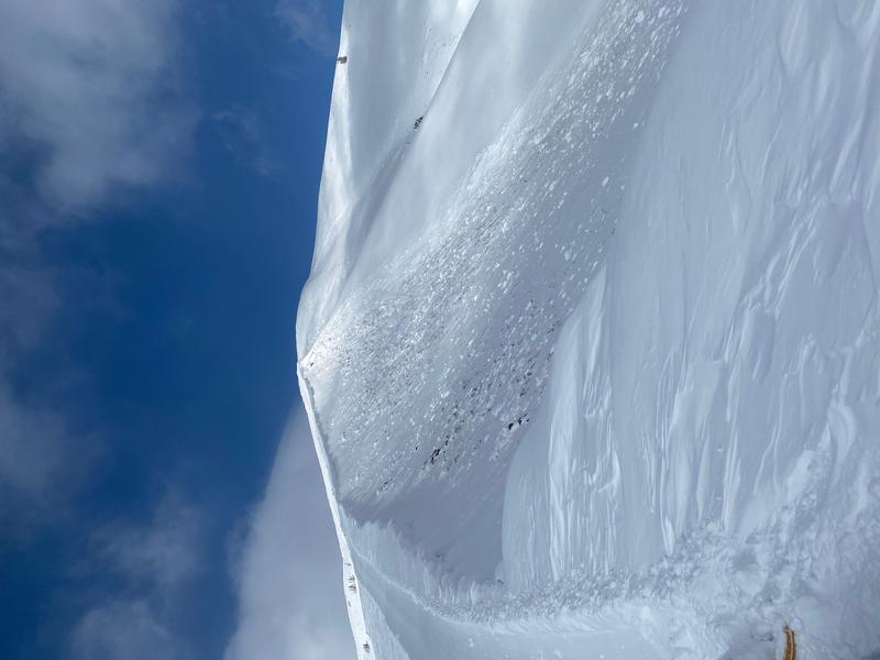
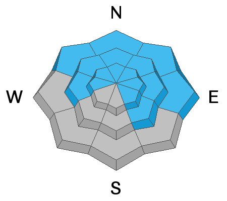
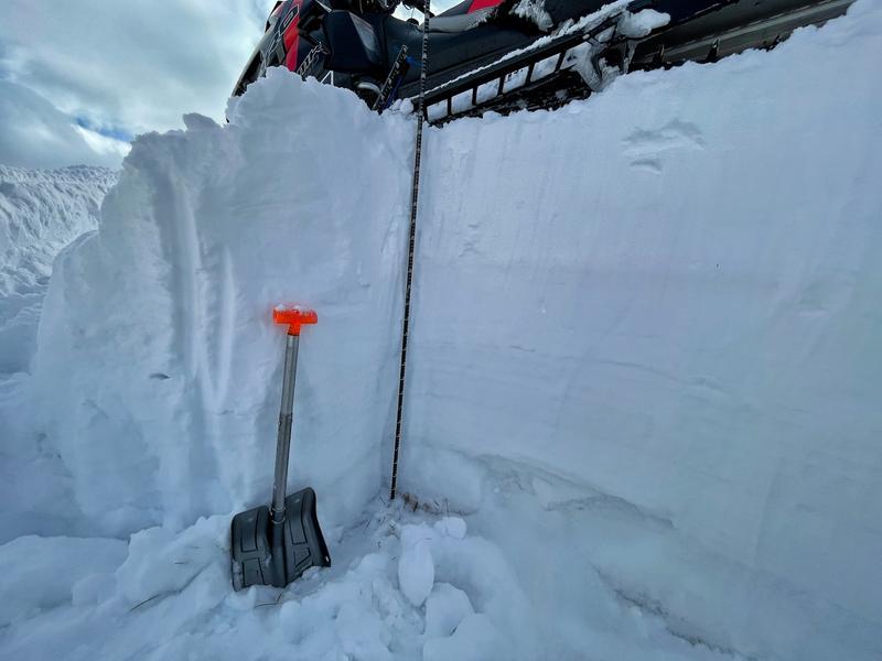
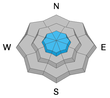
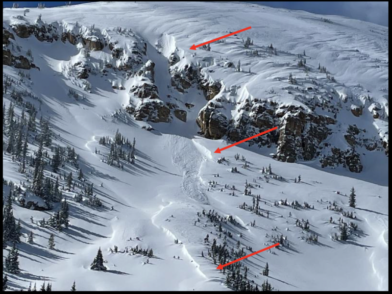
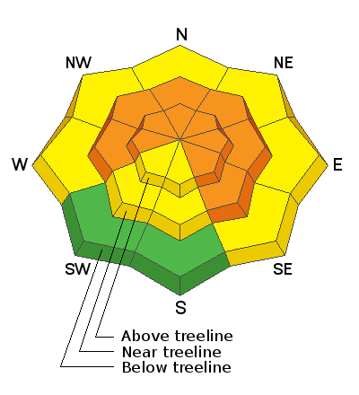
Today, near and above treeline, the avalanche danger is CONSIDERABLE and HUMAN TRIGGERED AVALANCHES ARE LIKELY, especially on steep slopes facing west, through north, through southeast. Once triggered, today's avalanches can fail near the ground, breaking 2-5 feet deep and hundreds of feet wide.

All other terrain below treeline offers MODERATE avalanche danger. Remember- many of these areas have a slab of snow resting on weak facets. And while the odds of triggering a slide have decreased somewhat, human triggered avalanches remain possible.

Riding conditions are excellent on low angle slopes and you can tag lower elevation south facing terrain before any glancing blow from the sun takes its toll. Take advantage of the many areas of gentle, rolling terrain that isn't steep enough to produce avalanches, but make sure to avoid being under slopes steeper than 30 degrees.
Low
Moderate
Considerable
High
Extreme
Learn how to read the forecast here
Weather and Snow
Nowcast-
High clouds cast filtered moonlight on our mountains this morning, creating a stunning silhouette. It'll feel like late winter as you step out into the world with temperatures registering in the low to mid teens. Along the high peaks, northwest winds blow in the 20's, creating a windchill that clocks in at -8 degrees. Riding and turning conditions are all-time as storm totals since last Friday clock in at nearly 2' of snow with just over 2" of water... just slightly above our average snow densities. (Scroll to the bottom of the page to see two graphs showing snowfall since last Friday). The Uintas are white with total settled snow depths averaging right around 5'.
Forecast-
A beautiful day is on tap as high pressure builds over the region, delivering partly cloudy skies with northwesterly winds blowing into the 20's along the peaks. High temperatures climb into the upper 20's with overnight lows dipping into the teens.
Futurecast-
A mid week brush-by produces cooler temperatures and a few scattered snow showers. While it's a little too early in the forecast period to nail down timing and strength, a stronger system is slated to round out the work week.

Looking for real-time temps, snow, or wind?
Click here and then on the "western Uinta" tab for western Uinta specific, weather station network.
Recent Avalanches
Both avalanches in the images above were remotely triggered in steep, upper elevation terrain, by a snowcat working in the area. While they illustrate different dimensions, the big take home is this- both pieces of snow broke deep and wide, failing on weak snow near the ground, and they were triggered from a distance... meaning you don't have to be on the slope, you simply need to be connected to it! HEADS UP... THIS IS A MAJOR RED FLAG

More obs, trip reports, and avalanches found here.
Ad
Avalanche Problem #1
Persistent Weak Layer
Type
Location
Likelihood
Size
Description
My partner and I traveled into mid elevation terrain Saturday and we were stoked to see how the snowpack has grown in depth and how well it's becoming comfortable in its own skin.
For an avalanche forecaster, watching the snowpack develop is like watching your child grow. Fortunately, I think we're starting to get out of the teenage years where you just look at the snowpack and it gets riled, but I still think there's enough uncertainty to warrant continued caution before handing over the keys to the car and turning our backs. While snow stability tests and overall snowpack depths are encouraging, the biggest clue to avalanches is avalanches, and recent avalanche activity illustrates the tricky nature of this setup.
The good news is... the Uinta snowpack has gotten a lot deeper after last weekend's series of storms. The bad news is... recent snowfall made the slab much thicker and more dangerous. In places where the slab is thickest, avalanches are harder to trigger because it is harder to impact weak snow near the ground. However, thin spots, like around rocks or bushes, are often good trigger points and all we need to do is collapse the slope, trigger the slide, and now the entire seasons snowpack is crashing down on us. Mark was in Lakes Country yesterday and has a great observation along with some advice on how to travel safely given these conditions posted HERE.
The photo below shows weak snow near the ground, and how a snowmobile can stay on top of the snowpack. However, there are a lot of different ways for a sled or a skier to impact the weak layer. Because the snowpack is not the same depth across a slope, it's easy to hit a thin spot and trigger an avalanche. Tracks on a slope DO NOT mean it is stable.
And more travel advice from Ted Scroggin... a savvy, avy pro who knows the Uinta Mountains better than anyone. He offers these sage words... "To me, these are tricky conditions, there were some natural avalanches, some slopes have filled back in, and things look and feel good to go. Normally this time of year we are starting to venture out more on bigger slopes, but the current snowpack is still not to be trusted even though conditions feel great under our sleds and skis."
Avalanche Problem #2
Wind Drifted Snow
Type
Location
Likelihood
Size
Description
Mark captured this viddy yesterday, showing winds moving a fair bit of snow around near the high peaks.
Near the high ridges, recent winds, formed dense slabs on the leeward side of upper elevation ridges and around terrain features like chutes and gullies. Problem is... older drifts are covered over with fresh snow, making them hard to detect. And remember- wind slabs add additional stress to buried persistent weak layers keeping them on edge and ready to fracture and produce an avalanche. So today, today you'll want to look for and avoid any fat, rounded piece of snow, especially if it feels hollow like a drum.
Recent winds, blowing right to left in the images above, illustrate cross-loading around chutes and gully features.
Additional Information
Total snow depth graph from the Camp Steiner weather station for Friday, Feb 12 to Thursday, Feb 18.
Total snow depth and snow water equivalent from the Trial Lake SNOTEL site for Friday, Feb 12 to Thursday, Feb 18.
I will update this forecast by 7:00 AM tomorrow, Tuesday, February 23rd.
Your observations are important, so please let me know what you're seeing... click HERE and contribute to this amazing community based program
General Announcements
If you see or trigger an avalanche or just wanna let me know what you're seeing you can reach me directly at 801-231-2170 or [email protected]
This forecast is from the U.S.D.A. Forest Service, which is solely responsible for its content. This forecast describes general avalanche conditions and local variations always occur.