March Kicks Off Our Spring Campaign- Donate Now to Support Forecasting

Forecast for the Uintas Area Mountains

Mark Staples
Issued by Mark Staples on
Saturday morning, February 20, 2021
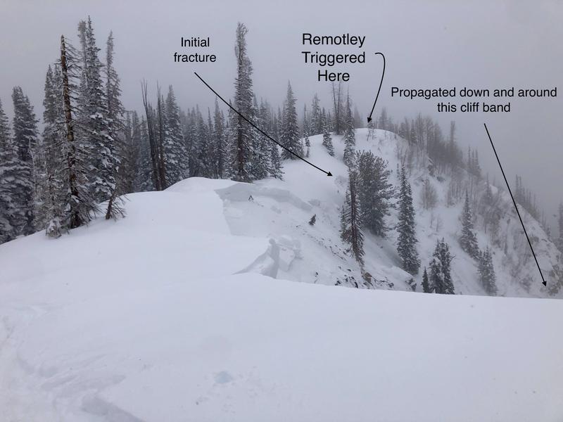
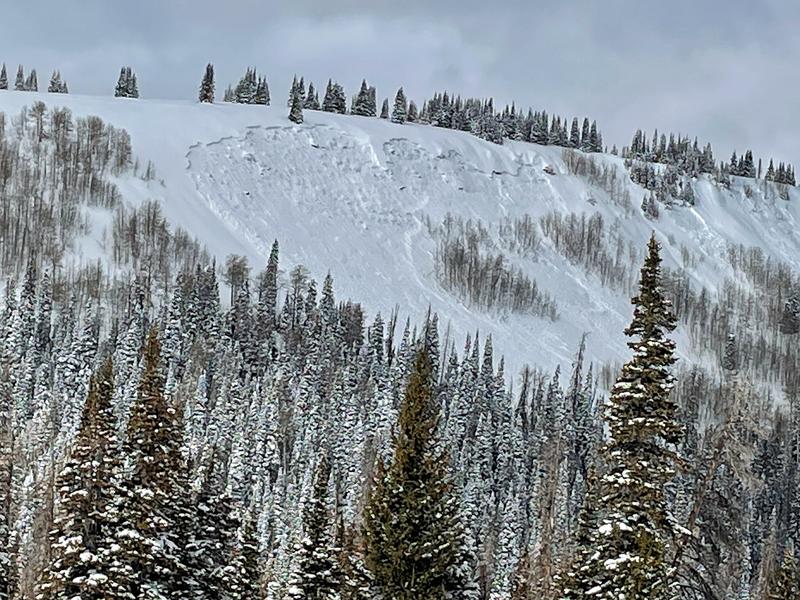
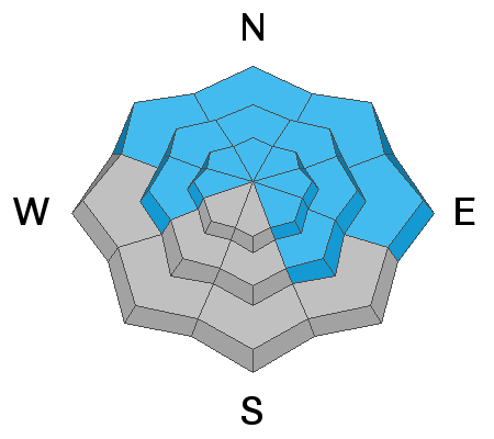
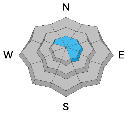
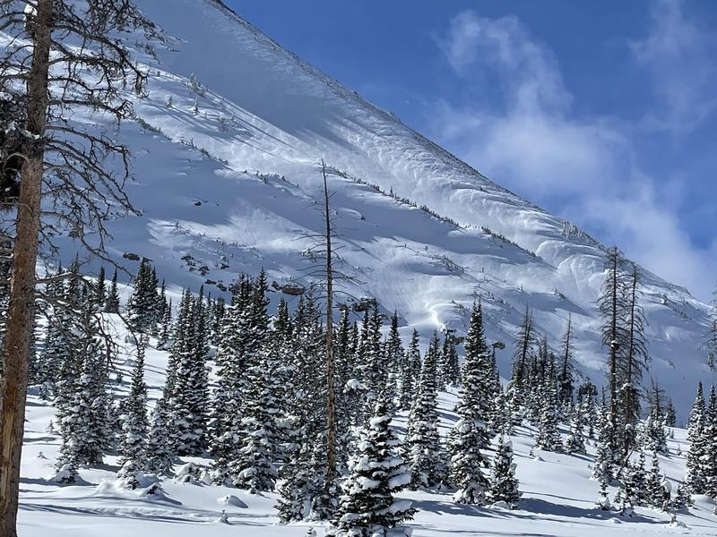
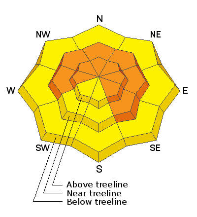
Today HUMAN TRIGGERED AVALANCHES ARE LIKELY and the avalanche danger is CONSIDERABLE near and above treeline in terrain facing west, north, east and southeast. Avalanches will be 2-5 feet deep and hundreds of feet wide.

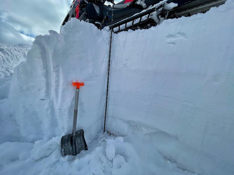
All other terrain below treeline as well as terrain facing south and southwest facing has a MODERATE danger. Many of these areas also have a slab of snow resting on weak facets but the odds of triggering a slide have gone down and human triggered avalanches remain possible.

Riding conditions are excellent. Take advantage of the many areas of gentle, rolling terrain that isn't steep enough to produce avalanches, but make sure to avoid being under slopes steeper than 30 degrees.
Low
Moderate
Considerable
High
Extreme
Learn how to read the forecast here
Weather and Snow
Nowcast-
Yesterday morning 1-2 inches of snow fell. This morning, temperatures are in the upper teens and low 20s F while at most trailheads they are near 30 degrees F. Winds on the high peaks are blowing from the southwest 20-30 mph and gusting 40-50 mph. Winds at lower ridgelines are averaging 10 mph gusting to 15 mph.
Forecast-
About 2-4 inches of snow will fall today under cloudy skies. Winds will shift to the northwest and ease, and then temperatures will start dropping this afternoon. By late afternoon, temperatures will be in the low teens F.
Futurecast-
Temperatures will drop into the single digits F tonight. Sunday will remain cold but there will be a mix of clouds and sunshine. No major storms are expected but a little snow could fall Tues/Wed with a short lived warm-up followed by more cold temperatures in the latter half of next week. Then more snow could come next Fri/Sat, but that's too far ahead to know with much certainty. The main point is that there are several chances for snow next week and there is no major ridge of high pressure expected.
Snowfall totals since last Friday are generally 20-24 inches of snow (2-2.4 inches of water). Total snow depths range from 3.5 to 6 feet. Scroll to the bottom of the page to see two graphs showing snowfall since last Friday.

Looking for real-time temps, snow, or wind?
Click here and then on the "western Uinta" tab for western Uinta specific, weather station network.
Recent Avalanches
Yesterday, John G. was near the south fork of the Weber River and remotely triggered an avalanche 2 feet deep and about 1000 feet wide on an east aspect near 10,000 feet. THIS IS A MAJOR RED FLAG. A remotely triggered avalanche means that it was triggered by them just walking near the slope but not being on it.
Yesterday a little further south in Mill Hollow, I spotted another recent avalanche that was only a day or two old. It was about 2 feet deep and over 1000 feet wide on an east facing slope near 9700 feet. It was most likely naturally triggered by gentle wind loading (notice that the trees near the top of the avalanche still have snow on them). Winds had been gently drifting small amounts of snow onto this slope. There were some snowmobile tracks nearby that could have remotely triggered this slide. Either way, natural or remotely triggered, it's another major red flag.

More obs, trip reports, and avalanches found here.
Ad
Avalanche Problem #1
Persistent Weak Layer
Type
Location
Likelihood
Size
Description
The most dangerous and likely problem is large slab avalanches breaking on persistent weak layers near the ground. On Thursday along the Mirror Lake highway, I triggered cracks shooting 100 feet in front of my sled which told me if I had been on a steeper slope, I would have triggered an avalanche (observation, video)
The good news is that the snowpack in the Uinta Mountains has gotten a lot deeper after last weekend's series of storms. The bad news is that snowfall made the slab much thicker and more dangerous. In places where the slab is thickest, avalanches will be harder to trigger because it is harder to impact weak snow near the ground. However, thin spots or rocky areas are often good trigger spots.
A scary combination exists on slopes loaded by recent winds near the top but with a thinner snowpack near the bottom of the slope where an avalanche can be triggered.
The photo below shows weak snow near the ground, and how a snowmobile can stay on top of the snowpack. However, there are a lot of different ways for a sled or a skier to impact the weak layer. Because the snowpack is not the same depth across a slope, it's easy to hit a thin spot and trigger an avalanche. Tracks on a slope DO NOT mean it is stable.
Ted Scroggin who knows the Uinta Mountains better than anyone added these words of wisdom: "To me, these are tricky conditions, there were some natural avalanches, some slopes have filled back in, and things look and feel good to go. Normally this time of year we are starting to venture out more on bigger slopes, but the current snowpack is still not to be trusted even though conditions feel great under our sleds and skis."
Avalanche Problem #2
Wind Drifted Snow
Type
Location
Likelihood
Size
Description
Strong southwest winds blew yesterday and this morning mostly at the highest elevations forming hard slabs of wind drifted snow. Earlier last week they blew from the northwest. Overall, winds seem to have mainly affected the high peaks and done minimal drifting below treeline.
These wind slabs add additional stress to buried persistent weak layers keeping them stressed and ready to fracture and produce an avalanche.
The photo below from Bald Mountain shows obvious drifting on the peak but trees in the foreground were untouched by wind and are still snow-covered.
Additional Information
Total snow depth graph from the Camp Steiner weather station for Friday, Feb 12 to Thursday, Feb 18.
Total snow depth and snow water equivalent from the Trial Lake SNOTEL site for Friday, Feb 12 to Thursday, Feb 18.
We will update this forecast by 7:00 AM tomorrow, Sunday, February 21st.
Your observations are important, so please let me know what you're seeing... click HERE and contribute to this amazing community based program
General Announcements
If you see or trigger an avalanche or just wanna let me know what you're seeing you can reach me directly at 801-231-2170 or [email protected]
This forecast is from the U.S.D.A. Forest Service, which is solely responsible for its content. This forecast describes general avalanche conditions and local variations always occur.