Forecast for the Uintas Area Mountains

Craig Gordon
Issued by Craig Gordon on
Tuesday morning, February 17, 2026

Heads up.... avalanche danger is getting real and it's time to pump the brakes and rein it in-

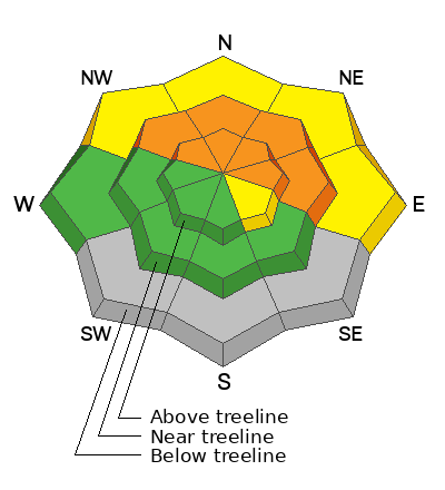
For today, CONSIDERABLE avalanche danger exists at and above treeline, especially in the windzone, and particularly on steep slopes facing the north half of the compass. Both human triggered and natural avalanches are LIKELY. It's getting tricky out there and it ain't straight-forward. In fact, this is the setup when we begin seeing close calls and near misses as the snowpack teeters on the edge, is unpredictable, and we're able to remotely trigger avalanches from a distance.

As the storm continues churning away, I'm steering clear of upper elevation slopes and setting my sights on wind sheltered terrain free of any overhead hazard.

Low
Moderate
Considerable
High
Extreme
Learn how to read the forecast here
Avalanche Watch
An Avalanche Watch is in effect from Tuesday, 2/17/26 at 6:00 AM MST through 6:00 AM MST Wednesday, 2/18/26.

What: Heavy snowfall and strong winds are increasing avalanche danger across the mountains of Northern and Central Utah, as well as Southwestern Utah and Southeast Idaho. Forecasters at the Utah Avalanche Center expect dangerous, complex avalanche conditions to develop on many slopes this week, with large natural and human-triggered avalanches likely.

Where:
The Avalanche Watch is for the mountains of Northern, Central, and Southwestern Utah, as well as Southeastern Idaho.

Impacts:

  • Dangerous avalanche conditions are expected to develop on many slopes.

  • Avalanches can be triggered on slopes steeper than 30 degrees. They may also be triggered remotely (from a distance) or from below.

What to do:

  • Avoid traveling on or underneath steep terrain at mid and upper elevations in the backcountry.

  • Carry and know how to use avalanche rescue equipment, including a transceiver, shovel, and probe.

  • Find safer riding conditions on slopes less than 30 degrees with no overhead hazard.

Weather and Snow

Nowcast - Is it always this breezy in these parts? Yup... the zone that invented wind, shifts from patent pending, directly into trademark realm. Winds from the south, blowing 40-60 mph, pepper the ridges and punish the high peaks with gusts near 90 mph. It's mostly blow with little snow, but since the turn of the new day, I think we were able to stack up 3" of medium density snow across the range. Trial Lake clocks in with 5" snow and .40" H2O... over-achiever. Cooler air is just beginning to filter into the region and temperatures hover in the high teens °F.

Forecast - Look for mostly cloudy skies and another couple inches of dense snow piling up through the morning commute. Winds shift to the west early this morning and should decrease from cow-tipping to obnoxious, yet still blow in the 40-50 mph range near the ridges. Temperatures climb into the upper 20's °F and dip into the teens °F overnight.

Futurecast - And the hits just keep coming! Looks like a better shot of snow materializes for Wednesday morning, continuing through most of the day, producing the kind of snow that makes our license plates famous :)

Travel Conditions - After about a month without significant snowfall, finally, the Uinta's got a decent refresh last week and again overnight . At lower elevation trailheads, especially on solar aspects, the vibe feels late spring. But turn the corner towards polar slopes, gain some elevation, and it's looking more winter-esque. The snowpack, in general ranges from 1-4' deep, and is mostly right side up in protected, sheltered terrain providing quality travel and riding. At upper elevations in the windzone, this weeks storm snow rests on a variety of surfaces from old drifts, to rocks, to sugary faceted snow. Warm temperatures over the past few days and strong solar input have turned most sunny slopes crusty, while shady slopes continue to offer soft, settled, cold snow. Over the weekend, Andy and Kyle had a big day around the Mirror Lake Corridor, finding quality travel and stellar riding on the north half of the compass above 9,000'.
Recent Avalanches

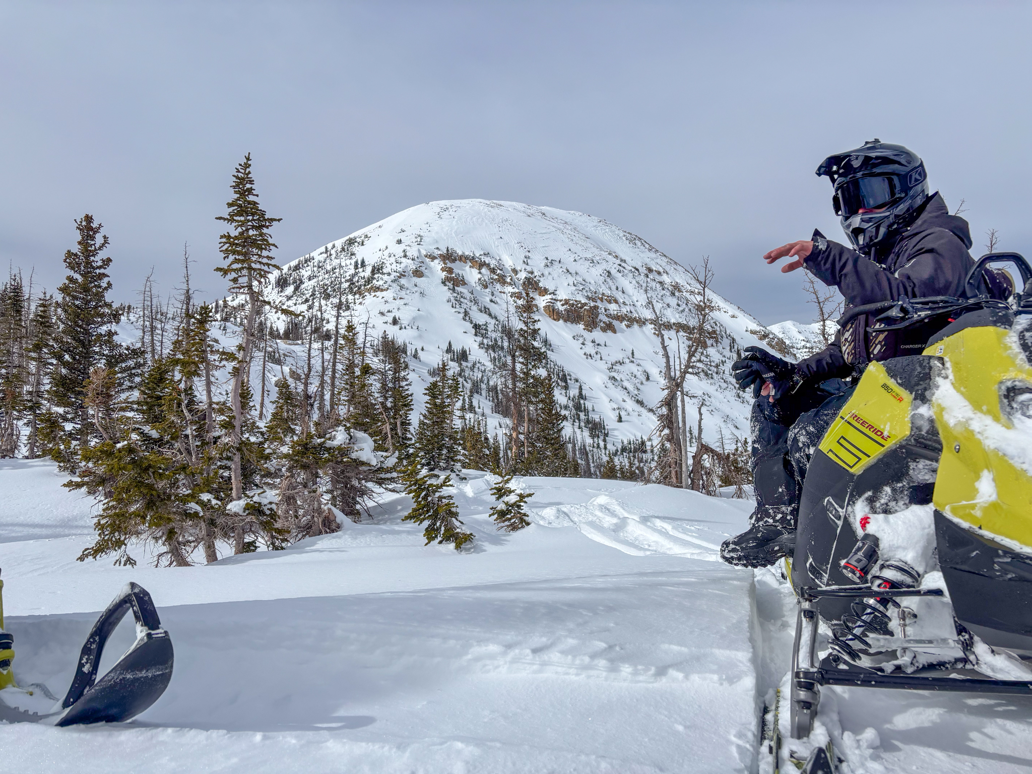
Yesterday, a very experienced big mountain crew got to witness Reid's Peak roaring to life late in the day. A great first hand account is found HERE.


Avalanche Problem #1
Wind Drifted Snow
Type
Location
Likelihood
Size
Description

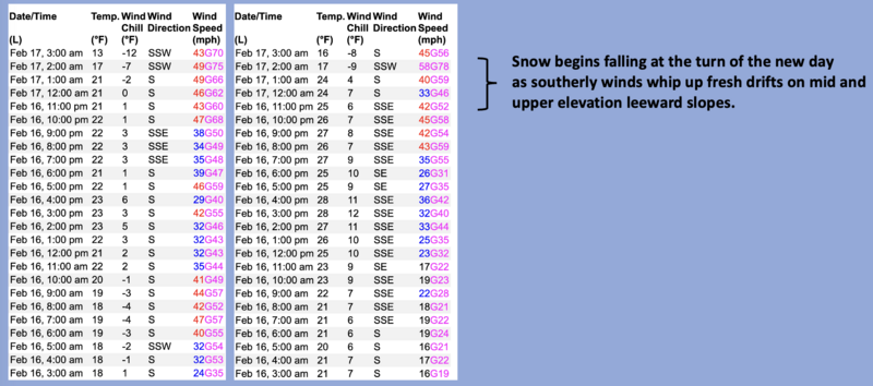
Above is a 24 hour data dump for Lofty Lake Peak (11,186') and Duchesne Ridge (10,154') illustrating wind penetrating into usually wind sheltered terrain.

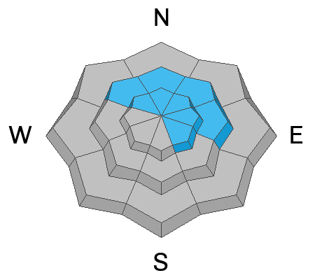
Winds have raged for nearly two days and now finally, they have some storm snow to work with. Found on the leeward side of ridges and lower downslope than we might expect, fresh drifts connect the dots on the north half of the compass. Once triggered, today's drifts are big enough to let us know who's the boss.

Avalanche Problem #2
Persistent Weak Layer
Type
Location
Likelihood
Size
Description

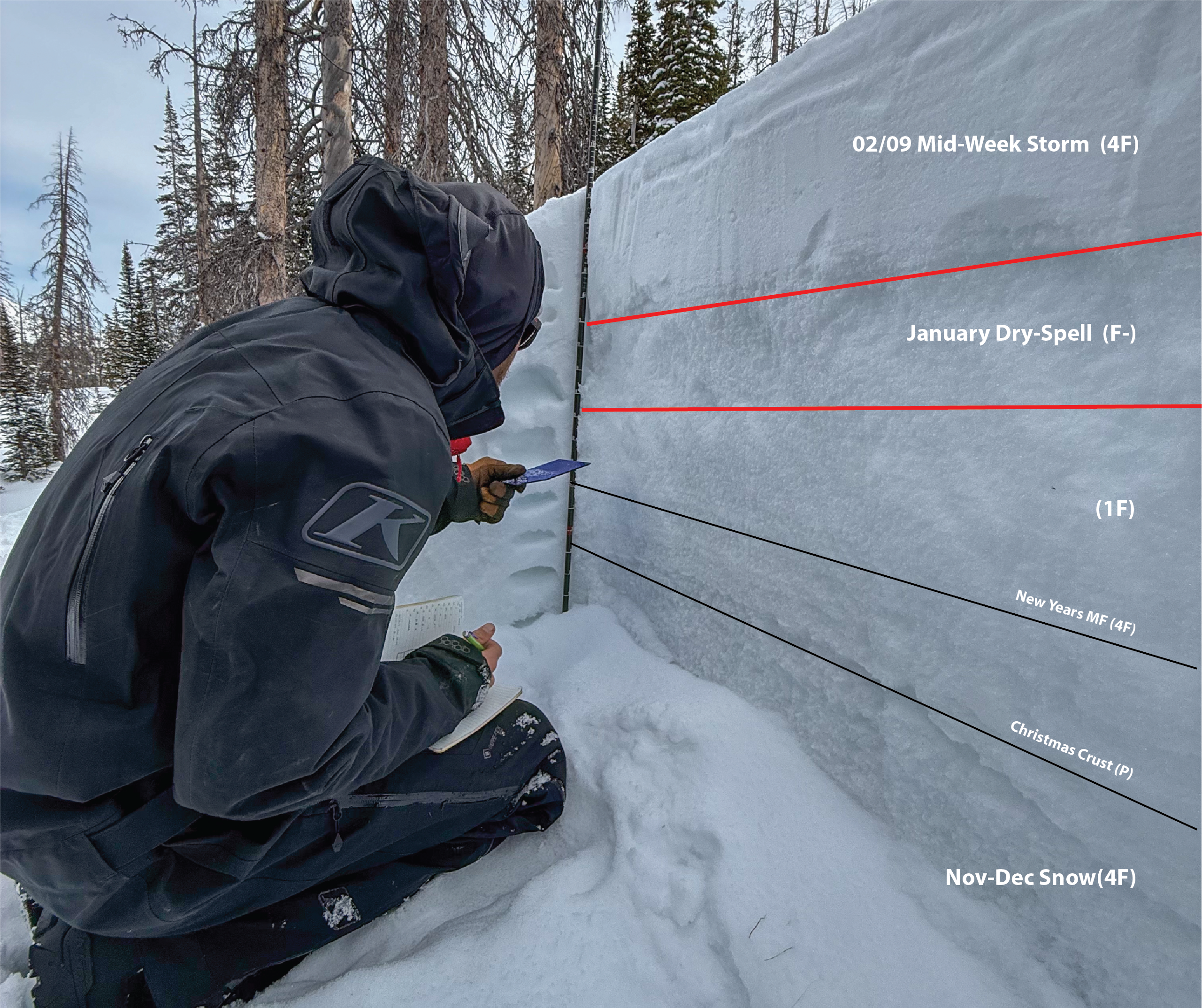
A simplified look at the current structure, and how last weeks storm has protected and preserved the near surface facets from the January dry-spell (via K. Cheston).


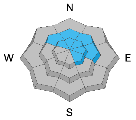
A persistent weak layer of near surface facets that formed over the long stretch of dry, January weather is now protected and preserved beneath our most recent storms. On mid and upper elevation polar slopes, this weak layer is buried nearly 2' beneath the snow surface, is reactive to our additional weight, and can be triggered remotely or from a distance.

Avoiding steep, wind-drifted slopes is the ticket today. Bullseye terrain includes thin, rocky areas that are trigger points, where the snowpack is more susceptible to our additional weight.

In addition, we've been noticing lots of red flags, like cracking and collapsing sounds, which are huge red flags and obvious clues to unstable snow. Don't forget, there's no shortage of weak snow buried and protected beneath the surface, and now there's a strong, dense slab resting on top... it's game on!

Don't forget, we can always avoid this avalanche dragon altogether by riding slopes less than 30° with no overhead hazard, simply meaning... no steep terrain above or adjacent to us.

Yesterday, Michael H was in the Washington Lake area at upper elevations and had a fantastic observation and Extended Column Test (ECTP6) highlighting the January Dry-Spell facets, how sensitive they are, and the house of cards that we are about to stack some serious snow on top of (via M. Holbrook).

Additional Information

Join the UAC for the first "Stay and Play Avalanche Course" at Bear River Lodge in the Uintas, March 19th-22nd. This course is designed for snowmobilers by snowmobilers, where you will learn avalanche rescue, riding skills, and how to survive in the backcountry. Come enjoy all the luxury offerings at Bear River Lodge and improve your skills along the way.

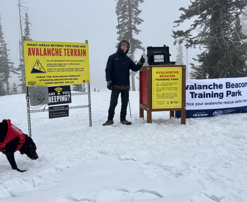
Our Avalanche Rescue Training Park is set-up and located at the top of Wolf Creek Pass, SR-35, and is waiting for you to come take it for a spin! Open up the control unit, flip a few switches, and dial in your avalanche rescue skills with this roadside attraction!

General Announcements

We have some upcoming classes and events that we'd be stoked to see you at -- Please reach out with any questions and check out below for more details!

We are always looking for snow and avalanche observations or just general riding conditions. Reach out to us with questions, concerns, or if you see anything in your travels! Contact us directly through the info below:

This forecast is from the U.S.D.A. Forest Service, which is solely responsible for its content. This forecast describes general avalanche conditions, and local variations always occur. This forecast was issued on Tuesday, February 17th at 0400 and expires 24 hours after it was issued. We'll update this information by 07:00 AM tomorrow